This is a list of the extreme points of Ireland – the points that are farthest north, south, east or west in Ireland. It includes the Republic of Ireland and Northern Ireland.

North Antrim is a parliamentary constituency in the United Kingdom House of Commons. Its current member is Ian Paisley Jr.
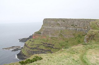
Benbane Head, or Benbane, is the northernmost point of mainland Northern Ireland. It is in County Antrim, near the Giant's Causeway, which lies between Causeway Head and Benbane Head. The nearest settlements are Bushmills and Portballintrae.

Ballintoy is a small village, townland and civil parish in County Antrim, Northern Ireland. It is alongside the B15 coast road, 28 km (17 mi) north-east of Coleraine, 8 km (5.0 mi) west of Ballycastle and between it and Bushmills. It is in the historic barony of Cary. The village lies about one kilometre from Ballintoy Harbour, a small fishing harbour at the end of a very small, narrow, steep road down Knocksaughey hill which passes by the entrance to Larrybane and Carrick-a-Rede Rope Bridge. The harbour is host to a dawn service on Easter Sunday each year.

Stranocum is a small village and townland in County Antrim, Northern Ireland. The villages of Dervock and Armoy are nearby and the town of Ballymoney is about 5 miles (8.0 km) away. It had a population of 297 people in the 2011 Census.

The Glens of Antrim, known locally as simply The Glens, is a region of County Antrim, Northern Ireland. It comprises nine glens (valleys), that radiate from the Antrim Plateau to the coast. The Glens are an area of outstanding natural beauty and are a major tourist attraction in north Antrim.

North Antrim was a constituency of the Northern Ireland House of Commons.
Barmeen is a townland in County Antrim, Northern Ireland. It is located at the foot of Glendun, one of the nine Glens of Antrim, west of Cushendun and north of Knocknacarry. It is situated in the historic barony of Cary and the civil parish of Culfeightrin and covers 59 acres.
Knocknacarry is a hamlet and townland about 1 kilometre west of Cushendun in County Antrim, Northern Ireland. It is situated in the historic barony of Glenarm Lower and the civil parish of Layd. In the 2001 Census it had a population of 138 people. It is within the Moyle District Council area.
Ballyvoy is a small village and townland in County Antrim, Northern Ireland. It is on the main A2 coast road 5 km east of Ballycastle and 17 km north west of Cushendall. In the 2001 Census it had a population of 72 people. It lies within the Antrim Coast and Glens Area of Outstanding Natural Beauty and is part of Causeway Coast and Glens District Council.
Moss-side or Mosside is a small village and townland in County Antrim, Northern Ireland. In the 2001 Census it had a population of 270 people.

Glendun translates into English as glen of the brown river and is one of the nine Glens of Antrim in County Antrim in Northern Ireland.

Tievebulliagh is a 554-metre-high (1,818 ft) mountain in the Glens of Antrim, Northern Ireland. It forms part of the watershed between Glenaan to the north and Glenballyemon to the south. It is situated about 4.4 km from Cushendall.
Events from the year 1565 in Ireland.

The River Bush is a river in County Antrim, Northern Ireland. The River Bush is 33.5 miles (53.9 km) long. The river's source is in the Antrim Hills at 480m. From there the river flows northwest, with a bend at the town of Armoy. It then flows west, passing through Stranocum, and then bends north, passing through Bushmills before reaching the sea at Portballintrae on the North Antrim coast. It flows through a fertile valley devoted to grassland-based agriculture with limited arable cropping. The underlying geology is basalt and the water is slightly alkaline with magnesium making an unusually large contribution to total hardness. The river supports indigenous stocks of Atlantic salmon and brown trout. Saint Columb's Rill, which is a tributary of the river, is the source of water used for distilling Bushmills whiskey.

The River Dun, also known as the Glendun River is a river in County Antrim, Northern Ireland. It runs through Glendun, one of the nine Glens of Antrim. The river is named after its brown colour, which comes from the peat bogs at its source on the slopes of Slievenanee on the Antrim Plateau. The source of the river is a few hundred metres from that of the River Bush, which flows north-east to meet the sea at Bushmills. Cushendun is a small coastal resort town lying at the mouth of the River Dun and Glendun.

Glenshesk is one of the nine Glens of Antrim in County Antrim, Northern Ireland. It was shaped during the Ice Age by glaciers. The glen lies on the eastern side of Knocklayde mountain and flows out to the sea at Ballycastle.

Cary is a historic barony in County Antrim, Northern Ireland. To its north is the north-Antrim coast, and it is bordered by three other baronies: Dunluce Lower to the west; Dunluce Upper to the south; and Glenarm Lower to the south-east. The world-famous Giant's Causeway is situated on the north coast of Cary. Dunineny Castle lies in the civil parish of Ramoan within this barony.
James Black is an Irish sportsperson. He plays hurling with his local club Glenshesk, having previously played for Glenshesk and has been a member of the Antrim senior inter-county hurling team since 2011. He was deputy Head boy at his school of Cross and Passion College where he won two All Ireland O'Keefe Cup medals and captained the side in their 2011 Magean Cup Campaign. An avid farmer he runs farms in both Carey and Scotland and holds a degree from University of Ulster in Sports Science. Known for his skill both on and off the pitch he is a keen pintman during the off season.


