Gmina Bałtów

Last updated
Gmina Bałtów
Bałtów Commune
Gmina
POL gmina Baltow flag.svg
Flag
POL gmina Baltow COA.svg
Coat of arms
Coordinates(Bałtów): 51°1′N21°33′E / 51.017°N 21.550°E / 51.017; 21.550 Coordinates: 51°1′N21°33′E / 51.017°N 21.550°E / 51.017; 21.550
CountryFlag of Poland.svg  Poland
Voivodeship Świętokrzyskie
County Ostrowiec
Seat Bałtów
Area
  Total 104.92 km2 (40.51 sq mi)
Population (2006)
  Total 3,999
  Density 38/km2 (99/sq mi)
Website http://www.gminabaltow.pl/ [1]

Gmina Bałtów is a rural gmina (administrative district) in Ostrowiec County, Świętokrzyskie Voivodeship, in south-central Poland. Its seat is the village of Bałtów, which lies approximately 15 kilometres (9 mi) north-east of Ostrowiec Świętokrzyski and 68 km (42 mi) east of the regional capital Kielce.

Gmina administrative division of Poland

The gmina is the principal unit of the administrative division of Poland, similar to a municipality. As of 2010 there were 2,478 gminy throughout the country. The word gmina derives from the German word Gemeinde, meaning "community".

Ostrowiec County County in Świętokrzyskie, Poland

Ostrowiec County is a unit of territorial administration and local government (powiat) in Świętokrzyskie Voivodeship, south-central Poland. It came into being on January 1, 1999, as a result of the Polish local government reforms passed in 1998. Its administrative seat and largest town is Ostrowiec Świętokrzyski, which lies 56 kilometres (35 mi) east of the regional capital Kielce. The county also contains the towns of Ćmielów, lying 10 km (6 mi) south-east of Ostrowiec Świętokrzyski, and Kunów, 9 km (6 mi) west of Ostrowiec Świętokrzyski.

Świętokrzyskie Voivodeship Voivodeship in Poland

Świętokrzyskie Voivodeship, Świętokrzyskie Province, or Holy Cross Province is one of the 16 voivodeships (provinces) into which Poland is divided. It is situated in southeastern Poland, in the historical province of Lesser Poland, and takes its name from the Świętokrzyskie mountain range. Its capital and largest city is Kielce.

Contents

The gmina covers an area of 104.92 square kilometres (40.5 sq mi), and as of 2006 its total population is 3,999.

Villages

Gmina Bałtów contains the villages and settlements of Antoniów, Bałtów, Bidzińszczyzna, Borcuchy, Lemierze, Maksymilianów, Michałów, Okół, Pętkowice, Rudka Bałtowska, Skarbka, Ulów, Wólka Bałtowska, Wólka Pętkowska, Wólka Trzemecka and Wycinka.

Antoniów, Świętokrzyskie Voivodeship Village in Świętokrzyskie, Poland

Antoniów is a village in the administrative district of Gmina Bałtów, within Ostrowiec County, Świętokrzyskie Voivodeship, in south-central Poland. It lies approximately 5 kilometres (3 mi) north of Bałtów, 17 km (11 mi) north-east of Ostrowiec Świętokrzyski, and 67 km (42 mi) east of the regional capital Kielce.

Bałtów, Świętokrzyskie Voivodeship Village in Świętokrzyskie, Poland

Bałtów is a village in Ostrowiec County, Świętokrzyskie Voivodeship, in south-central Poland. It is the seat of the gmina called Gmina Bałtów. It lies approximately 15 kilometres (9 mi) north-east of Ostrowiec Świętokrzyski and 68 km (42 mi) east of the regional capital Kielce.

Borcuchy Village in Świętokrzyskie, Poland

Borcuchy is a village in the administrative district of Gmina Bałtów, within Ostrowiec County, Świętokrzyskie Voivodeship, in south-central Poland. It lies approximately 4 kilometres (2 mi) north-west of Bałtów, 14 km (9 mi) north-east of Ostrowiec Świętokrzyski, and 65 km (40 mi) east of the regional capital Kielce.

Neighbouring gminas

Gmina Bałtów is bordered by the gminas of Bodzechów, Ćmielów, Sienno and Tarłów.

Gmina Bodzechów is a rural gmina in Ostrowiec County, Świętokrzyskie Voivodeship, in south-central Poland. The district takes its name from the village of Bodzechów, but its administrative offices are in the town of Ostrowiec Świętokrzyski, which is not part of the territory of the gmina.

Gmina Ćmielów is an urban-rural gmina in Ostrowiec County, Świętokrzyskie Voivodeship, in south-central Poland. Its seat is the town of Ćmielów, which lies approximately 10 kilometres (6 mi) south-east of Ostrowiec Świętokrzyski and 64 km (40 mi) east of the regional capital Kielce.

Gmina Sienno is a rural gmina in Lipsko County, Masovian Voivodeship, in east-central Poland. Its seat is the village of Sienno, which lies approximately 15 kilometres (9 mi) south-west of Lipsko and 130 km (81 mi) south of Warsaw.

Related Research Articles

Gmina Andrespol is a rural gmina in Łódź East County, Łódź Voivodeship, in central Poland. Its seat is the village of Andrespol, which lies approximately 14 kilometres (9 mi) south-east of the regional capital Łódź.

Gmina Bejsce is a rural gmina in Kazimierza County, Świętokrzyskie Voivodeship, in south-central Poland. Its seat is the village of Bejsce, which lies approximately 10 kilometres (6 mi) east of Kazimierza Wielka and 71 km (44 mi) south of the regional capital Kielce.

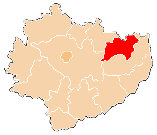
Gmina Tarłów is a rural gmina in Opatów County, Świętokrzyskie Voivodeship, in south-central Poland. Its seat is the village of Tarłów, which lies approximately 30 kilometres (19 mi) north-east of Opatów and 79 km (49 mi) east of the regional capital Kielce.

Lemierze Village in Świętokrzyskie, Poland

Lemierze is a village in the administrative district of Gmina Bałtów, within Ostrowiec County, Świętokrzyskie Voivodeship, in south-central Poland. It lies approximately 4 kilometres (2 mi) south of Bałtów, 13 km (8 mi) north-east of Ostrowiec Świętokrzyski, and 68 km (42 mi) east of the regional capital Kielce.

Maksymilianów, Świętokrzyskie Voivodeship Village in Świętokrzyskie, Poland

Maksymilianów is a village in the administrative district of Gmina Bałtów, within Ostrowiec County, Świętokrzyskie Voivodeship, in south-central Poland. It lies approximately 5 kilometres (3 mi) south-west of Bałtów, 10 km (6 mi) north-east of Ostrowiec Świętokrzyski, and 64 km (40 mi) east of the regional capital Kielce.

Michałów, Ostrowiec County Village in Świętokrzyskie, Poland

Michałów is a village in the administrative district of Gmina Bałtów, within Ostrowiec County, Świętokrzyskie Voivodeship, in south-central Poland. It lies approximately 5 kilometres (3 mi) north-east of Bałtów, 19 km (12 mi) north-east of Ostrowiec Świętokrzyski, and 71 km (44 mi) east of the regional capital Kielce.

Okół, Świętokrzyskie Voivodeship Village in Świętokrzyskie, Poland

Okół is a village in the administrative district of Gmina Bałtów, within Ostrowiec County, Świętokrzyskie Voivodeship, in south-central Poland. It lies approximately 6 kilometres (4 mi) east of Bałtów, 20 km (12 mi) north-east of Ostrowiec Świętokrzyski, and 73 km (45 mi) east of the regional capital Kielce.

Pętkowice, Świętokrzyskie Voivodeship Village in Świętokrzyskie, Poland

Pętkowice is a village in the administrative district of Gmina Bałtów, within Ostrowiec County, Świętokrzyskie Voivodeship, in south-central Poland. It lies approximately 4 kilometres (2 mi) east of Bałtów, 17 km (11 mi) north-east of Ostrowiec Świętokrzyski, and 71 km (44 mi) east of the regional capital Kielce.

Rudka Bałtowska Village in Świętokrzyskie, Poland

Rudka Bałtowska is a village in the administrative district of Gmina Bałtów, within Ostrowiec County, Świętokrzyskie Voivodeship, in south-central Poland. It lies approximately 3 kilometres (2 mi) south-west of Bałtów, 12 km (7 mi) north-east of Ostrowiec Świętokrzyski, and 65 km (40 mi) east of the regional capital Kielce.

Skarbka Village in Świętokrzyskie, Poland

Skarbka is a village in the administrative district of Gmina Bałtów, within Ostrowiec County, Świętokrzyskie Voivodeship, in south-central Poland. It lies approximately 3 kilometres (2 mi) east of Bałtów, 16 km (10 mi) north-east of Ostrowiec Świętokrzyski, and 69 km (43 mi) east of the regional capital Kielce.

Ulów, Świętokrzyskie Voivodeship Village in Świętokrzyskie, Poland

Ulów is a village in the administrative district of Gmina Bałtów, within Ostrowiec County, Świętokrzyskie Voivodeship, in south-central Poland. It lies approximately 4 kilometres (2 mi) south-east of Bałtów, 14 km (9 mi) north-east of Ostrowiec Świętokrzyski, and 69 km (43 mi) east of the regional capital Kielce.

Wólka Bałtowska Village in Świętokrzyskie, Poland

Wólka Bałtowska is a village in the administrative district of Gmina Bałtów, within Ostrowiec County, Świętokrzyskie Voivodeship, in south-central Poland. It lies approximately 3 kilometres (2 mi) north-west of Bałtów, 15 km (9 mi) north-east of Ostrowiec Świętokrzyski, and 67 km (42 mi) east of the regional capital Kielce.

Wólka Pętkowska Village in Świętokrzyskie, Poland

Wólka Pętkowska is a village in the administrative district of Gmina Bałtów, within Ostrowiec County, Świętokrzyskie Voivodeship, in south-central Poland. It lies approximately 5 kilometres (3 mi) east of Bałtów, 17 km (11 mi) north-east of Ostrowiec Świętokrzyski, and 72 km (45 mi) east of the regional capital Kielce.

Wólka Trzemecka Village in Świętokrzyskie, Poland

Wólka Trzemecka is a village in the administrative district of Gmina Bałtów, within Ostrowiec County, Świętokrzyskie Voivodeship, in south-central Poland. It lies approximately 4 kilometres (2 mi) north-west of Bałtów, 15 km (9 mi) north-east of Ostrowiec Świętokrzyski, and 66 km (41 mi) east of the regional capital Kielce.

Wycinka Village in Świętokrzyskie, Poland

Wycinka is a village in the administrative district of Gmina Bałtów, within Ostrowiec County, Świętokrzyskie Voivodeship, in south-central Poland. It lies approximately 4 kilometres (2 mi) south-east of Bałtów, 14 km (9 mi) north-east of Ostrowiec Świętokrzyski, and 69 km (43 mi) east of the regional capital Kielce.

References

  1. "BIP: www.bip.gminabaltow.pl". www.bip.gov.pl (in Polish). Archived from the original on 6 December 2010. Retrieved 23 June 2016.