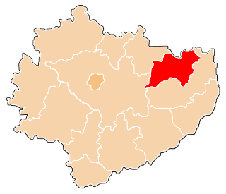
Ostrowiec County is a unit of territorial administration and local government (powiat) in Świętokrzyskie Voivodeship, south-central Poland. It came into being on January 1, 1999, as a result of the Polish local government reforms passed in 1998. Its administrative seat and largest town is Ostrowiec Świętokrzyski, which lies 56 kilometres (35 mi) east of the regional capital Kielce. The county also contains the towns of Ćmielów, lying 10 km (6 mi) south-east of Ostrowiec Świętokrzyski, and Kunów, 9 km (6 mi) west of Ostrowiec Świętokrzyski.
Gmina Bałtów is a rural gmina in Ostrowiec County, Świętokrzyskie Voivodeship, in south-central Poland. Its seat is the village of Bałtów, which lies approximately 15 kilometres (9 mi) north-east of Ostrowiec Świętokrzyski and 68 km (42 mi) east of the regional capital Kielce.
Gmina Bodzechów is a rural gmina in Ostrowiec County, Świętokrzyskie Voivodeship, in south-central Poland. The district takes its name from the village of Bodzechów, but its administrative offices are in the town of Ostrowiec Świętokrzyski, which is not part of the territory of the gmina.
Gmina Ćmielów is an urban-rural gmina in Ostrowiec County, Świętokrzyskie Voivodeship, in south-central Poland. Its seat is the town of Ćmielów, which lies approximately 10 kilometres (6 mi) south-east of Ostrowiec Świętokrzyski and 64 km (40 mi) east of the regional capital Kielce.

Bałtów is a village in Ostrowiec County, Świętokrzyskie Voivodeship, in southeastern Poland. It is the seat of the gmina called Gmina Bałtów. It lies approximately 15 kilometres (9 mi) northeast of Ostrowiec Świętokrzyski and 68 km (42 mi) east of the regional capital Kielce.
Bidzińszczyzna is a village in the administrative district of Gmina Bałtów, within Ostrowiec County, Świętokrzyskie Voivodeship, in south-central Poland. It lies approximately 3 kilometres (2 mi) east of Bałtów, 16 km (10 mi) north-east of Ostrowiec Świętokrzyski, and 70 km (43 mi) east of the regional capital Kielce.
Borcuchy is a village in the administrative district of Gmina Bałtów, within Ostrowiec County, Świętokrzyskie Voivodeship, in south-central Poland. It lies approximately 4 kilometres (2 mi) north-west of Bałtów, 14 km (9 mi) north-east of Ostrowiec Świętokrzyski, and 65 km (40 mi) east of the regional capital Kielce.
Lemierze is a village in the administrative district of Gmina Bałtów, within Ostrowiec County, Świętokrzyskie Voivodeship, in south-central Poland. It lies approximately 4 kilometres (2 mi) south of Bałtów, 13 km (8 mi) north-east of Ostrowiec Świętokrzyski, and 68 km (42 mi) east of the regional capital Kielce.
Maksymilianów is a village in the administrative district of Gmina Bałtów, within Ostrowiec County, Świętokrzyskie Voivodeship, in south-central Poland. It lies approximately 5 kilometres (3 mi) south-west of Bałtów, 10 km (6 mi) north-east of Ostrowiec Świętokrzyski, and 64 km (40 mi) east of the regional capital Kielce.
Okół is a village in the administrative district of Gmina Bałtów, within Ostrowiec County, Świętokrzyskie Voivodeship, in south-central Poland. It lies approximately 6 kilometres (4 mi) east of Bałtów, 20 km (12 mi) north-east of Ostrowiec Świętokrzyski, and 73 km (45 mi) east of the regional capital Kielce.
Pętkowice is a village in the administrative district of Gmina Bałtów, within Ostrowiec County, Świętokrzyskie Voivodeship, in south-central Poland. It lies approximately 4 kilometres (2 mi) east of Bałtów, 17 km (11 mi) north-east of Ostrowiec Świętokrzyski, and 71 km (44 mi) east of the regional capital Kielce.
Rudka Bałtowska is a village in the administrative district of Gmina Bałtów, within Ostrowiec County, Świętokrzyskie Voivodeship, in south-central Poland. It lies approximately 3 kilometres (2 mi) south-west of Bałtów, 12 km (7 mi) north-east of Ostrowiec Świętokrzyski, and 65 km (40 mi) east of the regional capital Kielce.
Ulów is a village in the administrative district of Gmina Bałtów, within Ostrowiec County, Świętokrzyskie Voivodeship, in south-central Poland. It lies approximately 4 kilometres (2 mi) south-east of Bałtów, 14 km (9 mi) north-east of Ostrowiec Świętokrzyski, and 69 km (43 mi) east of the regional capital Kielce.
Wólka Bałtowska is a village in the administrative district of Gmina Bałtów, within Ostrowiec County, Świętokrzyskie Voivodeship, in south-central Poland. It lies approximately 3 kilometres (2 mi) north-west of Bałtów, 15 km (9 mi) north-east of Ostrowiec Świętokrzyski, and 67 km (42 mi) east of the regional capital Kielce.
Wólka Pętkowska is a village in the administrative district of Gmina Bałtów, within Ostrowiec County, Świętokrzyskie Voivodeship, in south-central Poland. It lies approximately 5 kilometres (3 mi) east of Bałtów, 17 km (11 mi) north-east of Ostrowiec Świętokrzyski, and 72 km (45 mi) east of the regional capital Kielce.
Wólka Trzemecka is a village in the administrative district of Gmina Bałtów, within Ostrowiec County, Świętokrzyskie Voivodeship, in south-central Poland. It lies approximately 4 kilometres (2 mi) north-west of Bałtów, 15 km (9 mi) north-east of Ostrowiec Świętokrzyski, and 66 km (41 mi) east of the regional capital Kielce.
Wycinka is a village in the administrative district of Gmina Bałtów, within Ostrowiec County, Świętokrzyskie Voivodeship, in south-central Poland. It lies approximately 4 kilometres (2 mi) south-east of Bałtów, 14 km (9 mi) north-east of Ostrowiec Świętokrzyski, and 69 km (43 mi) east of the regional capital Kielce.
Jastków is a village in the administrative district of Gmina Ćmielów, within Ostrowiec County, Świętokrzyskie Voivodeship, in south-central Poland. It lies approximately 3 kilometres (2 mi) south-east of Ćmielów, 12 km (7 mi) south-east of Ostrowiec Świętokrzyski, and 65 km (40 mi) east of the regional capital Kielce.
Podgrodzie is a village in the administrative district of Gmina Ćmielów, within Ostrowiec County, Świętokrzyskie Voivodeship, in south-central Poland. It lies approximately 3 kilometres (2 mi) north-east of Ćmielów, 11 km (7 mi) east of Ostrowiec Świętokrzyski, and 66 km (41 mi) east of the regional capital Kielce.
Trębanów is a village in the administrative district of Gmina Ćmielów, within Ostrowiec County, Świętokrzyskie Voivodeship, in south-central Poland. It lies approximately 5 kilometres (3 mi) south-west of Ćmielów, 11 km (7 mi) south-east of Ostrowiec Świętokrzyski, and 62 km (39 mi) east of the regional capital Kielce.


