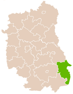
Gmina Horodło is a rural gmina in Hrubieszów County, Lublin Voivodeship, in eastern Poland, on the border with Ukraine. Its seat is the village of Horodło, which lies approximately 13 kilometres (8 mi) north-east of Hrubieszów and 111 km (69 mi) east of the regional capital Lublin.

Dołhobyczów is a village in Hrubieszów County, Lublin Voivodeship, in eastern Poland, close to the border with Ukraine. It is the seat of the gmina called Gmina Dołhobyczów. It lies approximately 28 kilometres (17 mi) south-east of Hrubieszów and 127 km (79 mi) south-east of the regional capital Lublin.

Dołhobyczów-Kolonia is a village in the administrative district of Gmina Dołhobyczów, within Hrubieszów County, Lublin Voivodeship, in eastern Poland, close to the border with Ukraine. It lies approximately 3 kilometres (2 mi) east of Dołhobyczów, 30 km (19 mi) south-east of Hrubieszów, and 129 km (80 mi) south-east of the regional capital Lublin.

Gołębie is a village in the administrative district of Gmina Dołhobyczów, within Hrubieszów County, Lublin Voivodeship, in eastern Poland, close to the border with Ukraine. It lies approximately 7 kilometres (4 mi) north-east of Dołhobyczów, 24 km (15 mi) south-east of Hrubieszów, and 126 km (78 mi) south-east of the regional capital Lublin.

Honiatyn is a village in the administrative district of Gmina Dołhobyczów, within Hrubieszów County, Lublin Voivodeship, in eastern Poland, close to the border with Ukraine. It lies approximately 4 kilometres (2 mi) south-east of Dołhobyczów, 32 km (20 mi) south-east of Hrubieszów, and 131 km (81 mi) south-east of the regional capital Lublin.

Hulcze is a village in the administrative district of Gmina Dołhobyczów, within Hrubieszów County, Lublin Voivodeship, in eastern Poland, close to the border with Ukraine. It lies approximately 10 kilometres (6 mi) south of Dołhobyczów, 37 km (23 mi) south of Hrubieszów, and 132 km (82 mi) south-east of the regional capital Lublin.

Kadłubiska is a village in the administrative district of Gmina Dołhobyczów, within Hrubieszów County, Lublin Voivodeship, in eastern Poland, close to the border with Ukraine. It lies approximately 2 kilometres (1 mi) west of Dołhobyczów, 28 km (17 mi) south of Hrubieszów, and 126 km (78 mi) south-east of the regional capital Lublin.

Lipina is a village in the administrative district of Gmina Dołhobyczów, within Hrubieszów County, Lublin Voivodeship, in eastern Poland, close to the border with Ukraine. It lies approximately 16 kilometres (10 mi) south-west of Dołhobyczów, 39 km (24 mi) south of Hrubieszów, and 128 km (80 mi) south-east of the regional capital Lublin.

Liwcze is a village in the administrative district of Gmina Dołhobyczów, within Hrubieszów County, Lublin Voivodeship, in eastern Poland, close to the border with Ukraine. It lies approximately 10 kilometres (6 mi) south of Dołhobyczów, 37 km (23 mi) south of Hrubieszów, and 133 km (83 mi) south-east of the regional capital Lublin.

Mołczany is a village in the administrative district of Gmina Dołhobyczów, within Hrubieszów County, Lublin Voivodeship, in eastern Poland, close to the border with Ukraine. It lies approximately 2 kilometres (1 mi) north of Dołhobyczów, 26 km (16 mi) south-east of Hrubieszów, and 125 km (78 mi) south-east of the regional capital Lublin.

Myców is a village in the administrative district of Gmina Dołhobyczów, within Hrubieszów County, Lublin Voivodeship, in eastern Poland, close to the border with Ukraine. It lies approximately 18 kilometres (11 mi) south of Dołhobyczów, 44 km (27 mi) south of Hrubieszów, and 135 km (84 mi) south-east of the regional capital Lublin.

Oszczów-Kolonia is a village in the administrative district of Gmina Dołhobyczów, within Hrubieszów County, Lublin Voivodeship, in eastern Poland, close to the border with Ukraine. It lies approximately 6 kilometres (4 mi) south of Dołhobyczów, 33 km (21 mi) south of Hrubieszów, and 130 km (81 mi) south-east of the regional capital Lublin.

Podhajczyki is a village in the administrative district of Gmina Dołhobyczów, within Hrubieszów County, Lublin Voivodeship, in eastern Poland, close to the border with Ukraine. It lies approximately 4 kilometres (2 mi) north-west of Dołhobyczów, 26 km (16 mi) south of Hrubieszów, and 123 km (76 mi) south-east of the regional capital Lublin.

Sulimów-Kolonia is a village in the administrative district of Gmina Dołhobyczów, within Hrubieszów County, Lublin Voivodeship, in eastern Poland, close to the border with Ukraine. It lies approximately 8 kilometres (5 mi) south of Dołhobyczów, 36 km (22 mi) south of Hrubieszów, and 132 km (82 mi) south-east of the regional capital Lublin.

Uśmierz is a village in the administrative district of Gmina Dołhobyczów, within Hrubieszów County, Lublin Voivodeship, in eastern Poland, close to the border with Ukraine. It lies approximately 6 kilometres (4 mi) south of Dołhobyczów, 34 km (21 mi) south-east of Hrubieszów, and 132 km (82 mi) south-east of the regional capital Lublin.

Zaręka is a village in the administrative district of Gmina Dołhobyczów, within Hrubieszów County, Lublin Voivodeship, in eastern Poland, close to the border with Ukraine. It lies approximately 5 kilometres (3 mi) north-east of Dołhobyczów, 26 km (16 mi) south-east of Hrubieszów, and 127 km (79 mi) south-east of the regional capital Lublin.

Żniatyn is a village in the administrative district of Gmina Dołhobyczów, within Hrubieszów County, Lublin Voivodeship, in eastern Poland, close to the border with Ukraine. It lies approximately 13 kilometres (8 mi) south of Dołhobyczów, 39 km (24 mi) south of Hrubieszów, and 131 km (81 mi) south-east of the regional capital Lublin.
A new border crossing has recently opened providing direct access to Ukraine, you can see the building on Google Earth.


