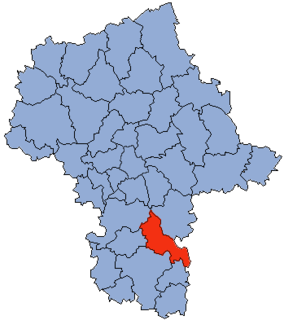
Gmina Głowaczów Głowaczów Commune | |||
---|---|---|---|
Gmina | |||
| |||
Coordinates(Głowaczów): 51°37′16″N21°19′8″E / 51.62111°N 21.31889°E Coordinates: 51°37′16″N21°19′8″E / 51.62111°N 21.31889°E | |||
Country | |||
Voivodeship | Masovian | ||
County | Kozienice | ||
Seat | Głowaczów | ||
Area | |||
• Total | 186.26 km2 (71.92 sq mi) | ||
Population (2006) | |||
• Total | 7,292 | ||
• Density | 39/km2 (100/sq mi) | ||
Website | http://www.glowaczow.pl/ |
Gmina Głowaczów is a rural gmina (administrative district) in Kozienice County, Masovian Voivodeship, in east-central Poland. Its seat is the village of Głowaczów, which lies approximately 18 kilometres (11 mi) west of Kozienice and 70 km (43 mi) south of Warsaw.
The gmina is the principal unit of the administrative division of Poland, similar to a municipality. As of 2010 there were 2,478 gminy throughout the country. The word gmina derives from the German word Gemeinde, meaning "community".
Kozienice County is a unit of territorial administration and local government (powiat) in Masovian Voivodeship, east-central Poland. It came into being on January 1, 1999, as a result of the Polish local government reforms passed in 1998. Its administrative seat and only town is Kozienice, which lies 81 kilometres (50 mi) south-east of Warsaw.
Mazovian Voivodeship or Mazovia Province is the largest and most populous of the 16 Polish provinces, or voivodeships, created in 1999. It occupies 35,579 square kilometres (13,737 sq mi) of east-central Poland, and has 5,324,500 inhabitants. Its principal cities are Warsaw in the centre of the Warsaw metropolitan area, Radom (226,000) in the south, Płock (127,000) in the west, Siedlce (77,000) in the east, and Ostrołęka (55,000) in the north. The capital of the voivodeship is the national capital, Warsaw.
The gmina covers an area of 186.26 square kilometres (71.9 sq mi), and as of 2006 its total population is 7,292.
Gmina Głowaczów contains the villages and settlements of Adamów, Bobrowniki, Brzóza, Cecylówka, Cecylówka-Brzózka, Chodków, Dąbrówki, Emilów, Głowaczów, Grabnowola, Helenów, Henryków, Ignacówka, Ignacówka Bobrowska, Jasieniec, Klementynów, Kosny, Leżenice, Lipa, Lipska Wola, Łukawa, Łukawska Wola, Maciejowice, Mariampol, Marianów, Michałów, Miejska Dąbrowa, Moniochy, Podmieście, Przejazd, Rogożek, Sewerynów, Stanisławów, Stawki, Studnie, Studzianki Pancerne, Ursynów, Wólka Brzózka and Zieleniec.
Adamów is a village in the administrative district of Gmina Głowaczów, within Kozienice County, Masovian Voivodeship, in east-central Poland. It lies approximately 5 kilometres (3 mi) east of Głowaczów, 14 km (9 mi) north-west of Kozienice, and 70 km (43 mi) south of Warsaw.
Bobrowniki is a village in the administrative district of Gmina Głowaczów, within Kozienice County, Masovian Voivodeship, in east-central Poland. It lies approximately 4 kilometres (2 mi) south-west of Głowaczów, 20 km (12 mi) west of Kozienice, and 72 km (45 mi) south of Warsaw.
Brzóza is a village in the administrative district of Gmina Głowaczów, within Kozienice County, Masovian Voivodeship, in east-central Poland. It lies approximately 4 kilometres (2 mi) south-east of Głowaczów, 16 km (10 mi) west of Kozienice, and 73 km (45 mi) south of Warsaw.
Gmina Głowaczów is bordered by the gminas of Grabów nad Pilicą, Jastrzębia, Jedlińsk, Kozienice, Magnuszew, Pionki and Stromiec.
Gmina Grabów nad Pilicą is a rural gmina in Kozienice County, Masovian Voivodeship, in east-central Poland. Its seat is the village of Grabów nad Pilicą, which lies approximately 29 kilometres (18 mi) north-west of Kozienice and 57 km (35 mi) south of Warsaw.
Gmina Jastrzębia is a rural gmina in Radom County, Masovian Voivodeship, in east-central Poland. Its seat is the village of Jastrzębia, which lies approximately 12 kilometres (7 mi) north-east of Radom and 83 km (51 mi) south of Warsaw.
Gmina Jedlińsk is a rural gmina in Radom County, Masovian Voivodeship, in east-central Poland. Its seat is the village of Jedlińsk, which lies approximately 14 kilometres (9 mi) north of Radom and 79 km (49 mi) south of Warsaw.
Gmina Stromiec is a rural gmina in Białobrzegi County, Masovian Voivodeship, in east-central Poland. Its seat is the village of Stromiec, which lies approximately 10 kilometres (6 mi) east of Białobrzegi and 65 km (40 mi) south of Warsaw.
Gmina Kozienice is an urban-rural gmina in Kozienice County, Masovian Voivodeship, in east-central Poland. Its seat is the town of Kozienice, which lies approximately 81 kilometres (50 mi) south-east of Warsaw.
Gmina Magnuszew is a rural gmina in Kozienice County, Masovian Voivodeship, in east-central Poland. Its seat is the village of Magnuszew, which lies approximately 24 kilometres (15 mi) north-west of Kozienice and 57 km (35 mi) south-east of Warsaw.
Gmina Sieciechów is a rural gmina in Kozienice County, Masovian Voivodeship, in east-central Poland. Its seat is the village of Sieciechów, which lies approximately 14 kilometres (9 mi) east of Kozienice and 91 km (57 mi) south-east of Warsaw.
Gmina Sochaczew is a rural gmina in Sochaczew County, Masovian Voivodeship, in east-central Poland. Its seat is the town of Sochaczew, although the town is not part of the territory of the gmina.
Chodków is a village in the administrative district of Gmina Głowaczów, within Kozienice County, Masovian Voivodeship, in east-central Poland. It lies approximately 7 kilometres (4 mi) north-east of Głowaczów, 16 km (10 mi) north-west of Kozienice, and 67 km (42 mi) south-east of Warsaw.
Dąbrówki is a village in the administrative district of Gmina Głowaczów, within Kozienice County, Masovian Voivodeship, in east-central Poland. It lies approximately 6 kilometres (4 mi) north of Głowaczów, 21 km (13 mi) north-west of Kozienice, and 65 km (40 mi) south of Warsaw.
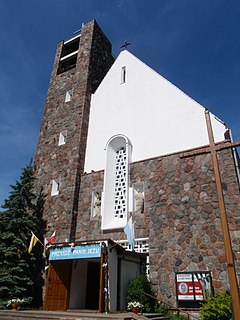
Głowaczów is a village in Kozienice County, Masovian Voivodeship, in east-central Poland. It is the seat of the gmina called Gmina Głowaczów. It lies in northern part of historic Lesser Poland, approximately 18 kilometres (11 mi) west of Kozienice and 71 km (44 mi) south of Warsaw, along National Road Nr. 48. The village has a population of 780.
Grabnowola is a village in the administrative district of Gmina Głowaczów, within Kozienice County, Masovian Voivodeship, in east-central Poland. It lies approximately 12 kilometres (7 mi) north of Głowaczów, 26 km (16 mi) north-west of Kozienice, and 59 km (37 mi) south of Warsaw.
Ignacówka is a village in the administrative district of Gmina Głowaczów, within Kozienice County, Masovian Voivodeship, in east-central Poland. It lies approximately 6 kilometres (4 mi) south of Głowaczów, 19 km (12 mi) west of Kozienice, and 76 km (47 mi) south of Warsaw.
Lipa is a village in the administrative district of Gmina Głowaczów, within Kozienice County, Masovian Voivodeship, in east-central Poland. It lies approximately 4 kilometres (2 mi) north-west of Głowaczów, 21 km (13 mi) west of Kozienice, and 68 km (42 mi) south of Warsaw.
Lipska Wola is a village in the administrative district of Gmina Głowaczów, within Kozienice County, Masovian Voivodeship, in east-central Poland. It lies approximately 5 kilometres (3 mi) west of Głowaczów, 23 km (14 mi) west of Kozienice, and 67 km (42 mi) south of Warsaw.
Łukawska Wola is a village in the administrative district of Gmina Głowaczów, within Kozienice County, Masovian Voivodeship, in east-central Poland. It lies approximately 5 kilometres (3 mi) south-west of Głowaczów, 20 km (12 mi) west of Kozienice, and 73 km (45 mi) south of Warsaw.
Wólka Brzózka is a village in the administrative district of Gmina Głowaczów, within Kozienice County, Masovian Voivodeship, in east-central Poland. It lies approximately 5 kilometres (3 mi) south of Głowaczów, 17 km (11 mi) west of Kozienice, and 74 km (46 mi) south of Warsaw.
Bobrowska may refer to the following villages in Poland: