Gmina Krynki

Last updated
Gmina Krynki
Krynki Commune
Gmina
POL gmina Krynki COA.svg
Coat of arms
POL powiat sokolski gmina Krynki.svg
Gmina Krynki within the Sokółka County
Coordinates(Krynki): 53°16′N23°47′E / 53.267°N 23.783°E / 53.267; 23.783 Coordinates: 53°16′N23°47′E / 53.267°N 23.783°E / 53.267; 23.783
CountryFlag of Poland.svg  Poland
Voivodeship Podlaskie
County Sokółka
Seat Krynki
Area
  Total 165.91 km2 (64.06 sq mi)
Population (2006)
  Total 3,423
  Density 21/km2 (53/sq mi)

Gmina Krynki is an urban-rural gmina (administrative district) in Sokółka County, Podlaskie Voivodeship, in north-eastern Poland, on the border with Belarus. Its seat is the town of Krynki, which lies approximately 24 kilometres (15 mi) south-east of Sokółka and 45 km (28 mi) east of the regional capital Białystok. (Krynki gained town status on 1 January 2009 – prior to that the district was classed as a rural gmina.)

Gmina administrative division of Poland

The gmina is the principal unit of the administrative division of Poland, similar to a municipality. As of 2010 there were 2,478 gminy throughout the country. The word gmina derives from the German word Gemeinde, meaning "community".

Sokółka County County in Podlaskie, Poland

Sokółka County is a unit of territorial administration and local government (powiat) in Podlaskie Voivodeship, north-eastern Poland, on the border with Belarus. It was created on 1 January 1999 as a result of the Polish local government reforms passed in 1998. Its administrative seat and largest town is Sokółka, which lies 39 kilometres (24 mi) north-east of the regional capital Białystok. The county also contains the towns of Dąbrowa Białostocka, lying 30 km (19 mi) north of Sokółka, Krynki, lying 24 km (15 mi) south-east of Sokółka, and Suchowola, 33 km (21 mi) north-west of Sokółka.

Podlaskie Voivodeship Voivodeship in Poland

Podlaskie Voivodeship or Podlasie Province is a voivodeship (province) in northeastern Poland. It borders on Masovian Voivodeship to the west, Warmian-Masurian Voivodeship to the northwest, Lublin Voivodeship to the south, the Belarusian Voblasts of Grodno and Brest to the east, the Lithuanian Counties of Alytus and Marijampolė to the northeast, and the Kaliningrad Oblast of Russia to the north.

Contents

The gmina covers an area of 165.91 square kilometres (64.1 sq mi), and as of 2006 its total population is 3,423, out of which the population of Krynki is 2,709.

The gmina contains part of the protected area called Knyszyń Forest Landscape Park.

Protected area location which receives protection because of its recognised natural, ecological or cultural landscape values

Protected areas or conservation areas are locations which receive protection because of their recognized natural, ecological or cultural values. There are several kinds of protected areas, which vary by level of protection depending on the enabling laws of each country or the regulations of the international organizations involved.

Villages

Apart from the town of Krynki, the gmina contains the villages and settlements of Aleksandrówka, Białogorce, Borsukowizna, Chłodne Włóki, Ciumicze, Górany, Górka, Jamasze, Jurowlany, Kłyszawka, Kruszyniany, Kundzicze, Łapicze, Leszczany, Łosiniany, Nietupa, Nietupa-Kolonia, Nietupskie, Nowa Grzybowszczyzna, Nowa Świdziałówka, Ostrów Południowy, Ozierany Małe, Ozierany Wielkie, Ozierskie, Plebanowo, Podlipki, Podszaciły, Rachowik, Rudaki, Sanniki, Seroczyńszczyzna, Słobódka, Stara Grzybowszczyzna, Studzianka, Szaciły, Trejgle and Żylicze.

Aleksandrówka, Gmina Krynki Settlement in Podlaskie, Poland

Aleksandrówka is a settlement in the administrative district of Gmina Krynki, within Sokółka County, Podlaskie Voivodeship, in north-eastern Poland, close to the border with Belarus. It lies approximately 4 kilometres (2 mi) north-west of Krynki, 21 km (13 mi) south-east of Sokółka, and 44 km (27 mi) north-east of the regional capital Białystok.

Białogorce is a village in the administrative district of Gmina Krynki, within Sokółka County, Podlaskie Voivodeship, in north-eastern Poland, close to the border with Belarus.

Borsukowizna, Sokółka County Village in Podlaskie, Poland

Borsukowizna is a village in the administrative district of Gmina Krynki, within Sokółka County, Podlaskie Voivodeship, in north-eastern Poland, close to the border with Belarus. It lies approximately 11 kilometres (7 mi) south-west of Krynki, 23 km (14 mi) south-east of Sokółka, and 35 km (22 mi) east of the regional capital Białystok.

Neighbouring gminas

Gmina Krynki is bordered by the gminas of Gródek and Szudziałowo. It also borders Belarus.

Gmina Gródek Gmina in Podlaskie, Poland

Gmina Gródek is a rural gmina in Białystok County, Podlaskie Voivodeship, in north-eastern Poland, on the border with Belarus. Its seat is the village of Gródek, which lies approximately 33 kilometres (21 mi) east of the regional capital Białystok.

Gmina Szudziałowo Gmina in Podlaskie, Poland

Gmina Szudziałowo is a rural gmina in Sokółka County, Podlaskie Voivodeship, in north-eastern Poland, on the border with Belarus. Its seat is the village of Szudziałowo, which lies approximately 16 kilometres (10 mi) south-east of Sokółka and 40 km (25 mi) north-east of the regional capital Białystok.

Belarus country in Eastern Europe

Belarus, officially the Republic of Belarus, formerly known by its Russian name Byelorussia or Belorussia, is a landlocked country in Eastern Europe bordered by Russia to the northeast, Ukraine to the south, Poland to the west, and Lithuania and Latvia to the northwest. Its capital and most populous city is Minsk. Over 40% of its 207,600 square kilometres (80,200 sq mi) is forested. Its major economic sectors are service industries and manufacturing. Until the 20th century, different states at various times controlled the lands of modern-day Belarus, including the Principality of Polotsk, the Grand Duchy of Lithuania, the Polish–Lithuanian Commonwealth, and the Russian Empire.

Related Research Articles

Białystok County County in Podlaskie, Poland

Białystok County is a unit of territorial administration and local government (powiat) in Podlaskie Voivodeship, north-eastern Poland, on the border with Belarus. It was created on 1 January 1999 as a result of the Polish local government reforms passed in 1998. Its administrative seat is the city of Białystok, although the city is not part of the county. The county contains nine towns: Łapy, 25 km (16 mi) south-west of Białystok, Czarna Białostocka, 22 km (14 mi) north of Białystok, Wasilków, 11 km (7 mi) north of Białystok, Choroszcz, 13 km (8 mi) west of Białystok, Supraśl, 16 km (10 mi) north-east of Białystok, Michałowo, 13 km (8 mi) east of Białystok, Zabłudów, 16 km (10 mi) south-east of Białystok, Tykocin, 29 km (18 mi) west of Białystok, and Suraż, 23 km (14 mi) south-west of Białystok.

Gmina Michałowo Gmina in Podlaskie, Poland

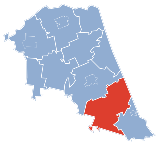
Gmina Michałowo is an urban-rural gmina in Białystok County, Podlaskie Voivodeship, in north-eastern Poland, on the border with Belarus. Its seat is the town of Michałowo, which lies approximately 31 kilometres (19 mi) east of the regional capital Białystok.

Augustów County County in Podlaskie, Poland

Augustów County is a unit of territorial administration and local government (powiat) in Podlaskie Voivodeship, north-eastern Poland, on the border with Belarus. It came into being on January 1, 1999, as a result of the Polish local government reforms passed in 1998. Its administrative seat and largest city is Augustów, which lies 83 kilometres (52 mi) north of the regional capital Białystok. The only other town in the county is Lipsk, lying 32 km (20 mi) south-east of Augustów.

Podlipki Village in Podlaskie, Poland

Podlipki is a village in the administrative district of Gmina Krynki, within Sokółka County, Podlaskie Voivodeship, in north-eastern Poland, close to the border with Belarus. It lies approximately 11 kilometres (7 mi) south-west of Krynki, 24 km (15 mi) south-east of Sokółka, and 35 km (22 mi) east of the regional capital Białystok.

Gmina Bytom Odrzański is an urban-rural gmina in Nowa Sól County, Lubusz Voivodeship, in western Poland. Its seat is the town of Bytom Odrzański, which lies approximately 11 kilometres (7 mi) south-east of Nowa Sól and 32 km (20 mi) south-east of Zielona Góra.

Gmina Sokółka Gmina in Podlaskie, Poland

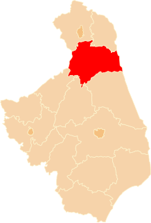
Gmina Sokółka is an urban-rural gmina in Sokółka County, Podlaskie Voivodeship, in north-eastern Poland, on the border with Belarus. Its seat is the town of Sokółka, which lies approximately 39 kilometres (24 mi) north-east of the regional capital Białystok.

Gmina Dąbrowa Białostocka Gmina in Podlaskie, Poland

Gmina Dąbrowa Białostocka is an urban-rural gmina in Sokółka County, Podlaskie Voivodeship, in north-eastern Poland. Its seat is the town of Dąbrowa Białostocka, which lies approximately 30 kilometres (19 mi) north of Sokółka and 61 km (38 mi) north of the regional capital Białystok.

Gmina Kuźnica Gmina in Podlaskie, Poland

Gmina Kuźnica is a rural gmina in Sokółka County, Podlaskie Voivodeship, in north-eastern Poland, on the border with Belarus. Its seat is the village of Kuźnica, which lies approximately 16 kilometres (10 mi) north-east of Sokółka and 54 km (34 mi) north-east of the regional capital Białystok.

Gmina Nowy Dwór Gmina in Podlaskie, Poland

Gmina Nowy Dwór is a rural gmina in Sokółka County, Podlaskie Voivodeship, in north-eastern Poland, on the border with Belarus. Its seat is the village of Nowy Dwór, which lies approximately 27 kilometres (17 mi) north of Sokółka and 63 km (39 mi) north-east of the regional capital Białystok.

Gmina Suchowola Gmina in Podlaskie, Poland

Gmina Suchowola is an urban-rural gmina in Sokółka County, Podlaskie Voivodeship, in north-eastern Poland. Its seat is the town of Suchowola, which lies approximately 33 kilometres (21 mi) north-west of Sokółka and 52 km (32 mi) north of the regional capital Białystok.

Gmina Pasłęk is an urban-rural gmina in Elbląg County, Warmian-Masurian Voivodeship, in northern Poland. Its seat is the town of Pasłęk, which lies approximately 18 kilometres (11 mi) east of Elbląg and 63 km (39 mi) north-west of the regional capital Olsztyn.

Górka, Podlaskie Voivodeship Village in Podlaskie, Poland

Górka is a village in the administrative district of Gmina Krynki, within Sokółka County, Podlaskie Voivodeship, in north-eastern Poland, close to the border with Belarus. It lies approximately 8 kilometres (5 mi) south of Krynki, 30 km (19 mi) south-east of Sokółka, and 43 km (27 mi) east of the regional capital Białystok.

Jurowlany Village in Podlaskie, Poland

Jurowlany is a village in the administrative district of Gmina Krynki, within Sokółka County, Podlaskie Voivodeship, in north-eastern Poland, close to the border with Belarus. It lies approximately 6 kilometres (4 mi) north of Krynki, 20 km (12 mi) south-east of Sokółka, and 46 km (29 mi) north-east of the regional capital Białystok.

Łapicze Village in Podlaskie, Poland

Łapicze is a village in the administrative district of Gmina Krynki, within Sokółka County, Podlaskie Voivodeship, in north-eastern Poland, close to the border with Belarus. It lies approximately 5 kilometres (3 mi) south-east of Krynki, 29 km (18 mi) south-east of Sokółka, and 46 km (29 mi) east of the regional capital Białystok.

Łosiniany Village in Podlaskie, Poland

Łosiniany is a village in the administrative district of Gmina Krynki, within Sokółka County, Podlaskie Voivodeship, in north-eastern Poland, close to the border with Belarus. It lies approximately 10 kilometres (6 mi) south-east of Krynki, 33 km (21 mi) south-east of Sokółka, and 48 km (30 mi) east of the regional capital Białystok.

Stara Grzybowszczyzna Village in Podlaskie, Poland

Stara Grzybowszczyzna is a village in the administrative district of Gmina Krynki, within Sokółka County, Podlaskie Voivodeship, in north-eastern Poland, close to the border with Belarus. It lies approximately 10 kilometres (6 mi) south-west of Krynki, 26 km (16 mi) south-east of Sokółka, and 37 km (23 mi) east of the regional capital Białystok.

Szaciły, Sokółka County Village in Podlaskie, Poland

Szaciły is a village in the administrative district of Gmina Krynki, within Sokółka County, Podlaskie Voivodeship, in north-eastern Poland, close to the border with Belarus. It lies approximately 12 kilometres (7 mi) south of Krynki, 31 km (19 mi) south-east of Sokółka, and 39 km (24 mi) east of the regional capital Białystok.

References