Gmina Szudziałowo

Last updated
Gmina Szudziałowo
Szudziałowo Commune
Gmina
POL gmina Szudzialowo COA.svg
Coat of arms
POL powiat sokolski gmina Szudzialowo.svg
Gmina Szudziałowo within the Sokółka County
Coordinates(Szudziałowo): 53°18′N23°40′E / 53.300°N 23.667°E / 53.300; 23.667 Coordinates: 53°18′N23°40′E / 53.300°N 23.667°E / 53.300; 23.667
CountryFlag of Poland.svg  Poland
Voivodeship Podlaskie
County Sokółka
Seat Szudziałowo
Area
  Total 301.64 km2 (116.46 sq mi)
Population (2006)
  Total 3,419
  Density 11/km2 (29/sq mi)
Website http://www.szudzialowo.nnt.pl/

Gmina Szudziałowo is a rural gmina (administrative district) in Sokółka County, Podlaskie Voivodeship, in north-eastern Poland, on the border with Belarus. Its seat is the village of Szudziałowo, which lies approximately 16 kilometres (10 mi) south-east of Sokółka and 40 km (25 mi) north-east of the regional capital Białystok.

Gmina administrative division of Poland

The gmina is the principal unit of the administrative division of Poland, similar to a municipality. As of 2010 there were 2,478 gminy throughout the country. The word gmina derives from the German word Gemeinde, meaning "community".

Sokółka County County in Podlaskie, Poland

Sokółka County is a unit of territorial administration and local government (powiat) in Podlaskie Voivodeship, north-eastern Poland, on the border with Belarus. It was created on 1 January 1999 as a result of the Polish local government reforms passed in 1998. Its administrative seat and largest town is Sokółka, which lies 39 kilometres (24 mi) north-east of the regional capital Białystok. The county also contains the towns of Dąbrowa Białostocka, lying 30 km (19 mi) north of Sokółka, Krynki, lying 24 km (15 mi) south-east of Sokółka, and Suchowola, 33 km (21 mi) north-west of Sokółka.

Podlaskie Voivodeship Voivodeship in Poland

Podlaskie Voivodeship or Podlasie Province is a voivodeship (province) in northeastern Poland. It borders on Masovian Voivodeship to the west, Warmian-Masurian Voivodeship to the northwest, Lublin Voivodeship to the south, the Belarusian Voblasts of Grodno and Brest to the east, the Lithuanian Counties of Alytus and Marijampolė to the northeast, and the Kaliningrad Oblast of Russia to the north.

Contents

The gmina covers an area of 301.64 square kilometres (116.5 sq mi), and as of 2006 its total population is 3,419.

The gmina contains part of the protected area called Knyszyń Forest Landscape Park.

Protected area location which receives protection because of its recognised natural, ecological or cultural landscape values

Protected areas or conservation areas are locations which receive protection because of their recognized natural, ecological or cultural values. There are several kinds of protected areas, which vary by level of protection depending on the enabling laws of each country or the regulations of the international organizations involved.

Villages

Gmina Szudziałowo contains the villages and settlements of Aleksandrówka, Babiki, Biały Ług, Boratyńszczyzna, Brzozowy Hrud, Chmielowszczyzna, Chmielowszczyzna-Kolonia, Dziewiczy Ług, Grodzisko, Grzybowszczyzna, Hały-Ług, Harkawicze, Horczaki, Iwniki, Jeziorek, Klin, Klin-Gajówka, Knyszewicze, Knyszewicze Małe, Kozłowy Ług, Łaźnisko, Lipowy Most, Litwinowy Ług, Markowy Wygon, Minkowce, Miszkieniki Małe, Miszkieniki Wielkie, Nowe Trzciano, Nowinka, Nowy Ostrów, Ostrów Północny, Ostrówek, Pierekał, Pierożki, Pisarzowce, Poczopek, Rowek, Samogród, Słoja, Słójka, Słójka-Borowszczyzna, Sosnowik, Stare Trzciano, Suchy Hrud, Suchynicze, Sukowicze, Szczęsnowicze, Szudziałowo, Talkowszczyzna, Tołkacze, Usnarz Górny, Wierzchlesie, Wojnowce, Zubowszczyzna, Zubrzyca Mała and Zubrzyca Wielka.

Aleksandrówka is a village in the administrative district of Gmina Szudziałowo, within Sokółka County, Podlaskie Voivodeship, in north-eastern Poland, close to the border with Belarus.

Babiki Village in Podlaskie, Poland

Babiki is a village in the administrative district of Gmina Szudziałowo, within Sokółka County, Podlaskie Voivodeship, in north-eastern Poland, close to the border with Belarus. It lies approximately 9 kilometres (6 mi) north-east of Szudziałowo, 15 km (9 mi) east of Sokółka, and 46 km (29 mi) north-east of the regional capital Białystok.

Biały Ług is a village in the administrative district of Gmina Szudziałowo, within Sokółka County, Podlaskie Voivodeship, in north-eastern Poland, close to the border with Belarus.

Neighbouring gminas

Gmina Szudziałowo is bordered by the gminas of Gródek, Krynki, Sokółka and Supraśl. It also borders Belarus.

Gmina Gródek Gmina in Podlaskie, Poland

Gmina Gródek is a rural gmina in Białystok County, Podlaskie Voivodeship, in north-eastern Poland, on the border with Belarus. Its seat is the village of Gródek, which lies approximately 33 kilometres (21 mi) east of the regional capital Białystok.

Gmina Krynki Gmina in Podlaskie, Poland

Gmina Krynki is an urban-rural gmina in Sokółka County, Podlaskie Voivodeship, in north-eastern Poland, on the border with Belarus. Its seat is the town of Krynki, which lies approximately 24 kilometres (15 mi) south-east of Sokółka and 45 km (28 mi) east of the regional capital Białystok.

Gmina Sokółka Gmina in Podlaskie, Poland

Gmina Sokółka is an urban-rural gmina in Sokółka County, Podlaskie Voivodeship, in north-eastern Poland, on the border with Belarus. Its seat is the town of Sokółka, which lies approximately 39 kilometres (24 mi) north-east of the regional capital Białystok.

Related Research Articles

Gmina Supraśl Gmina in Podlaskie, Poland

Gmina Supraśl is an urban-rural gmina in Białystok County, Podlaskie Voivodeship, in north-eastern Poland. Its seat is the town of Supraśl, which lies approximately 16 kilometres (10 mi) north-east of the regional capital Białystok.

Gmina Kuźnica Gmina in Podlaskie, Poland

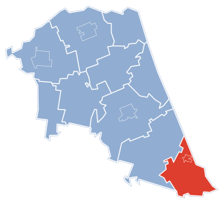
Gmina Kuźnica is a rural gmina in Sokółka County, Podlaskie Voivodeship, in north-eastern Poland, on the border with Belarus. Its seat is the village of Kuźnica, which lies approximately 16 kilometres (10 mi) north-east of Sokółka and 54 km (34 mi) north-east of the regional capital Białystok.

Gmina Nowy Dwór Gmina in Podlaskie, Poland

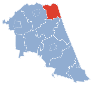
Gmina Nowy Dwór is a rural gmina in Sokółka County, Podlaskie Voivodeship, in north-eastern Poland, on the border with Belarus. Its seat is the village of Nowy Dwór, which lies approximately 27 kilometres (17 mi) north of Sokółka and 63 km (39 mi) north-east of the regional capital Białystok.

Boratyńszczyzna Village in Podlaskie, Poland

Boratyńszczyzna is a village in the administrative district of Gmina Szudziałowo, within Sokółka County, Podlaskie Voivodeship, in north-eastern Poland, close to the border with Belarus. It lies approximately 5 kilometres (3 mi) west of Szudziałowo, 14 km (9 mi) south-east of Sokółka, and 36 km (22 mi) north-east of the regional capital Białystok.

Brzozowy Hrud Village in Podlaskie, Poland

Brzozowy Hrud is a village in the administrative district of Gmina Szudziałowo, within Sokółka County, Podlaskie Voivodeship, in north-eastern Poland, close to the border with Belarus. It lies approximately 12 kilometres (7 mi) west of Szudziałowo, 9 km (6 mi) south of Sokółka, and 33 km (21 mi) north-east of the regional capital Białystok.

Knyszewicze Village in Podlaskie, Poland

Knyszewicze is a village in the administrative district of Gmina Szudziałowo, within Sokółka County, Podlaskie Voivodeship, in north-eastern Poland, close to the border with Belarus. It lies approximately 4 kilometres (2 mi) north of Szudziałowo, 14 km (9 mi) south-east of Sokółka, and 42 km (26 mi) north-east of the regional capital Białystok.

Knyszewicze Małe is a village in the administrative district of Gmina Szudziałowo, within Sokółka County, Podlaskie Voivodeship, in north-eastern Poland, close to the border with Belarus.

Kozłowy Ług Village in Podlaskie, Poland

Kozłowy Ług is a village in the administrative district of Gmina Szudziałowo, within Sokółka County, Podlaskie Voivodeship, in north-eastern Poland, close to the border with Belarus. It lies approximately 5 kilometres (3 mi) west of Szudziałowo, 13 km (8 mi) south-east of Sokółka, and 36 km (22 mi) north-east of the regional capital Białystok.

Markowy Wygon Village in Podlaskie, Poland

Markowy Wygon is a village in the administrative district of Gmina Szudziałowo, within Sokółka County, Podlaskie Voivodeship, in north-eastern Poland, close to the border with Belarus. It lies approximately 6 kilometres (4 mi) south of Szudziałowo, 20 km (12 mi) south-east of Sokółka, and 35 km (22 mi) north-east of the regional capital Białystok.

Miszkieniki Małe is a village in the administrative district of Gmina Szudziałowo, within Sokółka County, Podlaskie Voivodeship, in north-eastern Poland, close to the border with Belarus.

Nowinka, Gmina Szudziałowo Village in Podlaskie, Poland

Nowinka is a village in the administrative district of Gmina Szudziałowo, within Sokółka County, Podlaskie Voivodeship, in north-eastern Poland, close to the border with Belarus. It lies approximately 4 kilometres (2 mi) west of Szudziałowo, 15 km (9 mi) south-east of Sokółka, and 37 km (23 mi) north-east of the regional capital Białystok.

Nowy Ostrów, Podlaskie Voivodeship Village in Podlaskie, Poland

Nowy Ostrów is a village in the administrative district of Gmina Szudziałowo, within Sokółka County, Podlaskie Voivodeship, in north-eastern Poland, close to the border with Belarus. It lies approximately 7 kilometres (4 mi) south of Szudziałowo, 21 km (13 mi) south-east of Sokółka, and 36 km (22 mi) north-east of the regional capital Białystok.

Ostrów Północny Village in Podlaskie, Poland

Ostrów Północny is a village in the administrative district of Gmina Szudziałowo, within Sokółka County, Podlaskie Voivodeship, in north-eastern Poland, close to the border with Belarus. It lies approximately 4 kilometres (2 mi) south of Szudziałowo, 20 km (12 mi) south-east of Sokółka, and 39 km (24 mi) north-east of the regional capital Białystok.

Słójka Village in Podlaskie, Poland

Słójka is a village in the administrative district of Gmina Szudziałowo, within Sokółka County, Podlaskie Voivodeship, in north-eastern Poland, close to the border with Belarus. It lies approximately 4 kilometres (2 mi) west of Szudziałowo, 14 km (9 mi) south-east of Sokółka, and 37 km (23 mi) north-east of the regional capital Białystok.

Stare Trzciano Village in Podlaskie, Poland

Stare Trzciano is a village in the administrative district of Gmina Szudziałowo, within Sokółka County, Podlaskie Voivodeship, in north-eastern Poland, close to the border with Belarus. It lies approximately 7 kilometres (4 mi) south-west of Szudziałowo, 16 km (10 mi) south of Sokółka, and 33 km (21 mi) north-east of the regional capital Białystok.

Szudziałowo Village in Podlaskie, Poland

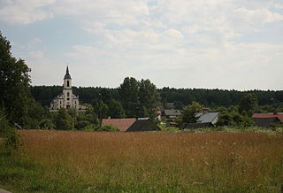
Szudziałowo is a village in Sokółka County, Podlaskie Voivodeship, in north-eastern Poland, close to the border with Belarus. It is the seat of the gmina called Gmina Szudziałowo. It lies approximately 16 kilometres (10 mi) south-east of Sokółka and 40 km (25 mi) north-east of the regional capital Białystok.

Wierzchlesie Village in Podlaskie, Poland

Wierzchlesie is a village in the administrative district of Gmina Szudziałowo, within Sokółka County, Podlaskie Voivodeship, in north-eastern Poland, close to the border with Belarus. It lies approximately 8 kilometres (5 mi) west of Szudziałowo, 10 km (6 mi) south of Sokółka, and 34 km (21 mi) north-east of the regional capital Białystok.

Zubrzyca Mała Village in Podlaskie, Poland

Zubrzyca Mała is a village in the administrative district of Gmina Szudziałowo, within Sokółka County, Podlaskie Voivodeship, in north-eastern Poland, close to the border with Belarus. It lies approximately 11 kilometres (7 mi) north-east of Szudziałowo, 17 km (11 mi) east of Sokółka, and 49 km (30 mi) north-east of the regional capital Białystok.

References