Litwinowy Ług

Last updated
Litwinowy Ług
Village
Country Flag of Poland.svg  Poland
Voivodeship Podlaskie
County Sokółka
Gmina Szudziałowo

Litwinowy Ług [litfiˈnɔvɨ ˈwuk] is a village in the administrative district of Gmina Szudziałowo, within Sokółka County, Podlaskie Voivodeship, in north-eastern Poland, close to the border with Belarus. [1]

Village Small clustered human settlement smaller than a town

A village is a clustered human settlement or community, larger than a hamlet but smaller than a town, with a population ranging from a few hundred to a few thousand. Though villages are often located in rural areas, the term urban village is also applied to certain urban neighborhoods. Villages are normally permanent, with fixed dwellings; however, transient villages can occur. Further, the dwellings of a village are fairly close to one another, not scattered broadly over the landscape, as a dispersed settlement.

Gmina Szudziałowo Gmina in Podlaskie, Poland

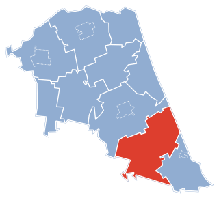
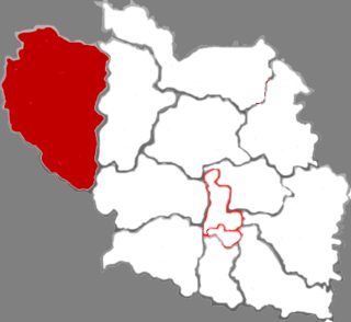
Gmina Szudziałowo is a rural gmina in Sokółka County, Podlaskie Voivodeship, in north-eastern Poland, on the border with Belarus. Its seat is the village of Szudziałowo, which lies approximately 16 kilometres (10 mi) south-east of Sokółka and 40 km (25 mi) north-east of the regional capital Białystok.

Sokółka County County in Podlaskie, Poland

Sokółka County is a unit of territorial administration and local government (powiat) in Podlaskie Voivodeship, north-eastern Poland, on the border with Belarus. It was created on 1 January 1999 as a result of the Polish local government reforms passed in 1998. Its administrative seat and largest town is Sokółka, which lies 39 kilometres (24 mi) north-east of the regional capital Białystok. The county also contains the towns of Dąbrowa Białostocka, lying 30 km (19 mi) north of Sokółka, Krynki, lying 24 km (15 mi) south-east of Sokółka, and Suchowola, 33 km (21 mi) north-west of Sokółka.

Related Research Articles

The Emba River in west Kazakhstan rises in the Mugodzhar Hills and flows some 400 miles (640 km) south-west into the Caspian Sea. It flows through the north of the Ust-Urt plateau, and reaches the Caspian by a series of shallow lagoons, which were navigable in the 18th century. The lower course traverses an area of salt domes and the petroleum-rich Emba fields. It is sometimes regarded as a definition for the natural boundary between Europe and Asia, and was first proposed as such by Philip Johan von Strahlenberg.

Sosnówka, Oleśnica County Village in Lower Silesian, Poland

Sosnówka is a village in the administrative district of Gmina Twardogóra, within Oleśnica County, Lower Silesian Voivodeship, in south-western Poland. Prior to 1945, it was in Germany.

Wiśniowa, Lower Silesian Voivodeship Village in Lower Silesian, Poland

Wiśniowa is a village in the administrative district of Gmina Świdnica, within Świdnica County, Lower Silesian Voivodeship, in south-western Poland. Prior to 1945 it was in Germany.

Our Lady's Children's Hospital, Crumlin in Crumlin, Dublin is Ireland's largest paediatric hospital. It has been caring for Ireland's youth since 1956. It has almost 1200 staff and 243 beds all dedicated to the care of children.

Głowin Village in Kuyavian-Pomeranian, Poland

Głowin is a village in the administrative district of Gmina Zbiczno, within Brodnica County, Kuyavian-Pomeranian Voivodeship, in north-central Poland. It lies 9 kilometres (6 mi) north-west of Zbiczno, 19 km (12 mi) north of Brodnica, and 63 km (39 mi) north-east of Toruń.

Ostrówek is a village in the administrative district of Gmina Sokółka, within Sokółka County, Podlaskie Voivodeship, in north-eastern Poland, close to the border with Belarus.

Dördlər, Xol Qarabucaq Place in Neftchala, Azerbaijan

Dördlər is a village in the Neftchala Rayon of Azerbaijan. The village forms part of the municipality of Xol Qarabucaq.

St Helens Church, Selston Church

St. Helen's Church, Selston is a parish church in the Church of England in Selston, Nottinghamshire.

Dzięglewo is a village in the administrative district of Gmina Sochaczew, within Sochaczew County, Masovian Voivodeship, in east-central Poland.

Biskupiec, Nowe Miasto County Village in Warmian-Masurian, Poland

Biskupiec is a village in Nowe Miasto County, Warmian-Masurian Voivodeship, in northern Poland. It is the seat of the gmina called Gmina Biskupiec.

Sala parish is a territorial unit of the Sala Municipality, Latvia. Prior to 2009, it was part of the Jēkabpils District.

The Fllake transmitter is the largest broadcasting facility in Albania. It is situated at Fllake near Durrës and is the home of several very powerful AM transmitters, which are receivable in the whole of Europe. The facility was built in the communist era as the ARRT-Radio mast, which, with a height of 126 metres, is the highest mast of the station.

Qinyuan County County in Shanxi, Peoples Republic of China

Qinyuan County is a county in the south-central part of Shanxi province, China. It is the westernmost county-level division of Changzhi City.

Beljina, Čačak Village in Moravica District, Serbia

Beljina is a village in the municipality of Čačak, Serbia. According to the 2011 census, the village has a population of 1,086 people.

Kohala-Eesküla is a village in Sõmeru Parish, Lääne-Viru County, in northeastern Estonia.

Voore is a village in Vinni Parish, Lääne-Viru County, in northeastern Estonia.

Täätsi is a village in Saaremaa Parish, Saare County in western Estonia.

Oti, Saare County Village in Saare County, Estonia

Oti is a village in Saaremaa Parish, Saare County in western Estonia.

Glogova (Višegrad) Village in :Template:Country data Republika Bosna I Hercegovina, Bosnia and Herzegovina

Glogova is a village in the municipality of Višegrad, Bosnia and Herzegovina.

Sonans is an unincorporated community in Pittsylvania County, in the U.S. state of Virginia.

References


Coordinates: 53°19′02″N23°30′02″E / 53.31722°N 23.50056°E / 53.31722; 23.50056

Geographic coordinate system Coordinate system

A geographic coordinate system is a coordinate system that enables every location on Earth to be specified by a set of numbers, letters or symbols. The coordinates are often chosen such that one of the numbers represents a vertical position and two or three of the numbers represent a horizontal position; alternatively, a geographic position may be expressed in a combined three-dimensional Cartesian vector. A common choice of coordinates is latitude, longitude and elevation. To specify a location on a plane requires a map projection.