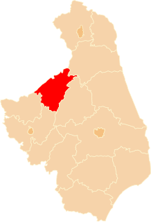
Białystok County is a unit of territorial administration and local government (powiat) in Podlaskie Voivodeship, north-eastern Poland, on the border with Belarus. It was created on 1 January 1999 as a result of the Polish local government reforms passed in 1998. Its administrative seat is the city of Białystok, although the city is not part of the county. The county contains nine towns: Łapy, 25 km (16 mi) south-west of Białystok, Czarna Białostocka, 22 km (14 mi) north of Białystok, Wasilków, 11 km (7 mi) north of Białystok, Choroszcz, 13 km (8 mi) west of Białystok, Supraśl, 16 km (10 mi) north-east of Białystok, Michałowo, 13 km (8 mi) east of Białystok, Zabłudów, 16 km (10 mi) south-east of Białystok, Tykocin, 29 km (18 mi) west of Białystok, and Suraż, 23 km (14 mi) south-west of Białystok.
Augustów County is a unit of territorial administration and local government (powiat) in Podlaskie Voivodeship, north-eastern Poland, on the border with Belarus. It came into being on January 1, 1999, as a result of the Polish local government reforms passed in 1998. Its administrative seat and largest city is Augustów, which lies 83 kilometres (52 mi) north of the regional capital Białystok. The only other town in the county is Lipsk, lying 32 km (20 mi) south-east of Augustów.

Sokółka County is a unit of territorial administration and local government (powiat) in Podlaskie Voivodeship, north-eastern Poland, on the border with Belarus. It was created on 1 January 1999 as a result of the Polish local government reforms passed in 1998. Its administrative seat and largest town is Sokółka, which lies 39 kilometres (24 mi) north-east of the regional capital Białystok. The county also contains the towns of Dąbrowa Białostocka, lying 30 km (19 mi) north of Sokółka, Krynki, lying 24 km (15 mi) south-east of Sokółka, and Suchowola, 33 km (21 mi) north-west of Sokółka.
Grajewo County is a unit of territorial administration and local government (powiat) in Podlaskie Voivodeship, north-eastern Poland. It came into being on January 1, 1999, as a result of the Polish local government reforms passed in 1998. Its administrative seat and largest town is Grajewo, which lies 76 kilometres (47 mi) north-west of the regional capital Białystok. The county also contains the towns of Szczuczyn, lying 15 km (9 mi) south-west of Grajewo, and Rajgród, 19 km (12 mi) north-east of Grajewo.

Łomża County is a unit of territorial administration and local government (powiat) in Podlaskie Voivodeship, north-eastern Poland. It came into being on January 1, 1999, as a result of the Polish local government reforms passed in 1998. Its administrative seat is the city of Łomża, although the city is not part of the county. The only towns in Łomża County are Nowogród, which lies 16 km (10 mi) north-west of Łomża, and Jedwabne, 20 km (12 mi) north-east of Łomża.
Gmina Kutno is a rural gmina in Kutno County, Łódź Voivodeship, in central Poland. Its seat is the town of Kutno, although the town is not part of the territory of the gmina.
Gmina Kobiele Wielkie is a rural gmina in Radomsko County, Łódź Voivodeship, in central Poland. Its seat is the village of Kobiele Wielkie, which lies approximately 13 kilometres (8 mi) east of Radomsko and 84 km (52 mi) south of the regional capital Łódź.
Gmina Trojanów is a rural gmina in Garwolin County, Masovian Voivodeship, in east-central Poland. Its seat is the village of Trojanów, which lies approximately 27 kilometres (16 mi) south-east of Garwolin and 81 km (50 mi) south-east of Warsaw.
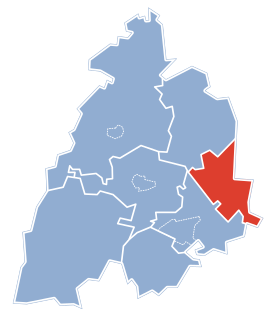
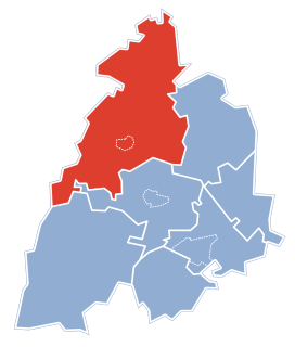
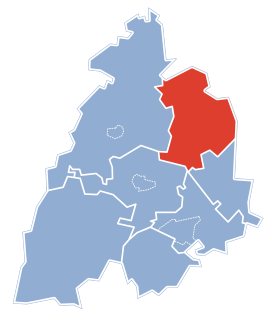
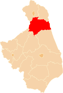
Gmina Jasionówka is a rural gmina in Mońki County, Podlaskie Voivodeship, in north-eastern Poland. Its seat is the village of Jasionówka, which lies approximately 16 kilometres (10 mi) east of Mońki and 33 km (21 mi) north of the regional capital Białystok.
Gmina Krypno is a rural gmina in Mońki County, Podlaskie Voivodeship, in north-eastern Poland. Its seat is the village of Krypno, which lies approximately 15 kilometres (9 mi) south of Mońki and 27 km (17 mi) north-west of the regional capital Białystok.

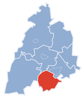
Gmina Trzcianne is a rural gmina in Mońki County, Podlaskie Voivodeship, in north-eastern Poland. Its seat is the village of Trzcianne, which lies approximately 11 kilometres (7 mi) south-west of Mońki and 41 km (25 mi) north-west of the regional capital Białystok.
Gmina Mykanów is a rural gmina in Częstochowa County, Silesian Voivodeship, in southern Poland. Its seat is the village of Mykanów, which lies approximately 14 kilometres (9 mi) north of Częstochowa and 76 km (47 mi) north of the regional capital Katowice.
Gmina Kalinowo is a rural gmina in Ełk County, Warmian-Masurian Voivodeship, in northern Poland. Its seat is the village of Kalinowo, which lies approximately 22 kilometres (14 mi) east of Ełk and 144 km (89 mi) east of the regional capital Olsztyn.
Gmina Świętajno is a rural gmina in Olecko County, Warmian-Masurian Voivodeship, in northern Poland. Its seat is the village of Świętajno, which lies approximately 13 kilometres (8 mi) west of Olecko and 122 km (76 mi) east of the regional capital Olsztyn.

Dudki is a village in the administrative district of Gmina Mońki, within Mońki County, Podlaskie Voivodeship, in north-eastern Poland. It lies approximately 7 kilometres (4 mi) east of Mońki and 35 km (22 mi) north-west of the regional capital Białystok.
Dudki-Kolonia is a village in the administrative district of Gmina Mońki, within Mońki County, Podlaskie Voivodeship, in north-eastern Poland. It lies approximately 8 kilometres (5 mi) east of Mońki and 34 km (21 mi) north-west of the regional capital Białystok.