
Lipsko County is a unit of territorial administration and local government (powiat) in Masovian Voivodeship, east-central Poland. It came into being on January 1, 1999, as a result of the Polish local government reforms passed in 1998. Its administrative seat and only town is Lipsko, which lies 127 kilometres (79 mi) south of Warsaw.

Kraśnik County is a unit of territorial administration and local government (powiat) in Lublin Voivodeship, eastern Poland. It was established on January 1, 1999, as a result of the Polish local government reforms passed in 1998. Its administrative seat and largest town is Kraśnik, which lies 45 kilometres (28 mi) south-west of the regional capital Lublin. The only other town in the county is Annopol, lying 25 km (16 mi) west of Kraśnik.

Opole Lubelskie County is a unit of territorial administration and local government (powiat) in Lublin Voivodeship, eastern Poland. It was established on January 1, 1999, as a result of the Polish local government reforms passed in 1998. Its administrative seat is the town of Opole Lubelskie, which lies 44 kilometres (27 mi) west of the regional capital Lublin. The only other town in the county is Poniatowa, lying 8 km (5 mi) north-east of Opole Lubelskie.
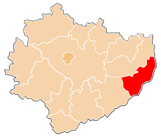
Sandomierz County is a unit of territorial administration and local government (powiat) in Świętokrzyskie Voivodeship, south-central Poland. It came into being on January 1, 1999, as a result of the Polish local government reforms passed in 1998. Its administrative seat and largest town is Sandomierz, which lies 83 kilometres (52 mi) east of the regional capital Kielce. The county also contains the towns of Koprzywnica, lying 16 km (10 mi) south-west of Sandomierz, and Zawichost, 16 km (10 mi) north-east of Sandomierz.
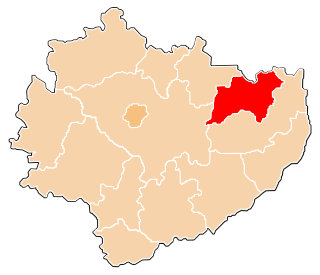
Ostrowiec County is a unit of territorial administration and local government (powiat) in Świętokrzyskie Voivodeship, south-central Poland. It came into being on January 1, 1999, as a result of the Polish local government reforms passed in 1998. Its administrative seat and largest town is Ostrowiec Świętokrzyski, which lies 56 kilometres (35 mi) east of the regional capital Kielce. The county also contains the towns of Ćmielów, lying 10 km (6 mi) south-east of Ostrowiec Świętokrzyski, and Kunów, 9 km (6 mi) west of Ostrowiec Świętokrzyski.
Gmina Piątek is a rural gmina in Łęczyca County, Łódź Voivodeship, in central Poland. Its seat is the village of Piątek, which lies approximately 20 kilometres (12 mi) east of Łęczyca and 32 km (20 mi) north of the regional capital Łódź.
Gmina Kłobuck is an urban-rural gmina in Kłobuck County, Silesian Voivodeship, in southern Poland. Its seat is the town of Kłobuck, which lies approximately 75 kilometres (47 mi) north of the regional capital Katowice.
Gmina Krzepice is an urban-rural gmina in Kłobuck County, Silesian Voivodeship, in southern Poland. Its seat is the town of Krzepice, which lies approximately 16 kilometres (10 mi) west of Kłobuck and 82 km (51 mi) north of the regional capital Katowice.
Gmina Opatów is a rural gmina in Kłobuck County, Silesian Voivodeship, in southern Poland. Its seat is the village of Opatów, which lies approximately 10 kilometres (6 mi) north-west of Kłobuck and 80 km (50 mi) north of the regional capital Katowice.
Gmina Lipnik is a rural gmina in Opatów County, Świętokrzyskie Voivodeship, in south-central Poland. Its seat is the village of Lipnik, which lies approximately 10 kilometres (6 mi) south-east of Opatów and 64 km (40 mi) east of the regional capital Kielce.
Gmina Ożarów is an urban-rural gmina in Opatów County, Świętokrzyskie Voivodeship, in south-central Poland. Its seat is the town of Ożarów, which lies approximately 20 kilometres (12 mi) north-east of Opatów and 74 km (46 mi) east of the regional capital Kielce.
Gmina Sadowie is a rural gmina in Opatów County, Świętokrzyskie Voivodeship, in south-central Poland. Its seat is the village of Sadowie, which lies approximately 7 kilometres (4 mi) north-west of Opatów and 54 km (34 mi) east of the regional capital Kielce.
Gmina Wojciechowice is a rural gmina in Opatów County, Świętokrzyskie Voivodeship, in south-central Poland. Its seat is the village of Wojciechowice, which lies approximately 13 kilometres (8 mi) east of Opatów and 69 km (43 mi) east of the regional capital Kielce.
Gmina Myślibórz is an urban-rural gmina in Myślibórz County, West Pomeranian Voivodeship, in north-western Poland. Its seat is the town of Myślibórz, which lies approximately 57 kilometres (35 mi) south of the regional capital Szczecin.

Czerników Karski is a village in the administrative district of Gmina Opatów, within Opatów County, Świętokrzyskie Voivodeship, in south-central Poland. It lies approximately 4 kilometres (2 mi) south-west of Opatów and 56 km (35 mi) east of the regional capital Kielce.
Czerników Opatowski is a village in the administrative district of Gmina Opatów, within Opatów County, Świętokrzyskie Voivodeship, in south-central Poland. It lies approximately 4 kilometres (2 mi) south-west of Opatów and 56 km (35 mi) east of the regional capital Kielce.
Okalina-Kolonia is a village in the administrative district of Gmina Opatów, within Opatów County, Świętokrzyskie Voivodeship, in south-central Poland. It lies approximately 4 kilometres (2 mi) south of Opatów and 59 km (37 mi) east of the regional capital Kielce.


