Gmina Stawiski

Last updated
Gmina Stawiski
Stawiski Commune
Gmina
Stawiski Herb.svg
Coat of arms
POL powiat kolnenski gmina Stawiski.svg
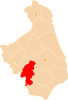
Gmina Stawiski within the Kolno County
Coordinates(Stawiski): 53°22′N22°9′E / 53.367°N 22.150°E / 53.367; 22.150 Coordinates: 53°22′N22°9′E / 53.367°N 22.150°E / 53.367; 22.150
CountryFlag of Poland.svg  Poland
Voivodeship Podlaskie
County Kolno
Seat Stawiski
Area
  Total 165.55 km2 (63.92 sq mi)
Population (2011 [1] )
  Total 6,540
  Density 40/km2 (100/sq mi)
   Urban 2,441
  Rural 4,099
Website http://www.stawiski.pl

Gmina Stawiski is an urban-rural gmina (administrative district) in Kolno County, Podlaskie Voivodeship, in north-eastern Poland. Its seat is the town of Stawiski, which lies approximately 16 kilometres (10 mi) east of Kolno and 74 km (46 mi) west of the regional capital Białystok.

Gmina administrative division of Poland

The gmina is the principal unit of the administrative division of Poland, similar to a municipality. As of 2010 there were 2,478 gminy throughout the country. The word gmina derives from the German word Gemeinde, meaning "community".

Kolno County County in Podlaskie, Poland

Kolno County is a unit of territorial administration and local government (powiat) in Podlaskie Voivodeship, north-eastern Poland. It came into being on January 1, 1999, as a result of the Polish local government reforms passed in 1998. Its administrative seat and largest town is Kolno, which lies 89 kilometres (55 mi) west of the regional capital Białystok. The only other town in the county is Stawiski, lying 16 km (10 mi) east of Kolno.

Podlaskie Voivodeship Voivodeship in Poland

Podlaskie Voivodeship or Podlasie Province is a voivodeship (province) in northeastern Poland. It borders on Masovian Voivodeship to the west, Warmian-Masurian Voivodeship to the northwest, Lublin Voivodeship to the south, the Belarusian Voblasts of Grodno and Brest to the east, the Lithuanian Counties of Alytus and Marijampolė to the northeast, and the Kaliningrad Oblast of Russia to the north.

Contents

The gmina covers an area of 165.55 square kilometres (63.9 sq mi), and as of 2006 its total population is 6,572 (out of which the population of Stawiski amounts to 2,442, and the population of the rural part of the gmina is 4,130).

Villages

Apart from the town of Stawiski, Gmina Stawiski contains the villages and settlements of Barzykowo, Budy Poryckie, Budy Stawiskie, Budziski, Cedry, Chmielewo, Cwaliny, Dąbrowa, Dzięgiele, Dzierzbia, Grabówek, Hipolitowo, Ignacewo, Jewilin, Jurzec Szlachecki, Jurzec Włościański, Karwowo, Kuczyny, Lisy, Łojewek, Michny, Mieczki-Sucholaszczki, Mieszołki, Poryte, Poryte Małe, Poryte Szlacheckie, Poryte Włościańskie, Ramoty, Rogale, Romany, Rostki, Skroda Mała, Sokoły, Tafiły, Wilczewo, Wysokie Duże, Wysokie Małe, Zabiele, Zaborowo, Zalesie and Żelazki.

Barzykowo Village in Podlaskie, Poland

Barzykowo is a village in the administrative district of Gmina Stawiski, within Kolno County, Podlaskie Voivodeship, in north-eastern Poland. It lies approximately 5 kilometres (3 mi) north-west of Stawiski, 13 km (8 mi) east of Kolno, and 77 km (48 mi) north-west of the regional capital Białystok.

Budy Poryckie Village in Podlaskie, Poland

Budy Poryckie is a village in the administrative district of Gmina Stawiski, within Kolno County, Podlaskie Voivodeship, in north-eastern Poland. It lies approximately 4 kilometres (2 mi) south-west of Stawiski, 13 km (8 mi) south-east of Kolno, and 76 km (47 mi) west of the regional capital Białystok.

Budy Stawiskie Village in Podlaskie, Poland

Budy Stawiskie is a village in the administrative district of Gmina Stawiski, within Kolno County, Podlaskie Voivodeship, in north-eastern Poland. It lies approximately 5 kilometres (3 mi) south-west of Stawiski, 15 km (9 mi) south-east of Kolno, and 74 km (46 mi) west of the regional capital Białystok.

Neighbouring gminas

Gmina Stawiski is bordered by the gminas of Grabowo, Jedwabne, Kolno, Mały Płock, Piątnica and Przytuły.

Gmina Grabowo Gmina in Podlaskie, Poland

Gmina Grabowo is a rural gmina in Kolno County, Podlaskie Voivodeship, in north-eastern Poland. Its seat is the village of Grabowo, which lies approximately 15 kilometres (9 mi) east of Kolno and 78 km (48 mi) north-west of the regional capital Białystok.

Gmina Jedwabne Gmina in Podlaskie, Poland

Gmina Jedwabne is an urban-rural gmina in Łomża County, Podlaskie Voivodeship, in north-eastern Poland. Its seat is the town of Jedwabne, which lies approximately 20 kilometres (12 mi) north-east of Łomża and 61 km (38 mi) west of the regional capital Białystok.

Gmina Kolno, Podlaskie Voivodeship Gmina in Podlaskie, Poland

Gmina Kolno is a rural gmina in Kolno County, Podlaskie Voivodeship, in north-eastern Poland. Its seat is the town of Kolno, although the town is not part of the territory of the gmina.

Related Research Articles

Wysokie Mazowieckie County County in Podlaskie, Poland

Wysokie Mazowieckie County is a unit of territorial administration and local government (powiat) in Podlaskie Voivodeship, north-eastern Poland. It came into being on January 1, 1999, as a result of the Polish local government reforms passed in 1998. Its administrative seat and largest town is Wysokie Mazowieckie, which lies 49 kilometres (30 mi) south-west of the regional capital Białystok. The only other towns in the county are Ciechanowiec, lying 27 km (17 mi) south of Wysokie, Szepietowo, 6 km (4 mi) south of Wysokie, and as from 1 January 2011 Czyżew.

Gmina Czerwieńsk Gmina in Lubusz, Poland

Gmina Czerwieńsk is an urban-rural gmina in Zielona Góra County, Lubusz Voivodeship, in western Poland. Its seat is the town of Czerwieńsk, which lies approximately 11 kilometres (7 mi) north-west of Zielona Góra.

Gmina Puszcza Mariańska is a rural gmina in Żyrardów County, Masovian Voivodeship, in east-central Poland. Its seat is the village of Puszcza Mariańska, which lies approximately 10 kilometres (6 mi) south-west of Żyrardów and 52 km (32 mi) south-west of Warsaw.

Gmina Mały Płock Gmina in Podlaskie, Poland

Gmina Mały Płock is a rural gmina in Kolno County, Podlaskie Voivodeship, in north-eastern Poland. Its seat is the village of Mały Płock, which lies approximately 14 kilometres (9 mi) south-east of Kolno and 80 km (50 mi) west of the regional capital Białystok.

Gmina Piątnica Gmina in Podlaskie, Poland

Gmina Piątnica is a rural gmina in Łomża County, Podlaskie Voivodeship, in north-eastern Poland. Its seat is the village of Piątnica, which lies approximately 3 kilometres (2 mi) north-east of Łomża and 72 km (45 mi) west of the regional capital Białystok.

Gmina Nowe Piekuty is a rural gmina in Wysokie Mazowieckie County, Podlaskie Voivodeship, in north-eastern Poland. Its seat is the village of Nowe Piekuty, which lies approximately 15 kilometres (9 mi) south-east of Wysokie Mazowieckie and 43 km (27 mi) south-west of the regional capital Białystok.

Gmina Zambrów is a rural gmina in Zambrów County, Podlaskie Voivodeship, in north-eastern Poland. Its seat is the town of Zambrów, although the town is not part of the territory of the gmina. Its largest village is Wola Zambrowska.

Gmina Jastrowie is an urban-rural gmina in Złotów County, Greater Poland Voivodeship, in west-central Poland. Its seat is the town of Jastrowie, which lies approximately 17 kilometres (11 mi) north-west of Złotów and 114 km (71 mi) north of the regional capital Poznań.

Poryte Village in Podlaskie, Poland

Poryte is a village in the administrative district of Gmina Stawiski, within Kolno County, Podlaskie Voivodeship, in north-eastern Poland. It lies approximately 6 kilometres (4 mi) west of Stawiski, 12 km (7 mi) south-east of Kolno, and 78 km (48 mi) west of the regional capital Białystok.

Poryte Małe is a village in the administrative district of Gmina Stawiski, within Kolno County, Podlaskie Voivodeship, in north-eastern Poland.

Poryte Szlacheckie Village in Podlaskie, Poland

Poryte Szlacheckie is a village in the administrative district of Gmina Stawiski, within Kolno County, Podlaskie Voivodeship, in north-eastern Poland. It lies approximately 6 kilometres (4 mi) west of Stawiski, 12 km (7 mi) south-east of Kolno, and 78 km (48 mi) west of the regional capital Białystok.

Poryte Włościańskie Village in Podlaskie, Poland

Poryte Włościańskie is a village in the administrative district of Gmina Stawiski, within Kolno County, Podlaskie Voivodeship, in north-eastern Poland. It lies approximately 6 kilometres (4 mi) west of Stawiski, 12 km (7 mi) south-east of Kolno, and 78 km (48 mi) west of the regional capital Białystok.

Wysokie Duże Village in Podlaskie, Poland

Wysokie Duże is a village in the administrative district of Gmina Stawiski, within Kolno County, Podlaskie Voivodeship, in north-eastern Poland. It lies approximately 10 kilometres (6 mi) south of Stawiski, 18 km (11 mi) south-east of Kolno, and 74 km (46 mi) west of the regional capital Białystok.

Wysokie Małe Village in Podlaskie, Poland

Wysokie Małe is a village in the administrative district of Gmina Stawiski, within Kolno County, Podlaskie Voivodeship, in north-eastern Poland. It lies approximately 8 kilometres (5 mi) south of Stawiski, 18 km (11 mi) south-east of Kolno, and 73 km (45 mi) west of the regional capital Białystok.

References

  1. Demographic Yearbook of Poland 2012