Strzelce-Drezdenko County is a unit of territorial administration and local government (powiat) in Lubusz Voivodeship, western Poland. It came into being on January 1, 1999, as a result of the Polish local government reforms passed in 1998. Its administrative seat is the town of Strzelce Krajeńskie, which lies 25 km (16 mi) north-east of Gorzów Wielkopolski and 104 km (65 mi) north of Zielona Góra. The county also contains the towns of Drezdenko, lying 21 km (13 mi) east of Strzelce Krajeńskie, and Dobiegniew, 18 km (11 mi) north-east of Strzelce Krajeńskie.

Chodzież County is a unit of territorial administration and local government (powiat) in Greater Poland Voivodeship, west-central Poland. It came into being on January 1, 1999, as a result of the Polish local government reforms passed in 1998. Its administrative seat and largest town is Chodzież, which lies 65 kilometres (40 mi) north of the regional capital Poznań. The county also contains the towns of Szamocin, lying 16 km (10 mi) east of Chodzież, and Margonin, 13 km (8 mi) east of Chodzież.

Oborniki County is a unit of territorial administration and local government (powiat) in Greater Poland Voivodeship, west-central Poland. It came into being on January 1, 1999, as a result of the Polish local government reforms passed in 1998. Its administrative seat and largest town is Oborniki, which lies 29 kilometres (18 mi) north of the regional capital Poznań. The only other town in the county is Rogoźno, lying 17 km (11 mi) north-east of Oborniki.

Szamotuły County is a unit of territorial administration and local government (powiat) in Greater Poland Voivodeship, west-central Poland. It came into existence on January 1, 1999, as a result of the Polish local government reforms passed in 1998. Its administrative seat and largest town is Szamotuły, which lies 32 kilometres (20 mi) north-west of the regional capital Poznań. The county contains four other towns: Wronki, 18 km (11 mi) north-west of Szamotuły, Pniewy, 24 km (15 mi) south-west of Szamotuły, Obrzycko, 13 km (8 mi) north of Szamotuły, and Ostroróg, 9 km (6 mi) north-west of Szamotuły.

Międzychód County is a unit of territorial administration and local government (powiat) in Greater Poland Voivodeship, west-central Poland. It came into being on January 1, 1999, as a result of the Polish local government reforms passed in 1998. Its administrative seat and largest town is Międzychód, which lies 74 kilometres (46 mi) west of the regional capital Poznań. The only other town in the county is Sieraków, lying 16 km (10 mi) east of Międzychód.
Wałcz County is a unit of territorial administration and local government (powiat) in West Pomeranian Voivodeship, north-western Poland. It came into being on January 1, 1999, as a result of the Polish local government reforms passed in 1998. Its administrative seat and largest town is Wałcz, which lies 127 kilometres (79 mi) east of the regional capital Szczecin. The county contains three other towns: Mirosławiec, 27 km (17 mi) west of Wałcz, Człopa, 31 km (19 mi) south-west of Wałcz, and Tuczno, 25 km (16 mi) south-west of Wałcz.
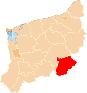
Gmina Drawsko is a rural gmina in Czarnków-Trzcianka County, Greater Poland Voivodeship, in west-central Poland. Its seat is the village of Drawsko, which lies approximately 37 kilometres (23 mi) west of Czarnków and 78 km (48 mi) north-west of the regional capital Poznań.
Gmina Krzyż Wielkopolski is an urban-rural gmina in Czarnków-Trzcianka County, Greater Poland Voivodeship, in west-central Poland. Its seat is the town of Krzyż Wielkopolski, which lies approximately 38 kilometres (24 mi) west of Czarnków and 82 km (51 mi) north-west of the regional capital Poznań.
Gmina Lubasz is a rural gmina in Czarnków-Trzcianka County, Greater Poland Voivodeship, in west-central Poland. Its seat is the village of Lubasz, which lies approximately 7 kilometres (4 mi) south-west of Czarnków and 57 km (35 mi) north-west of the regional capital Poznań.
Gmina Połajewo is a rural gmina in Czarnków-Trzcianka County, Greater Poland Voivodeship, in west-central Poland. Its seat is the village of Połajewo, which lies approximately 17 kilometres (11 mi) south-east of Czarnków and 46 km (29 mi) north of the regional capital Poznań.
Gmina Wieleń is an urban-rural gmina in Czarnków-Trzcianka County, Greater Poland Voivodeship, in west-central Poland. Its seat is the town of Wieleń, which lies approximately 27 kilometres (17 mi) west of Czarnków and 75 km (47 mi) north-west of the regional capital Poznań.
Gmina Ujście is an urban-rural gmina in Piła County, Greater Poland Voivodeship, in west-central Poland. Its seat is the town of Ujście, which lies approximately 10 kilometres (6 mi) south of Piła and 75 km (47 mi) north of the regional capital Poznań.

Łomnica is a village in the administrative district of Gmina Trzcianka, within Czarnków-Trzcianka County, Greater Poland Voivodeship, in west-central Poland. It lies approximately 8 kilometres (5 mi) north-east of Trzcianka, 23 km (14 mi) north of Czarnków, and 82 km (51 mi) north of the regional capital Poznań.
Łomnica Pierwsza is a settlement in the administrative district of Gmina Trzcianka, within Czarnków-Trzcianka County, Greater Poland Voivodeship, in west-central Poland.
Łomnica-Folwark is a settlement in the administrative district of Gmina Trzcianka, within Czarnków-Trzcianka County, Greater Poland Voivodeship, in west-central Poland. It lies approximately 7 kilometres (4 mi) north of Trzcianka, 24 km (15 mi) north of Czarnków, and 84 km (52 mi) north of the regional capital Poznań.
Łomnica-Młyn is a settlement in the administrative district of Gmina Trzcianka, within Czarnków-Trzcianka County, Greater Poland Voivodeship, in west-central Poland. It lies approximately 10 kilometres (6 mi) north-east of Trzcianka, 23 km (14 mi) north of Czarnków, and 82 km (51 mi) north of the regional capital Poznań.
Teresin is a village in the administrative district of Gmina Trzcianka, within Czarnków-Trzcianka County, Greater Poland Voivodeship, in west-central Poland. It lies approximately 5 kilometres (3 mi) south-east of Trzcianka, 14 km (9 mi) north of Czarnków, and 74 km (46 mi) north of the regional capital Poznań.
Teresin-Karczma is a settlement in the administrative district of Gmina Trzcianka, within Czarnków-Trzcianka County, Greater Poland Voivodeship, in west-central Poland.