Gmina Zabierzów Zabierzów Commune | ||
---|---|---|
Gmina | ||
| ||
Coordinates(Zabierzów): 50°7′5″N19°46′47″E / 50.11806°N 19.77972°E Coordinates: 50°7′5″N19°46′47″E / 50.11806°N 19.77972°E | ||
Country | ||
Voivodeship | Lesser Poland | |
County | Kraków County | |
Seat | Zabierzów | |
Area | ||
• Total | 99.59 km2 (38.45 sq mi) | |
Population (2006) | ||
• Total | 22,387 | |
• Density | 220/km2 (580/sq mi) | |
Website | http://www.zabierzow.org.pl/ |
Gmina Zabierzów is a rural gmina (administrative district) in Kraków County, Lesser Poland Voivodeship, in southern Poland. Its seat is the village of Zabierzów, which lies approximately 13 kilometres (8 mi) north-west of the regional capital Kraków.
The gmina is the principal unit of the administrative division of Poland, similar to a municipality. As of 2010 there were 2,478 gminy throughout the country. The word gmina derives from the German word Gemeinde, meaning "community".
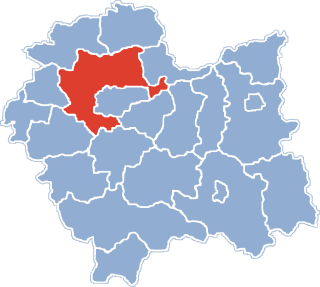
Kraków County is a unit of territorial administration and local government (powiat) in Lesser Poland Voivodeship, southern Poland. It came into being on January 1, 1999, as a result of the Polish local government reforms passed in 1998. Its administrative seat is the city of Kraków, although the city is not part of the county. The county contains five towns: Skawina, 12 km (7 mi) south-west of Kraków, Krzeszowice, 24 km (15 mi) west of Kraków, Słomniki, 24 km (15 mi) north-east of Kraków, Skała, 20 km (12 mi) north of Kraków, and Świątniki Górne, 15 km (9 mi) south of Kraków.
Lesser Poland Voivodeship or Lesser Poland Province, also known as Małopolska Voivodeship or Małopolska Province, is a voivodeship (province), in southern Poland. It has an area of 15,108 square kilometres (5,833 sq mi), and a population of 3,267,731 (2006).
The gmina covers an area of 99.59 square kilometres (38.5 sq mi), and as of 2006 its total population is 22,387.
The gmina contains part of the protected area called Kraków Valleys Landscape Park.
Protected areas or conservation areas are locations which receive protection because of their recognized natural, ecological or cultural values. There are several kinds of protected areas, which vary by level of protection depending on the enabling laws of each country or the regulations of the international organizations involved.
Kraków Valleys Landscape Park is a protected area in southern Poland, covering an area of 197.77 square kilometres (76.36 sq mi). Within the Landscape Park are five nature reserves.
Gmina Zabierzów contains the villages and settlements of Aleksandrowice, Balice, Bolechowice, Brzezie, Brzezinka, Brzoskwinia, Burów, Karniowice, Kleszczów, Kobylany, Kochanów, Młynka, Niegoszowice, Nielepice, Pisary, Radwanowice, Rudawa, Rząska, Szczyglice, Ujazd, Więckowice, Zabierzów and Zelków.
Aleksandrowice is a village in the administrative district of Gmina Zabierzów, within Kraków County, Lesser Poland Voivodeship, in southern Poland. It lies approximately 4 kilometres (2 mi) south of Zabierzów and 13 km (8 mi) west of the regional capital Kraków.
Balice is a village in the administrative district of Gmina Zabierzów, within Kraków County, Lesser Poland Voivodeship, in southern Poland. It lies approximately 4 kilometres (2 mi) south of Zabierzów and 11 km (7 mi) west of the city centre of Kraków.
Bolechowice is a village in the administrative district of Gmina Zabierzów, within Kraków County, Lesser Poland Voivodeship, in southern Poland. It lies approximately 4 kilometres (2 mi) north of Zabierzów and 14 km (9 mi) north-west of the regional capital Kraków.
Gmina Zabierzów is bordered by the city of Kraków and by the gminas of Jerzmanowice-Przeginia, Krzeszowice, Liszki and Wielka Wieś.
Gmina Jerzmanowice-Przeginia is a rural gmina in Kraków County, Lesser Poland Voivodeship, in southern Poland. Its seat is the village of Jerzmanowice, which lies approximately 22 kilometres (14 mi) north-west of the regional capital Kraków.
Gmina Krzeszowice is an urban-rural gmina in Kraków County, Lesser Poland Voivodeship, in southern Poland. Its seat is the town of Krzeszowice, which lies approximately 24 kilometres (15 mi) west of the regional capital Kraków.
Gmina Liszki is a rural gmina in Kraków County, Lesser Poland Voivodeship, in southern Poland. Its seat is the village of Liszki, which lies approximately 13 kilometres (8 mi) west of the regional capital Kraków.
Blazon: a Modern French shield per pale gules and azure, on the first a griffon segreant argent armed, beaked and langued Or, on the second a human figure fully armoured argent holding a heater shield gules charged with two labels Or of three points arranged in pale.
The shield samnitic, also called Modern French shield, appears in the 16th c. is a shield of rectangular shape whose lower corners are rounded as arcs of a circle with a radius of half module. According to some authors it is normally 8 modules high and 7 wide, as the tournament shield, while others report a height of 9 modules and width of 7. The center of the lower side is provided with a tip formed by two arcs of a circle of radius also of the middle module. This shield is also frequently used in heraldry Spanish along with the Spanish shield: some authors, such as the Marquis of Avilés, reported the proportion of a height of 6 modules to 5 modules wide for standard Spanish. The Samnite shield has also been adopted as the official support civic heraldry and Italian military and in this case its official size is 9 × 7.
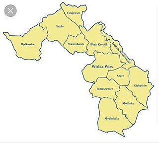
Gmina Wielka Wieś is a rural gmina in Kraków County, Lesser Poland Voivodeship, in southern Poland. Its seat is the village of Wielka Wieś, which lies approximately 13 kilometres (8 mi) north-west of the regional capital Kraków.
Gmina Walce, German Gemeinde Walzen is a rural gmina in Krapkowice County, Opole Voivodeship, in south-western Poland. Its seat is the village of Walce (Walzen), which lies approximately 11 kilometres (7 mi) south of Krapkowice and 34 km (21 mi) south of the regional capital Opole.
Brzezie is a village in the administrative district of Gmina Zabierzów, within Kraków County, Lesser Poland Voivodeship, in southern Poland. It lies approximately 4 kilometres (2 mi) east of Zabierzów and 10 km (6 mi) north-west of the regional capital Kraków.
Brzezinka is a village in the administrative district of Gmina Zabierzów, within Kraków County, Lesser Poland Voivodeship, in southern Poland. It lies approximately 4 kilometres (2 mi) north-west of Zabierzów and 17 km (11 mi) north-west of the regional capital Kraków.
Brzoskwinia is a village in the administrative district of Gmina Zabierzów, within Kraków County, Lesser Poland Voivodeship, in southern Poland. It lies approximately 6 kilometres (4 mi) south-west of Zabierzów and 17 km (11 mi) west of the regional capital Kraków.
Burów is a village in the administrative district of Gmina Zabierzów, within Kraków County, Lesser Poland Voivodeship, in southern Poland. It lies approximately 3 kilometres (2 mi) south-west of Zabierzów and 13 km (8 mi) west of the regional capital Kraków.
Kleszczów is a village in the administrative district of Gmina Zabierzów, within Kraków County, Lesser Poland Voivodeship, in southern Poland. It lies approximately 3 kilometres (2 mi) south-west of Zabierzów and 15 km (9 mi) west of the regional capital Kraków.
Młynka is a village in the administrative district of Gmina Zabierzów, within Kraków County, Lesser Poland Voivodeship, in southern Poland. It lies approximately 8 kilometres (5 mi) west of Zabierzów and 19 km (12 mi) west of the regional capital Kraków.
Pisary is a village in the administrative district of Gmina Zabierzów, within Kraków County, Lesser Poland Voivodeship, in southern Poland. It lies approximately 7 kilometres (4 mi) west of Zabierzów and 19 km (12 mi) north-west of the regional capital Kraków.
Rząska is a village in the administrative district of Gmina Zabierzów, within Kraków County, Lesser Poland Voivodeship, in southern Poland. It lies approximately 5 kilometres (3 mi) south-east of Zabierzów and 9 km (6 mi) north-west of the regional capital Kraków.
Szczyglice is a village in the administrative district of Gmina Zabierzów, within Kraków County, Lesser Poland Voivodeship, in southern Poland. It lies approximately 4 kilometres (2 mi) south-east of Zabierzów and 10 km (6 mi) north-west of the regional capital Kraków.
Ujazd is a village in the administrative district of Gmina Zabierzów, within Kraków County, Lesser Poland Voivodeship, in southern Poland. It lies approximately 4 kilometres (2 mi) north-east of Zabierzów and 12 km (7 mi) north-west of the regional capital Kraków. The village is located in the historical region Galicia.
Więckowice is a village in the administrative district of Gmina Zabierzów, within Kraków County, Lesser Poland Voivodeship, in southern Poland. It lies approximately 2 kilometres (1 mi) north-west of Zabierzów and 15 km (9 mi) north-west of the regional capital Kraków.