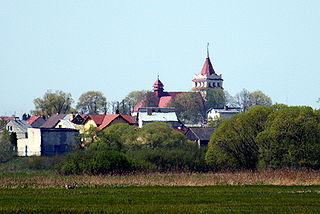
Gmina Łapy

Last updated
Gmina Łapy
Łapy Commune
Gmina
POL Lapy flag.svg
Flag
POL Lapy COA.svg
Coat of arms
Mapa Gmina Lapy.png
Location within Białystok County
Coordinates(Łapy): 52°59′N22°53′E / 52.983°N 22.883°E / 52.983; 22.883 Coordinates: 52°59′N22°53′E / 52.983°N 22.883°E / 52.983; 22.883
CountryFlag of Poland.svg  Poland
Voivodeship Podlaskie
County Białystok County
Seat Łapy
Area
  Total 127.57 km2 (49.26 sq mi)
Population (2006)
  Total 23,132
  Density 180/km2 (470/sq mi)
   Urban 16,583
  Rural 6,549
Website http://www.lapy.podlasie.pl/

Gmina Łapy is an urban-rural gmina (administrative district) in Białystok County, Podlaskie Voivodeship, in north-eastern Poland. Its seat is the town of Łapy, which lies approximately 25 kilometres (16 mi) south-west of the regional capital Białystok.

Gmina administrative division of Poland

The gmina is the principal unit of the administrative division of Poland, similar to a municipality. As of 2010 there were 2,478 gminy throughout the country. The word gmina derives from the German word Gemeinde, meaning "community".
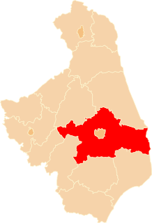
Białystok County County in Podlaskie, Poland

Białystok County is a unit of territorial administration and local government (powiat) in Podlaskie Voivodeship, north-eastern Poland, on the border with Belarus. It was created on 1 January 1999 as a result of the Polish local government reforms passed in 1998. Its administrative seat is the city of Białystok, although the city is not part of the county. The county contains nine towns: Łapy, 25 km (16 mi) south-west of Białystok, Czarna Białostocka, 22 km (14 mi) north of Białystok, Wasilków, 11 km (7 mi) north of Białystok, Choroszcz, 13 km (8 mi) west of Białystok, Supraśl, 16 km (10 mi) north-east of Białystok, Michałowo, 13 km (8 mi) east of Białystok, Zabłudów, 16 km (10 mi) south-east of Białystok, Tykocin, 29 km (18 mi) west of Białystok, and Suraż, 23 km (14 mi) south-west of Białystok.

Podlaskie Voivodeship Voivodeship in Poland

Podlaskie Voivodeship or Podlasie Province is a voivodeship (province) in northeastern Poland. It borders on Masovian Voivodeship to the west, Warmian-Masurian Voivodeship to the northwest, Lublin Voivodeship to the south, the Belarusian Voblasts of Grodno and Brest to the east, the Lithuanian Counties of Alytus and Marijampolė to the northeast, and the Kaliningrad Oblast of Russia to the north.

Contents

The gmina covers an area of 127.57 square kilometres (49.3 sq mi), and as of 2006 its total population is 23,132 (out of which the population of Łapy amounts to 16,583, and the population of the rural part of the gmina is 6,549).

Villages

Apart from the town of Łapy, Gmina Łapy contains the villages and settlements of Bokiny, Daniłowo Duże, Daniłowo Małe, Gąsówka-Oleksin, Gąsówka-Osse, Gąsówka-Skwarki, Gąsówka-Somachy, Łapy-Dębowina, Łapy-Kołpaki, Łapy-Korczaki, Łapy-Łynki, Łapy-Pluśniaki, Łapy-Szołajdy, Nowa Łupianka, Płonka Kościelna, Płonka-Kozły, Płonka-Matyski, Płonka-Strumianka, Roszki-Włodki, Roszki-Wodźki, Stara Gąsówka, Stara Łupianka, Uhowo and Wólka Waniewska.

Bokiny Village in Podlaskie, Poland

Bokiny is a village in the administrative district of Gmina Łapy, within Białystok County, Podlaskie Voivodeship, in north-eastern Poland. It lies approximately 8 kilometres (5 mi) north of Łapy and 19 km (12 mi) south-west of the regional capital Białystok.

Daniłowo Duże Village in Podlaskie, Poland

Daniłowo Duże is a village in the administrative district of Gmina Łapy, within Białystok County, Podlaskie Voivodeship, in north-eastern Poland. It lies approximately 6 kilometres (4 mi) south of Łapy and 28 km (17 mi) south-west of the regional capital Białystok.

Daniłowo Małe Village in Podlaskie, Poland

Daniłowo Małe is a village in the administrative district of Gmina Łapy, within Białystok County, Podlaskie Voivodeship, in north-eastern Poland. It lies approximately 4 kilometres (2 mi) south of Łapy and 27 km (17 mi) south-west of the regional capital Białystok.

Neighbouring gminas

Gmina Łapy is bordered by the gminas of Choroszcz, Poświętne, Sokoły, Suraż and Turośń Kościelna.

Gmina Choroszcz Gmina in Podlaskie, Poland

Gmina Choroszcz is an urban-rural gmina in Białystok County, Podlaskie Voivodeship, in north-eastern Poland. Its seat is the town of Choroszcz, which lies approximately 13 kilometres (8 mi) west of the regional capital Białystok.

Gmina Poświętne, Podlaskie Voivodeship Gmina in Podlaskie, Poland

Gmina Poświętne is a rural gmina in Białystok County, Podlaskie Voivodeship, in north-eastern Poland. Its seat is the village of Poświętne, which lies approximately 32 kilometres (20 mi) south-west of the regional capital Białystok.

Gmina Sokoły is a rural gmina in Wysokie Mazowieckie County, Podlaskie Voivodeship, in north-eastern Poland. Its seat is the village of Sokoły, which lies approximately 15 kilometres (9 mi) north-east of Wysokie Mazowieckie and 35 km (22 mi) south-west of the regional capital Białystok.

Related Research Articles

Białystok Voivodeship (1975–98) unit of administrative division and local government in Poland from 1975 to 1998

See also: Białystok Voivodeship (1919–39) and Białystok Voivodeship

Łapy Place in Podlaskie, Poland

Łapy is a town in north-eastern Poland, in Białystok County (powiat), Podlaskie Voivodeship; the administrative centre of the urban-rural gmina Łapy. It is situated in the North Podlasie Lowland, on the river Narew.

Gmina Czarna Białostocka Gmina in Podlaskie, Poland

Gmina Czarna Białostocka is an urban-rural gmina in Białystok County, Podlaskie Voivodeship, in north-eastern Poland. Its seat is the town of Czarna Białostocka, which lies approximately 22 kilometres (14 mi) north of the regional capital Białystok.

Gmina Turośń Kościelna Gmina in Podlaskie, Poland

Gmina Turośń Kościelna is a rural gmina in Białystok County, Podlaskie Voivodeship, in north-eastern Poland. Its seat is the village of Turośń Kościelna, which lies approximately 13 kilometres (8 mi) south-west of the regional capital Białystok.

Gmina Suraż Gmina in Podlaskie, Poland

Gmina Suraż is an urban-rural gmina in Białystok County, Podlaskie Voivodeship, in north-eastern Poland. Its seat is the town of Suraż, which lies approximately 23 kilometres (14 mi) south-west of the regional capital Białystok.

Gmina Szydłowo is a rural gmina in Mława County, Masovian Voivodeship, in east-central Poland. Its seat is the village of Szydłowo, which lies approximately 6 kilometres (3 mi) south-east of Mława and 102 km (63 mi) north-west of Warsaw.

Gmina Brańsk Gmina in Podlaskie, Poland

Gmina Brańsk is a rural gmina in Bielsk County, Podlaskie Voivodeship. It is located in north-eastern Poland.

Gmina Rudka Gmina in Podlaskie, Poland

Gmina Rudka is a rural gmina in Bielsk County, Podlaskie Voivodeship. It is located in north-eastern Poland.

Gmina Knyszyn Gmina in Podlaskie, Poland

Gmina Knyszyn is an urban-rural gmina in Mońki County, Podlaskie Voivodeship, in north-eastern Poland. Its seat is the town of Knyszyn, which lies approximately 13 kilometres (8 mi) south-east of Mońki and 28 km (17 mi) north-west of the regional capital Białystok.

Gmina Suchowola Gmina in Podlaskie, Poland

Gmina Suchowola is an urban-rural gmina in Sokółka County, Podlaskie Voivodeship, in north-eastern Poland. Its seat is the town of Suchowola, which lies approximately 33 kilometres (21 mi) north-west of Sokółka and 52 km (32 mi) north of the regional capital Białystok.

Gmina Smętowo Graniczne is a rural gmina in Starogard County, Pomeranian Voivodeship, in northern Poland. Its seat is the village of Smętowo Graniczne, which lies approximately 27 kilometres (17 mi) south of Starogard Gdański and 70 km (43 mi) south of the regional capital Gdańsk.

Płonka Kościelna Village in Podlaskie, Poland

Płonka Kościelna is a village in the administrative district of Gmina Łapy, within Białystok County, Podlaskie Voivodeship, in north-eastern Poland. It lies approximately 4 kilometres (2 mi) north-west of Łapy and 26 km (16 mi) south-west of the regional capital Białystok.

Roszki-Włodki Village in Podlaskie, Poland

Roszki-Włodki is a village in the administrative district of Gmina Łapy, within Białystok County, Podlaskie Voivodeship, in north-eastern Poland. It lies approximately 7 kilometres (4 mi) west of Łapy and 29 km (18 mi) south-west of the regional capital Białystok.

Stara Gąsówka is a village in the administrative district of Gmina Łapy, within Białystok County, Podlaskie Voivodeship, in north-eastern Poland.

References