
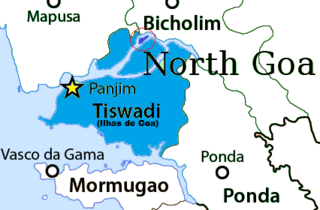
Old Goa is a historical site and city situated on the southern banks of the River Mandovi, within the Tiswadi taluka (Ilhas) of North Goa district, in the Indian state of Goa.

The Mandovi, also known as the Mhadei, is a river described as the lifeline of the Indian state of Goa. The Mandovi and the Zuari are the two principal rivers in the state of Goa. Mandovi joins with the Zuari at a common creek at Cabo Aguada, forming the Mormugao harbour. Panaji, the state capital and Old Goa, the former capital of Goa, are both situated on the left bank of the Mandovi.

The Zuari RiverZuvari, pronounced [zuwəːriː]) is the largest river in the state of Goa, India. It is a tidal river which originates at Hemad-Barshem in the Western Ghats. The Zuari is also referred to as the Aghanashani in the interior regions. It flows in the southern-western direction through the talukas of Tiswadi, Ponda, Mormugao, Salcete, Sanguem and Quepem.

Ribandar is a town in Tiswadi, Goa, located between the cities of Panjim and Old Goa.

Chorão, also known as Choddnnem or Chodan, is an island along the Mandovi River near Tiswadi, Goa, India. It is the largest among other 17 islands of Goa. It is located 5 kilometres away from the state capital, the city of Panaji and 10 kilometres away from the city of Mapusa.

The Ponte Conde de Linhares, often shortened to Ponte de Linhares is a 3.2 km (2.0 mi) long causeway connecting Ribandar to the main city of Panjim in Goa, India. It runs along the flood plains of the Mandovi River and is surrounded by various salt pans. There are ducts which act as tide controls. The Ponte Conde de Linhares was built in 1633–34 under the direction of the then Viceroy of Portuguese India, Miguel de Noronha, 4th Count of Linhares, after whom it is named. The bridge is often said to have been the longest in the world at 3.2 km (2.0 mi) when it was completed in 1634.

The island of Divar lies in the Mandovi river in the Indian state of Goa.
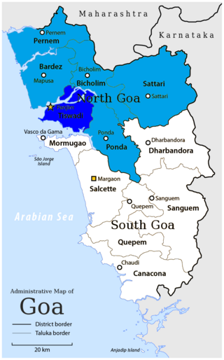
Tiswadi, formerly known as Ilhas de Goa, is a sub district in the district of North Goa, situated in the Indian coastal state of Goa. It is an estuarine island situated on the confluence of the Mandovi and Zuari rivers. It was one of the first territories to be annexed by Portugal in the sixteenth century. Both the state capital Panaji, and the erstwhile capital Old Goa lie within the subdistrict. It is the biggest and most populated of the six major islands between the Mandovi and Zuari rivers.
Cumbarjua, is an island and town within the Mandovi River in Goa. It is situated to the east of Goa's capital Panjim at a distance of 20 kilometres.

Cortalim is a village in Morumugão, Goa, India. Its native Goan population is entirely Catholic and their main occupations include fishing and agriculture. Located on the banks of the Zuari River, it was previously known as Kushasthale.
Amona is a census town in North Goa district in the state of Goa, India.
St Estevam is an estuarine islet in the Tiswadi taluka, Goa state, India. St Estevam is commonly referred as Jūvã (Isle) and has earned the monicker Šākêchô Jūvõ—the island of vegetables—famed for its long, seven-ridged, light green ladyfingers. Therefore, the people of Jūvã came to be nicknamed bhennddem. The island is named after St. Stephen. It is one of Goa's most prosperous villages, often quoted by ex-Chief Minister Pratapsingh Rane for having a high per capita income.

São Mathias also known as Malar is a village on Divar Island, Tiswadi or Ilhas, in the Indian state of Goa. The island is located 10 km upriver from Panjim.

The Zuari Bridge is a bridge between North Goa and South Goa, India. It carries the NH 66 over the tidal part of the Zuari River, between the villages of Agaçaim and Cortalim. It is a few metres downstream of the Konkan Railway Bridge.
Vanxim or Capão is an island of Goa situated in the Ilhas region. One can reach here by taking a ferry from Divar. The colonial name for Vanxim was Capão. One may see a lot of houses with few villagers many of whom are fisher-folk in the area. Silveiras, Furtados, Vas, Olivera are surnames of people. Mahendra Gaunekar sold the parts of the island to Ozone corporate. Luxury hotel and Golf Course is sort to be forced upon this island but faced resistance from alert islanders and others.
Santa Cruz Assembly constituency is one of the original Goa Legislative Assembly constituency seats in the Tiswadi Taluka of North Goa District in the State of Goa. The other constituencies in Tiswadi are Panaji, Taleigao, St. Andre and Cumbarjua.
Naroa is a village located on the eastern tip of the island of Divar, in the Indian state of Goa. It has a population of barely a thousand people, with about 80 houses.

The Atal Setu is a cable-stayed bridge in Goa that runs between Panaji and Porvorim. It carries National Highway 66 over the tidal part of the Mandovi River. It is 5.1 kilometres (3.2 mi) long, making it the third longest cable-stayed bridge in India. Two wheelers, three wheelers and bullock carts are prohibited from using the Atal Setu due to its height of 30 metres (98 ft). It officially opened on 5 February 2019.

The Mandovi bridge is a set of two bridges. It carries four lanes over the Mandovi river. It was Russian in design and the first to be used in this country. The first Mandovi bridge was built in 1971 and the second one in 1998.
The Cumbarjua Canal is a distributary channel formed by the merger of the Mandovi and Zuari rivers in Goa, India. It's flow has led to the formation of river deltas, most prominent of them are - Ilhas de Goa, Cumbarjua and St Estevam.


