Goat Canyon (Carrizo Gorge)

Last updated

Goat Canyon
Goat Canyon.jpg
The canyon with Goat Canyon Trestle
Floor elevation1,690 ft (520 m) [1]
Area Jacumba Mountains [2]
Geography
Location Carrizo Gorge [2]
Coordinates 32°43′57″N116°11′23″W / 32.73250°N 116.18972°W / 32.73250; -116.18972 [1]

Goat Canyon is a valley in San Diego County, California, United States, located within the Carrizo Gorge in the Jacumba Mountains. [2] [1] The rock forming the canyon is crystalline basement. [3] One feature of the canyon is a dry waterfall. [4] The canyon is bridged by a wooden railroad trestle, the Goat Canyon Trestle, [2] [5] which is the world's largest curved all-wood trestle. [6] The canyon is accessible by trail by traveling west from Mortero Palms. [7]

Contents

Flora and fauna

Goat Canyon is named after desert bighorn sheep that live within and around the canyon. [8] During a desert bloom, which occurred in 2017, monkey flowers were observed flowering in the canyon. [9] The endangered species least Bell's vireo migrates through the area around the canyon. [10]

Human history

Panoramic photograph of Goat Canyon Trestle and Tunnel number 15 Goat Canyon Trestle 7 of 8.jpg
Panoramic photograph of Goat Canyon Trestle and Tunnel number 15

Prior to Spanish governance, there was Native American activity in the area around Goat Canyon; [11] the impact of this activity includes petroglyphs and pictograms in Carrizo Gorge. [12] The last Native Americans to live in the area were the Kumeyaay. [13] Later cattle ranchers utilized the area. [14] Beginning in 1912, construction began on the San Diego and Arizona Eastern Railway in the area. [13] The Carrizo Gorge portion of the line, including Goat Canyon, was the final portion to be completed. [15] A railroad tunnel of The San Diego and Arizona Railway, Tunnel number 15, was built into the side of the canyon but it collapsed in 1932. [16] The collapse was caused by an earthquake, which dramatically changed the inclination of Tunnel number 15. [17] After Tunnel number 15 collapsed, it was decided that it would be bypassed using a wooden trestle. [18] During the construction of the trestle, segments were lowered into the canyon from the partially completed trestle. [19] Construction workers took breaks in a portion of the collapsed tunnel that they called the "mud shed". [20] The trestle was completed in 1933. [21]

In 1976 Hurricane Kathleen's effects impacted the region around the canyon, destroying tracks and other trestles in Carrizo Gorge; [22] the trestle over Goat Canyon was also damaged, with some of its footings destroyed during the hurricane. [23] By 1981, repairs from the hurricane damage were completed. [24] Heavy rains returned to the area in 1982 and 1983; [25] this led to rail service being discontinued over Goat Canyon and through Carrizo Gorge. [26] After repairs were again completed, trains once again ran over Goat Canyon in 2004. [5] [27] [28] [29] In 2008 the trains once again stopped running over Goat Canyon. [27] [28] [30]

In 1999, Huell Howser traveled to the canyon to visit the trestle over it. [31] In 2017, the canyon was depicted in a "Mysteries of the Abandoned" episode on the Science Channel. [32]

Other uses

There is another Goat Canyon in San Diego County, which is located north of the Mexico–United States barrier and south of the Tijuana River. [33]

Related Research Articles

<span class="mw-page-title-main">Anza-Borrego Desert State Park</span> State park in California, United States

Anza-Borrego Desert State Park is a California State Park located within the Colorado Desert of southern California, United States. The park takes its name from 18th century Spanish explorer Juan Bautista de Anza and borrego, a Spanish word for sheep. With 585,930 acres (237,120 ha) that includes one-fifth of San Diego County, it is the largest state park in California and the third largest state park nationally.

<span class="mw-page-title-main">San Diego and Arizona Railway</span> U.S. railroad founded by John D. Spreckels

The San Diego and Arizona Railway was a 148-mile (238 km) short line U.S. railroad founded by entrepreneur John D. Spreckels, and dubbed "The Impossible Railroad" by engineers of its day due to the immense logistical challenges involved. It linked San Diego, its western terminus, with El Centro, its eastern terminus, where passengers could connect with Southern Pacific's transcontinental lines, eliminating the need to first travel north via Los Angeles or Riverside.

<span class="mw-page-title-main">San Diego and Arizona Eastern Railway</span> Short-line American railroad founded in 1906

The San Diego and Arizona Eastern Railway Company is a short-line American railroad founded in 1906 as the San Diego and Arizona Railway (SD&A) by sugar magnate, developer, and entrepreneur John D. Spreckels. Dubbed "The Impossible Railroad" by many engineers of its day due to the immense logistical challenges involved, the line was established in part to provide San Diego with a direct rail link to the east by connecting with the Southern Pacific Railroad lines in El Centro, California.

<span class="mw-page-title-main">San Diego and Imperial Valley Railroad</span> Class III railroad in San Diego County, California, US

The San Diego and Imperial Valley Railroad (SD&IV) is a class III railroad operating freight rail service in the San Diego area, providing service to customers in the region and moving railcars between the end of the BNSF Railway in Downtown San Diego and the Mexico–United States border in San Ysidro. The railroad has exclusive trackage rights to operate over tracks of the San Diego and Arizona Eastern Railway, a subsidiary of the Metropolitan Transit System, the regional public transit service provider. Tracks are shared with the San Diego Trolley, another subsidiary of the Metropolitan Transit System, and freight trains are only operated at night when passenger service is not in operation. The San Diego & Imperial Valley Railroad was established in October 1984 and is owned and operated by Genesee & Wyoming, a holding company that operates more than 100 shortline railroads like the SD&IV.

<span class="mw-page-title-main">Carrizo Gorge Railway</span> American railroad operator

Carrizo Gorge Railway, Inc. was a railroad operator on the San Diego and Arizona Eastern Railway (SD&AE) from Tijuana, Mexico, to Plaster City, California.

<span class="mw-page-title-main">Fish Creek Mountains Wilderness</span> Protected wilderness area in California, United States

The Fish Creek Mountains Wilderness is located about 25 miles west of Brawley, California, and southeast of the Vallecito Mountains in the United States. The wilderness is located in the Fish Creek Mountains region in the northern part of the Carrizo Impact Area, which is closed to the public.

The Carrizo Impact Area was used by the United States Navy as an air-to-ground bombing range during World War II and the Korean War. It is in the Anza-Borrego Desert in south central California and covers about 45 square miles (120 km2). The majority of the range is in Anza-Borrego Desert State Park and about a third is owned by the United States Bureau of Land Management, including the Fish Creek Mountains Wilderness. The Navy currently only owns about 2 percent of the land and about 5 percent is privately owned. There are no structures or habitations within a 20-mile (32 km) radius of the site.

<span class="mw-page-title-main">Mud Caves</span> Cave feature in California, US

The Mud Caves are a popular feature in Anza Borrego Desert State Park in San Diego County, California. The caves, located in the Carrizo Badlands, along the Arroyo Tapiado, were created by water flowing through a thick deposit of silt and are an example of pseudokarst topography. There are at least 22 caves, some up to 1,000 feet (300 m) in length and 80 feet (24 m) in height. Many of the caves are easily accessed.

<span class="mw-page-title-main">Coyote Mountains</span> Mountain range in California, United States

The Coyote Mountains are a small mountain range in San Diego and Imperial Counties in southern California. The Coyotes form a narrow ESE trending 2 mi (3.2 km) wide range with a length of about 12 mi (19 km). The southeast end turns and forms a 2 mi (3.2 km) north trending "hook". The highest point is Carrizo Mountain on the northeast end with an elevation of 2,408 feet (734 m). Mine Peak at the northwest end of the range has an elevation of 1,850 ft (560 m). Coyote Wash along I-8 along the southeast margin of the range is 100 to 300 feet in elevation. Plaster City lies in the Yuha Desert about 5.5 mi (8.9 km) east of the east end of the range.

<span class="mw-page-title-main">Sawtooth Mountains Wilderness</span> Protected wilderness area in California, United States

The Sawtooth Mountains Wilderness is a federal wilderness area of 32,136 acres (130.0 km2) located in the Sawtooth Mountains in eastern San Diego County, California. It is located in the Colorado Desert, 35 miles (56 km) south of Borrego Springs, near Anza Borrego Desert State Park.

<span class="mw-page-title-main">Santa Rosa Wilderness</span> Protected wilderness area in California, United States

The Santa Rosa Wilderness is a 72,259-acre (292.42 km2) wilderness area in Southern California, in the Santa Rosa Mountains of Riverside and San Diego counties, California. It is in the Colorado Desert section of the Sonoran Desert, above the Coachella Valley and Lower Colorado River Valley regions in a Peninsular Range, between La Quinta to the north and Anza Borrego Desert State Park to the south. The United States Congress established the wilderness in 1984 with the passage of the California Wilderness Act, managed by both the US Forest Service and the Bureau of Land Management. In 2009, the Omnibus Public Land Management Act was signed into law which added more than 2,000 acres (8.1 km2). Most of the Santa Rosa Wilderness is within the Santa Rosa and San Jacinto Mountains National Monument.

<span class="mw-page-title-main">Butterfield Overland Mail in California</span> Historic route by state

The Butterfield Overland Mail in California was created by the United States Congress on March 3, 1857, and operated until June 30, 1861. Subsequently, other stage lines operated along the Butterfield Overland Mail in route in Alta California until the Southern Pacific Railroad arrived in Yuma, Arizona in 1877.

Earthquake Valley is a desert valley east of Julian, California, which contains parts of the Anza-Borrego Desert State Park. It is the location of the Shelter Valley Ranchos subdivision, which is also known as the unincorporated community of Shelter Valley. The official USGS place name for the geologic feature in which Shelter Valley is situated is "Earthquake Valley", and the 1959 USGS Topographic map makes no reference to Shelter Valley. The name of the unincorporated community Shelter Valley is typically used both locally and by the media to refer generally to the geological feature of Earthquake Valley, and it is common for both names to be referenced in publications after the 1962 establishment of the subdivision. Author, poet, artist and primitivist Marshal South lived in and wrote about the general area, in a series of articles for Desert Magazine between 1941 and 1948. A number of notable trails pass through the valley, including the Pacific Crest Trail, the California Riding and Hiking Trail, and the Southern Emigrant Trail.

Sunbelt Publications is an American publication company that was incorporated in 1988. The company publishes and distributes multi-language pictorials, natural science and outdoor guidebooks, and regional references. The company is located in El Cajon, California.

<span class="mw-page-title-main">Palm Spring, San Diego County, California</span> Historical Landmark in Anza-Borrego Desert State Park, United States

Palm Spring is a spring in Mesquite Oasis, a desert oasis amidst a mesquite thicket and a few palms, close to Carrizo Creek, within the Anza-Borrego Desert State Park in San Diego County, California.

Carrizo Creek Station, a former stage station of the San Antonio-San Diego Mail Line and Butterfield Overland Mail, located in Imperial County, California just east of the San Diego County line. It lies within the boundaries of the Anza-Borrego Desert State Park just west of the Carrizo Impact Area. Its site is located along the bank of Carrizo Creek.

San Felipe Creek is a stream in Imperial and San Diego Counties of California. It arises in the Volcan Mountains of San Diego County 33°11′57″N116°37′35″W, and runs eastward, gathering the waters of most of the eastern slope of the mountains and desert of the county in the San Sebastian Marsh before it empties into the Salton Sea. It is probably the last remaining perennial natural desert stream in the Colorado Desert region. In 1974, the San Felipe Creek Area was designated as a National Natural Landmark by the National Park Service.

<span class="mw-page-title-main">Clinton Gilbert Abbott</span> American ornithologist and naturalist

Clinton Gilbert Abbott was an American ornithologist, naturalist, and Director of the San Diego Natural History Museum from 1922 to 1946. Abbott supervised the construction of the museum's current building in Balboa Park, expanded research field trips and expeditions, and participated in important conservation efforts in southern California and the Baja California region. He was instrumental in the preservation of the southern California desert area that became Anza-Borrego Desert State Park.

<span class="mw-page-title-main">Goat Canyon Trestle</span> Historic wooden railway bridge in southern California, United States

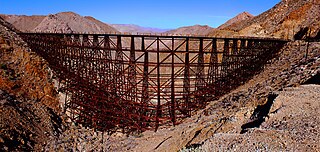
Goat Canyon Trestle is a wooden trestle in San Diego County, California. At a length of 597–750 feet (182–229 m), it is the world's largest all-wood trestle. Goat Canyon Trestle was built in 1933 as part of the San Diego and Arizona Eastern Railway, after one of the many tunnels through the Carrizo Gorge collapsed. The railway had been called the "impossible railroad" upon its 1919 completion. It ran through Baja California and eastern San Diego County before ending in Imperial Valley. The trestle was made of wood, rather than metal, due to temperature fluctuations in the Carrizo Gorge. By 2008, most rail traffic stopped using the trestle.

Canebrake Canyon is a valley at an elevation of 1145 feet in the deserts of Southern California. Canebrake Canyon is found southwest of Mesquite Oasis, northeast of the Tierra Blanca Mountains. An open wilderness of San Diego County, California, it is reached nearby from popular Anza-Borrego Desert State Park and is a remote hiking destination.

References

  1. 1 2 3 "Goat Canyon". Geographic Names Information System. United States Geological Survey. 19 January 1981. Archived from the original on 30 March 2018. Retrieved 28 March 2018.
  2. 1 2 3 4 Sheri McGregor (4 January 2007). Day and Overnight Hikes: Anza-Borrego Desert State Park. Menasha Ridge Press. p. 166. ISBN   978-0-89732-769-5.
  3. James R. Evans (1988). Landslides in Crystalline Basement Terrain: Annual Field Trip 1988. San Diego Association of Geologists.
  4. Baran, Robert (29 May 2010). "Goat Canyon Trestle Trek". San Diego Reader. Retrieved 28 March 2010.
  5. 1 2 Japenga, Ann (30 March 2004). "Rail renegades". Los Angeles Times. Retrieved 15 February 2018.
  6. Bell, Diane (19 April 2017). "Science Channel spotlights marvel in San Diego's back yard". San Diego Union Tribune. Retrieved 15 February 2018.
  7. Lowell Lindsay; Diana Lindsay (10 October 2017). Anza Borrego Desert Region: Your Complete Guide to the State Park and Adjacent Areas of the Western Colorado Desert. Wilderness Press. p. 437. ISBN   978-0-89997-780-5.
    Jerry Schad; Scott Turner (20 February 2017). Afoot and Afield: San Diego County: 282 Spectacular Outings Along the Coast, Foothills, Mountains, and Desert. Wilderness Press. pp. 1034–1035. ISBN   978-0-89997-802-4.
  8. The Canyoneers (19 July 2017). "Get close but not too close to Carrizo Gorge trestle". San Diego Reader. Retrieved 28 March 2018.
  9. Brandis, Jack (6 April 2017). "Weekend Driver: Flowergeddon". San Diego Union-Tribune. Retrieved 28 March 2018.
  10. "Eastern San Diego County Resource Management Plan and Record of Decision" (PDF). El Centro Field Office. Bureau of Land Management. October 2008. Archived from the original (PDF) on 30 January 2019. Retrieved 16 February 2018.
  11. Preliminary Wilderness Recommendations for the Eastern San Diego County Planning Unit: Department of the Interior Final Environmental Impact Statement. The Bureau. 1986. p. 61.
  12. American Antiquity. Society for American Archaeology. 1943. p. 160.
    Don Gennero (2009). "Desert Don's Native American Rock Art Gallery". University of San Diego. Retrieved 29 March 2018.
    Baran, Robert (3 April 2010). "Desert Treasure". San Diego Reader. Archived from the original on 30 March 2018. Retrieved 29 March 2018. Alt URL
    Dennis Slifer; Museum of New Mexico. Press (2000). The serpent and the sacred fire: fertility images in Southwest rock art. Museum of New Mexico Press. p. 77. ISBN   9780890133460.
    Fred Hirschmann; Scott Thybony (1994). Rock Art of the American Southwest. Graphic Arts Center Pub. p. 26. ISBN   978-1-55868-163-7.
  13. 1 2 The Canyoneers (8 April 2015). "How did this support life?". San Diego Reader. Retrieved 29 March 2018.
  14. Eastern San Diego County Resource Management Plan: Environmental Impact Statement. 2007.
    Thomson, Heather; Wade, Sue (2009). "Attachment I: San Diego County Ranching Interviews" (PDF). The Warner-Carrillo Ranch House. Save Our Heritage Organization. Retrieved 29 March 2018.
    Lawrence Hogue (May 2000). All the Wild and Lonely Places: Journeys In A Desert Landscape. Island Press. p. 99. ISBN   978-1-59726-336-8.
  15. Price, James N. (Spring 1988). "The Railroad Stations of San Diego County". The Journal of San Diego History. 34 (2). San Diego Historical Society. Retrieved 29 March 2018.
    O'Bannon, Patrick (Fall 1979). "Railroad Construction in the Early Twentieth Century: The San Diego and Arizona Railway". Southern California Quarterly. 61 (3). University of California Press: 255–290. doi:10.2307/41170830. JSTOR   41170830.
  16. The Canyoneers (19 July 2017). "Get close but not too close to Carrizo Gorge trestle". San Diego Reader. Retrieved 15 January 2018.
  17. Brennen, Christopher (10 February 2001). "Adventure Hikes and Canyooneering In The Southwest". Caltech. Retrieved 29 March 2018.
    surfponto (23 February 2009). "Goat Canyon Trestle Revisited". anzaborrego.net. Retrieved 29 March 2018.
    Phillip T. Farquharson; David M. Bloom; Carole L. Ziegler (2006). Geology and History of Southeastern San Diego County, California: San Diego Association of Geologists for 2005 and 2006. San Diego Association of Geologists. p. 78. ISBN   978-0-916251-78-9.
  18. Pacific Rail News. Interurbans Publications. 1995. p. 44.
  19. Reena Deutsch (2011). San Diego and Arizona Railway: The Impossible Railroad. Arcadia Publishing. p. 75. ISBN   978-0-7385-8148-4.
  20. Reena Deutsch (2011). San Diego and Arizona Railway: The Impossible Railroad. Arcadia Publishing. p. 76. ISBN   978-0-7385-8148-4.
  21. The Canyoneers (19 July 2017). "Get close but not too close to Carrizo Gorge trestle". San Diego Reader. Retrieved 29 March 2018.
    Jerry Schad; Scott Turner (20 February 2017). Afoot and Afield: San Diego County: 282 Spectacular Outings Along the Coast, Foothills, Mountains, and Desert. Wilderness Press. p. 1020. ISBN   978-0-89997-802-4.
  22. Beck, Darell (1 December 2011). "On Memory's Back Trail: The Impossible Railroad". Ramona Home Journal. Archived from the original on 18 February 2018. Retrieved 29 March 2018.
    Tony Huegel (21 December 2006). California Desert Byways: 68 of California's Best Backcountry Drives. Wilderness Press. p. 168. ISBN   978-0-89997-413-2.
  23. Reena Deutsch (2011). San Diego and Arizona Railway: The Impossible Railroad. Arcadia Publishing. p. 107. ISBN   978-0-7385-8148-4.
  24. Jerry Schad (1996). 101 Hikes in Southern California: Exploring Mountains, Seashore, and Desert. Wilderness Press. p. 206. ISBN   978-0-89997-193-3.
  25. Paul Remeika; Anne Aleda Sturz (1995). Paleontology and Geology of the Western Salton Trough Detachment, Anza-Borrego Desert State Park, California. San Diego Geological Soc. p. 11.
  26. Binational Rail: Connecting The Region (PDF) (Report). University of California, San Diego. 15 August 2015. Retrieved 29 March 2018.
    Reena Deutsch (2011). San Diego and Arizona Railway: The Impossible Railroad. Arcadia Publishing. p. 116. ISBN   978-0-7385-8148-4.
    Sanderson, Kirk (February 2004). "South County". San Diego Magazine. Retrieved 29 March 2018.
    SANDAG (June 2007). San Diego & Arizona Eastern Railway (SD&AE) (PDF) (Report). Retrieved 29 March 2018.
  27. 1 2 Hargrove, Dorian (10 September 2014). "Crazy Train". San Diego Reader. Retrieved 29 March 2018.
  28. 1 2 Hargrove, Dorian (1 September 2016). "Binational railroad continues up steep grade". San Diego Reader. Retrieved 29 March 2018.
  29. Lowell Lindsay; Diana Lindsay (10 October 2017). Anza Borrego Desert Region: Your Complete Guide to the State Park and Adjacent Areas of the Western Colorado Desert. Wilderness Press. p. 434. ISBN   978-0-89997-780-5.
  30. Dibble, Sandra (11 February 2013). "Rebuilding historic U.S.-Mexico rail link". San Diego Union-Tribune. Retrieved 29 March 2018.
  31. "Trestle- California's Gold (1006)". Huell Howser Archives. Chapman University. 8 January 1999. Retrieved 15 February 2018.
  32. Bell, Diane (24 April 2018). "Brad Paisley launches album from Midway carrier deck". San Diego Union-Tribune. Retrieved 29 March 2018.
  33. Abcarian, Robin (13 March 2018). "If Trump really wants to fix our border problems, he should visit the sewage pools, not his silly walls". Los Angeles Times. Retrieved 28 March 2018.
    "Contamination forces volunteer group out of Goat Canyon trash pickup". KFMB. San Diego. 14 October 2017. Retrieved 28 March 2018.
    Graham, Marty (2 March 2017). "Goat Canyon spills...black tea?". San Diego Reader. Retrieved 28 March 2018.