
Spruce View is a hamlet in central Alberta, Canada within Red Deer County. It is located on Highway 54, approximately 30 kilometres (19 mi) west of Innisfail. Spruce View is also recognized by Statistics Canada as a designated place.
Tworzymirki Górne is a village in the administrative district of Gmina Milicz, within Milicz County, Lower Silesian Voivodeship, in south-western Poland. Prior to 1945 it was in Germany.
Olszówka is a village in the administrative district of Gmina Twardogóra, within Oleśnica County, Lower Silesian Voivodeship, in south-western Poland. Prior to 1945 it was in Germany.

Borówki is a village in the administrative district of Gmina Sośno, within Sępólno County, Kuyavian-Pomeranian Voivodeship, in north-central Poland. It lies approximately 5 kilometres (3 mi) north-west of Sośno, 9 km (6 mi) south-east of Sępólno Krajeńskie, and 42 km (26 mi) north-west of Bydgoszcz.
Gródek-Kolonia is a settlement in the administrative district of Gmina Gródek, within Białystok County, Podlaskie Voivodeship, in north-eastern Poland, close to the border with Belarus.
Krzywa is a village in the administrative district of Gmina Jasionówka, within Mońki County, Podlaskie Voivodeship, in north-eastern Poland.

Isaqlı is a village in the Jabrayil Rayon of Azerbaijan.
Unuz is a village in the Astara Rayon of Azerbaijan.
Kręciszówka is a village in the administrative district of Gmina Opole Lubelskie, within Opole Lubelskie County, Lublin Voivodeship, in eastern Poland.
Mała Wieś przy Drodze is a village in the administrative district of Gmina Leoncin, within Nowy Dwór Mazowiecki County, Masovian Voivodeship, in east-central Poland.
Drochówka is a village in the administrative district of Gmina Naruszewo, within Płońsk County, Masovian Voivodeship, in east-central Poland.
Ostrówek is a village in the administrative district of Gmina Rząśnik, within Wyszków County, Masovian Voivodeship, in east-central Poland.
Koziegłowy is a village in the administrative district of Gmina Kleczew, within Konin County, Greater Poland Voivodeship, in west-central Poland.
Pieczyska is a village in the administrative district of Gmina Doruchów, within Ostrzeszów County, Greater Poland Voivodeship, in west-central Poland. It lies approximately 7 kilometres (4 mi) west of Doruchów, 3 km (2 mi) north of Ostrzeszów, and 132 km (82 mi) south-east of the regional capital Poznań.
Niepoczołowice-Folwark is a village in the administrative district of Gmina Linia, within Wejherowo County, Pomeranian Voivodeship, in northern Poland. It lies approximately 5 kilometres (3 mi) south-west of Linia, 31 km (19 mi) south-west of Wejherowo, and 49 km (30 mi) west of the regional capital Gdańsk.
Stare Dolno is a village in the administrative district of Gmina Markusy, within Elbląg County, Warmian-Masurian Voivodeship, in northern Poland. It lies approximately 6 kilometres (4 mi) south-east of Markusy, 11 km (7 mi) south of Elbląg, and 75 km (47 mi) west of the regional capital Olsztyn.
Gajewo is a village in the administrative district of Gmina Giżycko, within Giżycko County, Warmian-Masurian Voivodeship, in northern Poland.
Koidula is a village in Saaremaa Parish, Saare County in western Estonia.
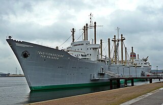
The Frieden is the former German motor vessel Dresden operated by the VEB Deutsche Seereederei Rostock. Since 1970 it has been used as a museum ship.
SVA Papendorp are a Dutch amateur football (soccer) club from Utrecht, founded in 1990. The club holds a Saturday team competing in the Derde Divisie, the fourth tier of professional football in the Netherlands.


