Komorowo is a village in the administrative district of Gmina Bartniczka, within Brodnica County, Kuyavian-Pomeranian Voivodeship, in north-central Poland.
Jeziorki is a village in the administrative district of Gmina Osiek, within Brodnica County, Kuyavian-Pomeranian Voivodeship, in north-central Poland.

Wyględów is a neighborhood in Mokotów district of Warsaw, Poland.

Tomaszewo is a village in the administrative district of Gmina Lipno, within Lipno County, Kuyavian-Pomeranian Voivodeship, in north-central Poland. It lies approximately 5 kilometres (3 mi) south-east of Lipno and 47 km (29 mi) south-east of Toruń.
Drużbice-Kolonia is a village in the administrative district of Gmina Drużbice, within Bełchatów County, Łódź Voivodeship, in central Poland.

Włosków is a village in the administrative district of Gmina Kutno, within Kutno County, Łódź Voivodeship, in central Poland. It lies approximately 10 kilometres (6 mi) south-west of Kutno and 49 km (30 mi) north of the regional capital Łódź.

Głupiejew is a settlement in the administrative district of Gmina Góra Świętej Małgorzaty, within Łęczyca County, Łódź Voivodeship, in central Poland. It lies approximately 13 kilometres (8 mi) east of Łęczyca and 35 km (22 mi) north of the regional capital Łódź.

Janów is a settlement in the administrative district of Gmina Góra Świętej Małgorzaty, within Łęczyca County, Łódź Voivodeship, in central Poland. It lies approximately 13 kilometres (8 mi) east of Łęczyca and 35 km (22 mi) north of the regional capital Łódź.
Galbierka is a village in the administrative district of Gmina Złoczew, within Sieradz County, Łódź Voivodeship, in central Poland.

Tkaczew is a village in the administrative district of Gmina Ozorków, within Zgierz County, Łódź Voivodeship, in central Poland. It lies approximately 8 kilometres (5 mi) north-west of Ozorków, 24 km (15 mi) north-west of Zgierz, and 31 km (19 mi) north-west of the regional capital Łódź.

Zagorzyce is a village in the administrative district of Gmina Miechów, within Miechów County, Lesser Poland Voivodeship, in southern Poland. It lies approximately 4 kilometres (2 mi) north-west of Miechów and 36 km (22 mi) north of the regional capital Kraków.

Cieciórki Szlacheckie is a village in the administrative district of Gmina Czerwonka, within Maków County, Masovian Voivodeship, in east-central Poland. It lies approximately 4 kilometres (2 mi) north of Czerwonka, 10 km (6 mi) north-east of Maków Mazowiecki, and 80 km (50 mi) north of Warsaw.
Królewiec is a village in the administrative district of Gmina Witkowo, within Gniezno County, Greater Poland Voivodeship, in west-central Poland.

Goplana is a village in the administrative district of Gmina Skulsk, within Konin County, Greater Poland Voivodeship, in west-central Poland. It lies approximately 4 kilometres (2 mi) south-east of Skulsk, 29 km (18 mi) north of Konin, and 100 km (62 mi) east of the regional capital Poznań.
Libartowo is a village in the administrative district of Gmina Kostrzyn, within Poznań County, Greater Poland Voivodeship, in west-central Poland.

Okrągłe is a village in the administrative district of Gmina Ujsoły, within Żywiec County, Silesian Voivodeship, in southern Poland, close to the border with Slovakia. It lies approximately 6 kilometres (4 mi) north-east of Ujsoły, 22 km (14 mi) south of Żywiec, and 85 km (53 mi) south of the regional capital Katowice.

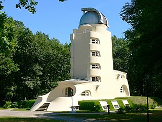
The Albert Einstein Science Park is located on the hill Telegrafenberg in Potsdam, Germany. The park was named after the physicist Albert Einstein. The best known buildings in the park are the Einstein Tower, an astrophysical observatory that was built to perform checks of Einstein's theory of General Relativity; and the Great Refractor of Potsdam, which today belong to the Astrophysical Institute Potsdam. These buildings, along with various astronomical, meteorological, and geophysical observatories were integrated into an English country garden.
Kaali-Liiva is a village in Saaremaa Parish, Saare County in western Estonia.

Jablanica (Višegrad) is a village in the municipality of Višegrad, Bosnia and Herzegovina.
Pat Rud Pey is a village in Shahidabad Rural District, Bandpey-ye Gharbi District, Babol County, Mazandaran Province, Iran. At the 2006 census, its population was 462, in 127 families.


