
San Pedro is a town on the southern part of the island of Ambergris Caye in the Belize District of the nation of Belize, in Central America. According to the 2015 mid-year estimates, the town has a population of about 16,444. It is the second-largest town in the Belize District and largest in the Belize Rural South constituency. The once sleepy fishing village was granted the status of a town in 1984.

Ambergris Caye, is the largest island of Belize, located northeast of the country's mainland, in the Caribbean Sea. It is about 40 kilometres (25 mi) long from north to south, and about 1.6 kilometres (1 mi) wide. Many parts of the island have been modified by human development since the arrival of coconut plantations in the 17th century, but it remains largely white coral sand with mangrove forest at its center. Its eastern coast runs parallel to the northernmost stretch of the Belize Barrier Reef, a UNESCO World Heritage Site.

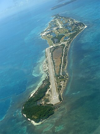
St. George's Caye is an island in the Caribbean Sea, eight miles east of Belize City. It is part of the Belize District of Belize, Central America. The village on the island is also known as St. George's Caye. As of 2000, St. George's Caye had a permanent population of about 20 people.

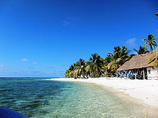
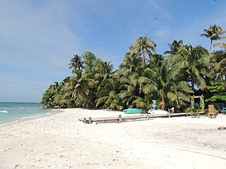
Caye Caulker is a small limestone coral island off the coast of Belize in the Caribbean Sea measuring about 5 miles (8.0 km) by less than 1 mile (1.6 km). The town on the island is known by the name Caye Caulker Village. The population of Caye Caulker is approximately 2,000 people today and still growing.
Caye Chapel is a small, private island in Belize, 16 miles (26 km) north-northeast of Belize City and 3 miles (4.8 km) south of Caye Caulker. It was once owned by Isaiah Emmanuel Morter, Belize's first African millionaire.
The Caribbean Coral Reef Ecosystems (CCRE) program began with a collaborative field project conceived by six National Museum of Natural History scientists during the early 1970s. The scientists interests included a range of disciplines central to reef ecology, including: invertebrate and vertebrate zoology, botany, carbonate geology, and paleobiology. The primary work site is the Carrie Bow Marine Field Station, a research station at Carrie Bow Caye on the Meso-American Barrier Reef in Belize. The program is an extended duration study of coral reefs, mangroves, sea grass meadows, and the sandy bottoms. It has been a functioning research program since the early 1970s when it was called the Investigations of Marine Shallow-Water Ecosystems (IMSWE).

Tourism in Belize has grown considerably recently, and it is now the second largest industry in the nation. Belizean Prime Minister Dean Barrow has stated his intention to use tourism to combat poverty throughout the country. The growth in tourism has positively affected the agricultural, commercial, and finance industries, as well as the construction industry. The results for Belize's tourism-driven economy have been significant, with the nation welcoming almost one million tourists in a calendar year for the first time in its history in 2012.

Tobacco Caye is a tiny island in Belize, about 10 miles east of Dangriga.
Laughing Bird Caye is an island off the coast of Placencia, Belize. On 21 December 1991, Laughing Bird Caye National Park was declared. It is spread over an area of 1.8 acres (0.73 ha). The island is named after a population of laughing gulls which previously bred there.
Blackadore Caye is a small island in Belize, west of Ambergris Caye, in the Caribbean Sea, not far from the Belize Barrier Reef.
Bacalar Chico National Park and Marine Reserve (BCNPMR) is a protected area and UNESCO World Heritage Site on the northern part of Ambergris Caye in Belize.
Sandbore Caye is a small island with an area of 10 acres (4.0 ha) 50 miles (80 km) off the coast of Belize. It is the northernmost as well as easternmost islet of Lighthouse Reef Atoll, and at the same time the easternmost landmass of the state of Belize. It has a lighthouse occupied by a keeper and his family. The census of 2012 numbered 4. 0.66 miles (1.06 km) to the southwest is the larger island, Northern Caye.
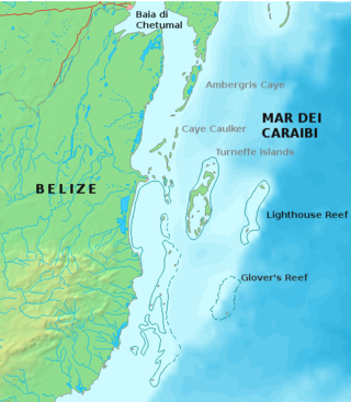
Glover's Reef is a partially submerged atoll located off the southern coast of Belize, approximately 45 kilometres from the mainland. It forms part of the outermost boundary of the Belize Barrier Reef, and is one of its three atolls, besides Turneffe Atoll and Lighthouse Reef.

Gladden Spit and Silk Cayes Marine Reserve (GSSCMR) is a protected marine reserve in the central part of Belize's Barrier Reef. It covers approximately 25,980 acres (10,510 ha) lying 36 kilometres (22 mi) off the coast of Placencia. Established in 2003, The reserve comes under the authority of the government's Fisheries Department, but is managed by the Southern Environmental Association, a community-based organisation.

Turneffe Atoll is located southeast of Ambergris Caye and Caye Caulker, off the coast of Belize in Central America, 20 miles from Belize City. It is one of three atolls of the Belize Barrier Reef, along with Glover's Reef and Lighthouse Reef. It is approximately 30 miles long and 10 miles wide, making it the largest coral atoll in Belize and in the Mesoamerican Barrier Reef System. The atoll was officially declared a marine reserve on November 22, 2012.

The extensive trade networks of the Ancient Maya contributed largely to the success of their civilization spanning three millennia. Maya royal control and the wide distribution of foreign and domestic commodities for both population sustenance and social affluence are hallmarks of the Maya visible throughout much of the iconography found in the archaeological record. In particular, moderately long-distance trade of foreign commodities from the Caribbean and Gulf Coasts provided the larger inland Maya cities with the resources they needed to sustain settled population levels in the several thousands. Though the ruling class essentially controlled the trade economy, a middle merchant class supervised import and export from cities and trade ports. Not much is known of the Maya merchant class; however, merchants of royal lineage are sometimes represented in the iconography. Notably, a canoe paddle often accompanies the royal merchant depictions, signifying their association with marine resources.

Lighthouse Reef is an atoll in the Caribbean Sea, the easternmost part of the Belize Barrier Reef and one of its three atolls, the other two being Turneffe Atoll and Glover's Reef. Lighthouse Reef is located about 80 kilometres (50 mi) southeast of Belize City. The atoll is of oblong shape, approximately 35 kilometres (22 mi) long from north to south, and about 8 kilometres (5.0 mi) wide. It forms a shallow sandy lagoon with an area of 120 square kilometres (46 sq mi) and a depth between 2 to 6 metres deep.
Ranguana Caye is a two-acre private island located roughly 20 miles west of Placencia, Belize. Those exploring the caye are required to set up transportation through private boat charters. The island includes a dock and moorings for visiting boats, located just off the Belize Barrier Reef. A day tour to the island is through Belize Ocean Club, a resort located in Maya Beach Village near Placencia and managed by Muy'Ono Properties. Snorkeling the Belize Barrier Reef and reef fishing are also some activities on the island.
Moho Caye, known locally as Wild Orchid Caye, is an 8.38 acre island located in the Caribbean Sea, off the coast of Belize. The island is located 12 miles east from Placencia, 9 miles from the Belize Barrier Reef, and has around 2,980 feet of beach.

The Principality of Islandia is an incipient micronation that claims Coffee Caye in the Caribbean Sea off the coast of Belize as its territory. Coffee Caye is a currently uninhabited island of 1.2 acres (0.5 ha) separated by a short boat trip from Belize City. Founded in 2018 by Gareth Johnson and Marshall Mayer, the project is the first attempt to create a micronation to be crowdfunded. At present the island, which is covered in mangroves and surrounded by coral reefs, can be rented for camping excursions.

