
Kalibangān is a town located at 29.47°N 74.13°E on the left or southern banks of the Ghaggar in Tehsil Pilibangān, between Suratgarh and Hanumangarh in Hanumangarh District, Rajasthan, India 205 km. from Bikaner. It is also identified as being established in the triangle of land at the confluence of Drishadvati and Sarasvati Rivers. The prehistoric and pre-Mauryan character of Indus Valley Civilization was first identified by Luigi Tessitori at this site. Kalibangan's excavation report was published in its entirety in 2003 by the Archaeological Survey of India, 34 years after the completion of excavations. The report concluded that Kalibangan was a major provincial capital of the Indus Valley Civilization. Kalibangan is distinguished by its unique fire altars and "world's earliest attested ploughed field"..It is around 2900 BC that the region of Kalibangan developed into what can be considered a planned city.

The Western Satraps, Western Kshatrapas, or Kshaharatas were Indo-Scythian (Saka) rulers of the western and central part of India. The Western Satraps were contemporaneous with the Kushans who ruled the northern part of the Indian subcontinent and were possibly their overlords, and the Satavahana (Andhra) who ruled in Central India. The power of the Saka rulers started to decline in the 2nd century CE after the Saka rulers were defeated by the Emperor Gautamiputra Satakarni of the Satavahana dynasty. Later the Saka kingdom was completely destroyed by Chandragupta II of the Gupta Empire in the 4th century CE.

Shikaripura Ranganatha Rao, commonly known as Dr. S. R. Rao, was an Indian archaeologist who led teams credited with discoveries of a number of Harappan sites including the port city Lothal and Bet Dwarka in Gujarat.

Rangpur is an ancient archaeological site near Vanala on Saurashtra peninsula in Gujarat, western India. Lying on the tip between the Gulf of Khambhat and Gulf of Kutch, it belongs to the period of the Indus Valley Civilization, and lies to the northwest of the larger site of Lothal. It is the type site for the Rangpur culture, a regional form of the late phase of the Indus Valley Civilization that existed in Gujarat during the 2nd millennium BCE.

Rupnagar district is one of twenty-two districts in the state of Punjab, India. The town of Rupnagar is said to have been founded by a Raja called Rokeshar, who ruled during the 11th century and named it after his son Rup Sen. It is also the site of an ancient town of the Indus Valley Civilization. The major cities in Ropar District are Morinda, Nangal and Anandpur Sahib. Morinda is also known as Baghwāla "[The City] of Gardens." Morinda is located on the Chandigarh-Ludhiana Highway. The Bhakra Dam in Nangal lies on the boundary with the neighboring state of Himachal Pradesh. Dadhi is one of the most important villages of the district, particularly because of Gurudwara Sri Hargobindsar Sahib.

Pottery in the Indian subcontinent has an ancient history and is one of the most tangible and iconic elements of Indian art. Evidence of pottery has been found in the early settlements of Lahuradewa and later the Indus Valley Civilization. Today, it is a cultural art that is still practiced extensively in Indian subcontinent. Until recent times all Indian pottery has been earthenware, including terracotta.
Ahichchhatra, near the modern Ramnagar village in Aonla tehsil, Bareilly district in Uttar Pradesh, India, was the ancient capital of Northern Panchala, a northern Indian kingdom mentioned in the Mahabharata.

Bhirrana, also Bhirdana and Birhana, is an archaeological site, located in a small village in Fatehabad District, in the Indian state of Haryana. Its history stretches back to pre-Harappan times, as revealed by archaeological discoveries, dating to the 8th-7th millennium BCE. The site is one of the many sites seen along the channels of the seasonal Ghaggar river, thought by some to be the mythical RigVedic Saraswati river.
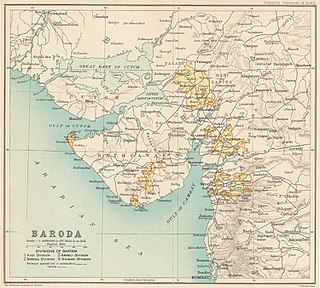
Baroda State was a state in present-day Gujarat, ruled by the Gaekwad dynasty of the Maratha Confederacy from its formation in 1721 until its accession to the newly-formed Dominion of India in 1949. With the city of Baroda (Vadodara) as its capital, during the British Raj its relations with the British were managed by the Baroda Residency. The revenue of the state in 1901 was Rs. 13,661,000. Baroda formally acceded to the Union of India, on 1 May 1949, prior to which an interim government was formed in the state.
Shikarpur is a village in Bhachau Taluka of Kutch district of Gujarat, India. Nearby excavations have revealed a site belonging to the Indus Valley Civilisation, also known as the Harappan civilisation.
Loteshwar is a village and an archaeological site belonging to Indus Valley Civilisation located at Patan district, Gujarat, India. This site is locally also known as Khari-no-timbo and located on a high sand dune on left bank of Khari river, a tributary of Rupen river.

Kunal is a pre-Harappan settlement located in Fatehabad district, Haryana, India. This Indus Valley Civilisation site was a village, in comparison to towns like Kalibangan and cities like Rakhigarhi of IVC. This site is located on Sarasvati plain.
Oriyo Timbo is an archeological site belonging to Indus Valley Civilisation located in Bhavnagar District, Gujarat State, India. The site is measures 4 hectares, located at a distance of 70 km from Rojdi, another Indus Valley site.
Baror is an archeological site in Sri Ganganagar district of Rajasthan, India. It belongs with ancient Indus Valley Civilization. Pre Harappan and Harappan pottery has been found after excavation.

The State Museum, Lucknow is a prominent museum located in the capital city of Uttar Pradesh, India. The museum is currently located in the Nawab Wajid Ali Shah Zoological Gardens, Banarasi Bagh, Lucknow. The museum was established in 1863 from the collection of Colonel Abbot, and was given the status of ‘Provincial Museum’ before being renamed the ‘State Museum’ in 1950.

The Akota Bronzes represent a rare and important set of 68 Jain images, dating to between the 6th and 12th centuries CE, which were found in the vicinity of Akota near Baroda in the Indian state of Gujarat. It includes rare Gupta period bronzes that have been widely used for comparison of Gupta period art.

The Rajgadhi Timbo is a mound and historical site of medieval Jain temple located in Umta village in Visnagar Taluka, Mehsana district, Gujarat, India. The site is State Protected Monument under Gujarat State Archeology Department (GSAD).

Srughna, also spelt Shrughna in Sanskrit, or Sughna, Sughana or Sugh in the spoken form, was an ancient city or kingdom of India frequently referred to in early and medieval texts. It was visited by Chinese traveller, Xuanzang in the 7th century and was reported to be in ruins even then although the foundations still remained. Xuanzang described the kingdom as extending from the mountains to the north, to the Ganges river to the East, and with the Jumna river flowing through it. He described the capital city on the west bank of the Jumna as possessing a large Buddhist vihara and a grand stupa dating to the time of the Mauryan emperor, Ashoka. Srughna is identified with the Sugh Ancient Mound located in the village of Amadalpur Dayalgarh, in the Yamunanagar district of Haryana state of India. To this day, the ancient Chaneti Buddhist Stupa, probably dating to the Mauryan period, stands in the area, about 3 kilometres (1.9 mi) northwest of Sugh.

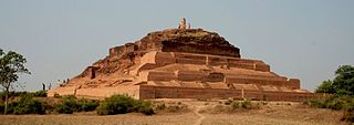
Devnimori, or Devni Mori, is a Buddhist archaeological site in northern Gujarat, about 2 kilometres (1.2 mi) from the city of Shamlaji, in the Aravalli District of northern Gujarat, India. The site is variously dated to the 3rd century or 4th century CE, or circa 400 CE. Its location was associated with trade routes and caravans in the area of Gujarat. Site excavations have yielded Buddhist artifacts dated prior to 8th-century in the lowest layer, mixed Buddhist and Hindu artwork from the Gurjara-Pratihara period in the middle, topped by Muslim glazed ware attributed to the 14th century. The site was excavated between 1960 and 1963. The site became flooded by a water reservoir, a project started in 1959 and completed over 1971-1972 over the nearby Meshwo River.
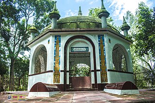
Patharghata is an ancient city and one of the most important archeological sites in Bangladesh located in Joypurhat district. It is located at Patharghata in Panchbibi upazila of the district. The Patharghata site is the site of several archeological sites. It is situated on the bank of the river Tulsiganga, 1.5 km east of the upazila headquarters. Traces of the ruins of this ancient city are found on both banks of the Tulsiganga River.

