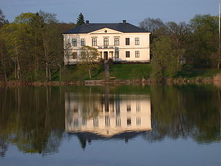
Charlottenborg Herrgård is a manor house in Motala, on the shores of Motala Stream, Östergötland, Sweden. The house was built in the mid 17th century by Ludvig Wierich Lewenhaupt and named in honour of his wife, Charlotte von Hohenlohe-Neuenstein. Charlottenborg has been home to both Adam Ludwig Lewenhaupt and Daniel Fraser.

Ramnagar is a town in Barabanki district in the state of Uttar Pradesh, India. It is a town, tehsil and a nagar panchayat in Barabanki District in the Indian state of Uttar Pradesh.

Hiragishi Station is a railway station on the Nemuro Main Line of JR Hokkaido located in Akabira, Hokkaidō, Japan.
Teodorówka is a village in the administrative district of Gmina Biłgoraj, within Biłgoraj County, Lublin Voivodeship, in eastern Poland.

Kürdlər is a village in the Fizuli Rayon of Azerbaijan.
Qaragöl is a village in the Zangilan Rayon of Azerbaijan.
Bazar is a village in the Zaqatala Rayon of Azerbaijan. The village forms part of the municipality of Çobankol.

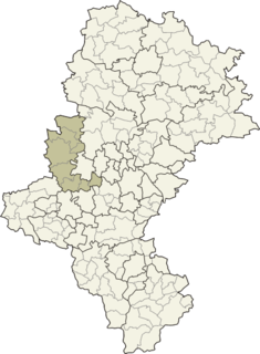
Stara Wieś is a village in the administrative district of Gmina Książ Wielki, within Miechów County, Lesser Poland Voivodeship, in southern Poland. It lies approximately 6 kilometres (4 mi) north-east of Książ Wielki, 19 km (12 mi) north-east of Miechów, and 51 km (32 mi) north of the regional capital Kraków.
Justynówka is a village in the administrative district of Gmina Tomaszów Lubelski, within Tomaszów Lubelski County, Lublin Voivodeship, in eastern Poland. It lies approximately 7 kilometres (4 mi) north-east of Tomaszów Lubelski and 107 km (66 mi) south-east of the regional capital Lublin.
Ostrów is a village in the administrative district of Gmina Ulhówek, within Tomaszów Lubelski County, Lublin Voivodeship, in eastern Poland, close to the border with Ukraine. It lies approximately 4 kilometres (2 mi) north of Ulhówek, 27 km (17 mi) east of Tomaszów Lubelski, and 121 km (75 mi) south-east of the regional capital Lublin.
Leszczków is a village in the administrative district of Gmina Lipnik, within Opatów County, Świętokrzyskie Voivodeship, in south-central Poland. It lies approximately 2 kilometres (1 mi) north of Lipnik, 9 km (6 mi) south-east of Opatów, and 64 km (40 mi) east of the regional capital Kielce.
Ryczki is a settlement in the administrative district of Gmina Ulanów, within Nisko County, Subcarpathian Voivodeship, in south-eastern Poland. It lies approximately 7 kilometres (4 mi) north-east of Ulanów, 14 km (9 mi) east of Nisko, and 61 km (38 mi) north of the regional capital Rzeszów.
Kozubów is a village in the administrative district of Gmina Pińczów, within Pińczów County, Świętokrzyskie Voivodeship, in south-central Poland. It lies approximately 12 kilometres (7 mi) south of Pińczów and 51 km (32 mi) south of the regional capital Kielce.
Wnorów is a village in the administrative district of Gmina Łoniów, within Sandomierz County, Świętokrzyskie Voivodeship, in south-central Poland. It lies approximately 3 kilometres (2 mi) west of Łoniów, 23 km (14 mi) south-west of Sandomierz, and 71 km (44 mi) south-east of the regional capital Kielce.
Lgota Murowana is a village in the administrative district of Gmina Kroczyce, within Zawiercie County, Silesian Voivodeship, in southern Poland. It lies approximately 3 kilometres (2 mi) south of Kroczyce, 12 km (7 mi) northeast of Zawiercie, and 52 km (32 mi) north-east of the regional capital Katowice.
Wyskok is a village in the administrative district of Gmina Srokowo, within Kętrzyn County, Warmian-Masurian Voivodeship, in northern Poland, close to the border with the Kaliningrad Oblast of Russia.
Kumki is a village in the administrative district of Gmina Drawsko Pomorskie, within Drawsko County, West Pomeranian Voivodeship, in north-western Poland. It lies approximately 5 kilometres (3 mi) west of Drawsko Pomorskie and 78 km (48 mi) east of the regional capital Szczecin.

Panamenik is a former Karok settlement in Humboldt County, California. The elevation of Panamenik is 413 feet.
Boukram is a town and commune in Bouïra Province, Algeria. According to the 1998 census it has a population of 6,275.
Sepa is a village in Saaremaa Parish, Saare County in western Estonia.