
The Hoh River is a river of the Pacific Northwest, located on the Olympic Peninsula in the U.S. state of Washington. About 56 miles (90 km) long, the Hoh River originates at the Hoh Glacier on Mount Olympus and flows west through the Olympic Mountains of Olympic National Park and Olympic National Forest, then through the foothills in a broad valley, emptying into the Pacific Ocean at the Hoh Indian Reservation. The final portion of the Hoh River's course marks the boundary between the coastal segment of Olympic National Park and Olympic National Forest, the Hoh Indian Reservation.

Curecanti National Recreation Area(Pronounced or .) is a National Park Service unit located on the Gunnison River in western Colorado. Established in 1965, Curecanti National Recreation Area is responsible for developing and managing recreational facilities on three reservoirs, Blue Mesa Reservoir, Morrow Point Reservoir and Crystal Reservoir, constructed on the upper Gunnison River in the 1960s by the U.S. Bureau of Reclamation to better utilize the vital waters of the Colorado River and its major tributaries. A popular destination for boating and fishing, Curecanti offers visitors two marinas, traditional and group campgrounds, hiking trails, boat launches, and boat-in campsites. The state's premiere lake trout and Kokanee salmon fisheries, Curecanti is a popular destination for boating and fishing, and is also a popular area for ice-fishing in the winter months.

Manchester State Park is a state park of California, United States. It includes 18,000 feet (5,500 m) of protected beachfront on the Pacific Ocean in Northern California on State Route 1, 7 miles (11 km) north of Point Arena. The park features sand dunes, flat grasslands and five miles of gentle, sandy beachfront. The park is noted for steelhead and salmon fishing in the park's two streams, Brush Creek and Alder Creek, as well as the driftwood that collects in the catch basin created by the gently curved coastline. The 5,272-acre (2,134 ha) site was established as a California state park in 1955 and takes its name from Manchester, California, seven miles north of Point Arena.

The Salmon River is a 33.5-mile (53.9 km) river in the Cascade Range in the U.S. state of Oregon that drains part of southwestern Mount Hood. The entire length of the river is a protected National Wild and Scenic River. Several portions are in protected wilderness. It is affluent to the Sandy River, a tributary of the Columbia River.

Sizerville State Park is a 386-acre (156 ha) Pennsylvania state park in Portage Township, Cameron County and Portage Township, Potter County, Pennsylvania in the United States. The park is nearly surrounded by Elk State Forest making it part of one of the largest blocks of state-owned land in Pennsylvania. Sizerville State Park is on Pennsylvania Route 155, six miles (10 km) north of the borough of Emporium.

The Lochsa River is in the northwestern United States, in the mountains of north central Idaho. It is one of two primary tributaries of the Middle Fork of the Clearwater River in the Clearwater National Forest. Lochsa is a Nez Perce word meaning rough water. The Salish name is Ep Smɫí, "It Has Salmon."
The Pine Ridge Trail is the most popular hiking trail in the Ventana Wilderness of the Los Padres National Forest, California. The 19.5 miles (31.4 km) trail traverses the Ventana Wilderness from the Big Sur Station near sea level to China Camp on Tassajara Road at 5,000 feet (1,500 m). Built in 1916 by the Post family of Big Sur, the Pine Ridge Trail offers hikers and equestrians an array of backcountry camps to enjoy.

Sykes Camp is located 10 miles (16 km) from the Pfeiffer Big Sur State Park trailhead along the Pine Ridge Trail. There were seven campsites along both sides of the Big Sur River, both upstream and downstream from where the trail intersects the river. There was a pit toilet downstream of this intersection.

The Middle Fork of the Salmon River is a 104-mile-long (167 km) river in central Idaho in the northwestern United States. It is a tributary to the Salmon River, and lies in the center of the 2.5-million-acre Frank Church-River of No Return Wilderness Area.

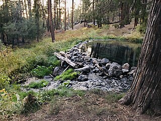
Olympic Hot Springs is located in Olympic National Park, Washington, United States. The springs contain 21 seeps near Boulder Creek, a tributary of the Elwha River. The temperature varies from lukewarm to 138 °F (59 °C).

The Ochoco Mountains are a mountain range in central Oregon in the United States, located at the western end of the Blue Mountains. They were formed when Permian, Triassic, and Jurassic rocks were slowly uplifted by volcanic eruptions to form the Clarno Formation. Today, the highest point in the range is Lookout Mountain. The dominant vegetation on the west side of the range is old-growth ponderosa pine; on the east side, western juniper is common. The western area of the mountains is administered by the Ochoco National Forest, while the southeastern section is part of the Malheur National Forest. The Ochoco Mountains are used for hiking, camping, bird watching, rockhounding, and hunting, as well as cross-country skiing in the winter.

Mono Hot Springs is a summer resort and campground at a group of hot springs in Fresno County, central California. It is located within the Sierra National Forest, 70 miles (110 km) northeast of Fresno via California State Route 168.
The Silver Knapsack Trail is a 36.2-mile (58.3 km) trail located in the Sierra Nevada Mountains, near Johnsondale, Springville, and Three Rivers, California. It is located in Sequoia National Forest and the southernmost part of Sequoia National Park. Much of the trail lies within the Golden Trout Wilderness.

The Little North Santiam River is a 27-mile (43 km) tributary of the North Santiam River in western Oregon in the United States. It drains 113 square miles (290 km2) of the Cascade Range on the eastern side of the Willamette Valley east of Salem.

Frustration Falls, is a three drop waterfall located on the Salmon River at the south skirt of the Mount Hood National Forest, in Clackamas County, in the U.S. state of Oregon. It is located in a privileged area where the river creates several waterfalls: Final Falls, Vanishing Falls, Little Niagara Falls, and Copper Creek Falls are within a mile from Frustration Falls; while Hideaway Falls, Split Falls, and Stein Falls are approximately two miles away.
McCauley Hot Springs, also known as McCauley Warm Springs is a thermal spring in the Santa Fe National Forest, near the Jemez Springs area of Northern New Mexico.

Jordan Hot Springs is series of thermal mineral springs located in the Golden Trout Wilderness, Inyo National Forest, California.
Frenchman's Hot Springs, also known as Frenchman's Bend Hot Springs or Warfield Hot Springs, is a hot spring located along Warm Springs Creek in the Sawtooth National Forest, 11 miles (17.7km) from Ketchum, Idaho. The springs are composed of three wide, shallow pools. The pools are rock-walled, with sand and gravel covered bottoms. The average temperature of the springs varies throughout the year, but most of the time, water enters the springs at around 124°F (51.11°C). The water in the springs is usually clear.

