Colfax Avenue is the main street that runs east–west through the Denver metropolitan area in Colorado. As U.S. Highway 40, it was one of two principal highways serving Denver before the Interstate Highway System was constructed. In the local street system, it lies 15 blocks north of the zero meridian, and would thus otherwise be known as 15th Avenue. The street was named for the 19th-century politician Schuyler Colfax. From west to east, it starts at Heritage Road in Golden as U.S. Highway 40 and the Business Route of I-70, and continues east through Lakewood and enters Denver at Sheridan Boulevard. U.S. Highway 287 is routed along Colfax Avenue as well, which continues east through Denver and Aurora. In the eastern outskirts of Aurora, Colfax Avenue meets I-70 and the two U.S. highways follow the I-70 route eastward; signage at Picadilly Road and frontage road the frontage road is labeled Colfax Avenue; while appearing to be interrupted at the I-70 and Colfax Avenue interchange; Colfax Avenue has signage in the complex E-470 interchange, appearing as a frontage road of I-70 on most maps; this frontage road starts just west of the Colfax Avenue and I-70 interchange, and at an interchange, Colfax Avenue becomes State Highway 36 and continues east from Aurora through Bennett to end at Headlight Road in Strasburg.

Auraria was a small mining settlement in the Kansas Territory in the United States. Today it survives in its original location as a neighborhood of Denver, Colorado, south of the confluence of Cherry Creek and the South Platte River.

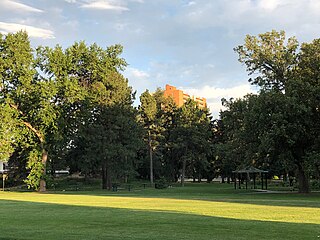
Alamo Placita is a historic district and unofficial neighborhood of Denver, Colorado, United States. It is named after Alamo Placita Park which is located on the north side of Speer Boulevard between Ogden and Emerson Streets.

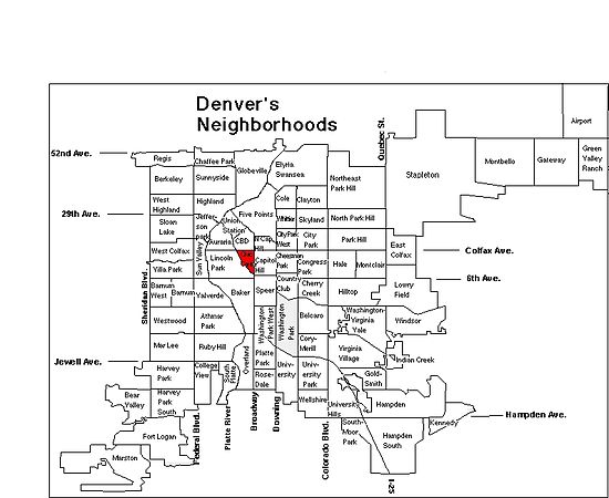
Located in the City and County of Denver, Colorado, the Capitol Hill neighborhood is bounded by Broadway, Downing Street, Colfax Avenue, and Seventh Avenue, which carry large volumes of traffic around the neighborhood. It is technically located in East Denver which begins immediately east of Broadway, the neighborhood's western boundary. Many consider the Cheesman Park neighborhood to be a part of the Capitol Hill neighborhood, but as defined by the city, Cheesman Park is a separate neighborhood. Denver also recognizes a statistical neighborhood called North Capitol Hill, also known as Uptown by some residents. Colfax Avenue is the border between these two neighborhoods.

Civic Center is a neighborhood in Denver, Colorado. The area is known as the center of the civic life in the city, with numerous institutions of arts, government, and culture as well as numerous festivals, parades, and protests throughout the year. The park bearing the same name is home to a fountain, several statues, and formal gardens, and includes a Greek amphitheater, a war memorial, and the Voorhies Memorial Seal Pond. It is well known for its symmetrical Neoclassical design.

Park Hill is a neighborhood in Denver, Colorado, U.S. Located in the northeastern quadrant of the city, it is bordered by Colorado Boulevard on the west, East Colfax Avenue on the south, Quebec Street on the east, and East 52nd Avenue on the north. The entire Park Hill neighborhood is located in the area known as East Denver. It is further divided by the City and County of Denver into three administrative neighborhoods, South Park Hill, North Park Hill, and Northeast Park Hill.
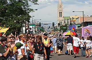
PrideFest is an annual Gay pride event held each June in Denver, honoring the culture and heritage of the lesbian, gay, bisexual, and transgender community in the State of Colorado. The first Denver PrideFest occurred in 1976, the same year the local community center, now known as the Center on Colfax, was founded. The Center organizes and produces the festival and parade each year. The event currently consists of a two-day festival at Civic Center Park, the Pride 5K, and culminates with a parade along Colfax Avenue. Denver PrideFest now draws 525,000 guests annually, making it the third largest pride festival and seventh largest pride parade in the United States.

Cherry Creek is a neighborhood in Denver, Colorado, U.S.. It has many newer residences mixed in with some of Denver's older homes.

The City and County of Denver, Colorado, is located at 39°43'35" North, 104°57'56" West in the Colorado Front Range region. The Southern Rocky Mountains lie to the west of Denver and the High Plains lie to the east.

Jefferson Park is a neighborhood and public park that overlooks Downtown Denver, Colorado from its perch across Interstate 25 (I-25). It is located in the area that is called North Denver. Views east from Jefferson Park take in Elitch Gardens Theme Park, The Children's Museum, Denver's Downtown Aquarium, Pepsi Center, the REI flagship store and other attractions in Downtown's Central Platte Valley. Downtown Denver and the Central Platte Valley are quickly accessed from Jefferson Park, using the 23rd Avenue overpass on I-25 and Water Street. In addition, the Light Rail C-Line is located by INVESCO Field at Mile High in the southern part of the neighborhood.

Highland is a distinct city-center neighborhood in Denver, Colorado, bounded by West 38th Avenue to the north, a Union Pacific Railroad line on the east, the South Platte River to the southeast, Speer Boulevard on the south, and Federal Boulevard on the west. The Highlands is sometimes used to refer to two separate city-center neighborhoods in Denver, Highland and West Highland, in although the two neighborhoods are distinct. Highland and West Highland are both in the area that is referred to as North Denver. is located immediately northwest of downtown. Note that the Highland neighborhood association has a slightly different definition with the easternmost boundary stopping at I-25. And the West Highland neighborhood to the immediate west of Highland, with the borders of 38th and 29th Avenues on the north and south and Federal and Sheridan Boulevards on the east and west. To distinguish between its immediately adjacent neighbor, West Highland, Highland is sometimes referred to as East Highland, Lower Highland or LoHi. The two together are casually called "the Highlands," a term which often falsely encompasses other Northwest Denver neighborhoods such as Jefferson Park, Sunnyside and Berkeley. Realtors have particularly pushed the inclusion of the recently gentrified Berkeley, located directly north of West Highland, as part of the Highlands, sometimes going so far as to refer to Berkeley and parts of Sunnyside as the "Upper Highlands". To add further confusion, within the Highlands neighborhoods there are several historic designations of various degrees, including Potter Highlands, Scottish Highlands and Highlands Park.

The street system of Denver, Colorado reflects the early history and original geography and present day layout of the City and County of Denver, Colorado.

There are 299 properties and districts listed on the National Register of Historic Places in Denver, the capital of the U.S. state of Colorado.

Berkeley is a city-center neighborhood in Denver, Colorado, located in the area traditionally called Northwest Denver, on the west side of Interstate 25 and just south of Interstate 70. The neighborhood is bounded by Federal Boulevard on the east, I-70 on the north, Sheridan Boulevard on the West and 38th avenue on the south. It is bordered by the West Highland neighborhood on the south and is often erroneously grouped together with the Highlands. The neighborhood contains two lakes surrounded by parks, one eponymous and Rocky Mountain Lake Park. Berkeley Park also contains the William Scheitler Recreation Center, run by the City and County of Denver and including both indoor and outdoor public pools. Berkeley has experienced rapid growth and rise in property values in the last 20 years and particularly since the closing of Elitch Gardens Amusement Park in October 1994. Particularly, Tennyson Street has become a commercial and cultural center for Northwest Denver, beginning in the current decade to rival Highland Square in nearby Highland. City Congressman Rick Garcia pushed for the further development of Tennyson Street in the November 2011 election season and succeeded in obtaining the voters' approval for $2.5 million in public works funding. Business owners on Tennyson from 48th Avenue to 38th Avenue currently collaborate in an Art Walk held on the first Friday of every month.

Lincoln Park is a neighborhood and public park close to downtown Denver, Colorado and the location of the Art District on Santa Fe. The neighborhood is one of Denver's oldest and is just to the south of the area where Denver was first settled in the 1850s. Many houses date from about 1900. The neighborhood is sometimes called "La Alma/Lincoln Park" or the West Side.

City Park West is a neighborhood of Denver, Colorado. It is a district of mostly single-family homes, small apartment buildings, and one very large hospital complex. The center of the district features the medical facilities of Presbyterian/St. Luke's Hospital, Exempla St. Joseph's Hospital, and a number of other medical office buildings and related facilities. Exempla Saint Joseph's Hospital has embarked on a major expansion project to create the newest, most modern hospital in Colorado. The new facility opened in December 2014.

Congress Park is a park and a neighborhood in the City and County of Denver, Colorado, United States. In 2010, the neighborhood had 10,235 residents and 5,724 households.

West Colfax is a neighborhood of Denver, Colorado. The neighborhood is located in the West Denver area. In 2015 the population of the neighborhood was 9,120, and there were 4,055 housing units.
The Hale neighborhood is a designated statistical neighborhood in the City and County of Denver, Colorado. Its boundaries are Colfax Avenue to the north, 6th Avenue to the south, Colorado Boulevard to the west, and Holly Street to the east.