
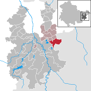
Leinefelde-Worbis is a town in the district of Eichsfeld, in northwestern Thuringia, Germany. The town was formed on March 16, 2004, from the former independent towns Leinefelde and Worbis along with the municipalities of Breitenbach and Wintzingerode. In July 2018 the former municipality of Hundeshagen, and in January 2019 Kallmerode was merged into Leinefelde-Worbis. The population before the amalgamation was 14,387 for Leinefelde, 5,541 for Worbis, 1,021 for Breitenbach and 614 for Wintzingerode. The 10 parts of Leinefelde-Worbis are Leinefelde, Worbis, Breitenbach, Kirchohmfeld, Birkungen, Beuren, Hundeshagen, Kaltohmfeld, Wintzingrode, Kallmerode and Breitenholz.
Dieterode is a municipality in the district Eichsfeld, Thuringia, Germany. It is part of the municipal association Ershausen/Geismar.

Hermsdorf is a town in the Saale-Holzland district of the state of Thuringia in eastern Germany. It is especially known for the motorway junction "Hermsdorfer Kreuz" where the two German autobahns A 4 and A 9 meet.

Schmölln is a town in Thuringia, Germany, landkreis of Altenburger Land. It lies on the river Sprotte.
Posterstein is a German municipality in the Thuringian Landkreis of Altenburger Land.

Gößnitz is a town in the Altenburger Land district, in Thuringia, Germany. It is situated on the river Pleiße, 12 km south of Altenburg, and 20 km northwest of Zwickau. Gößnitz received its town charter in 1718. It is known for the railroad junction of the Leipzig-Hof railway connection and the Central-Germany connection and its station prides itself having Europe's longest platform, as well as the Gößnitz Open-Air. The town's greatest prosperity was at the time of industrialization; Hence Viktor Grimm's representative malt factory from 1889 still characterizes the cityscape.

Orlamünde is a small town in the Saale-Holzland district, in Thuringia, Germany. It is part of the Verwaltungsgemeinschaft Südliches Saaletal.
Plaue is a town in the Ilm-Kreis district, in Thuringia, Germany. It is situated on the river Gera, 11 km north of Ilmenau, and 8 km southwest of Arnstadt. The former municipality Neusiß was merged into Plaue in January 2019. Plaue station lies on the Neudietendorf–Ritschenhausen railway.
Wurzbach is a town in the Saale-Orla-Kreis district, in southern Thuringia, Germany. It is situated 33 kilometres (21 mi) southeast of Saalfeld, and 45 kilometres (28 mi) northwest of Hof.

Weißensee is a town in the district of Sömmerda, in Thuringia, Germany. It is situated 6 km northwest of Sömmerda, and 25 km north of Erfurt. The former municipality Herrnschwende was merged into Weißensee in January 2019.

Tonndorf is a municipality in the Weimarer Land district of Thuringia, Germany. The nearest train station is the village München at the railway from Kranichfeld to Weimar, about four kilometers east of Tonndorf.

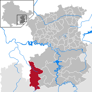
Gerstungen is a municipality in the Wartburgkreis district of Thuringia, Germany. It is 42 kilometers southwest of the geographic center of Germany, located in Niederdorla. In July 2018 the former municipalities of Marksuhl and Wolfsburg-Unkeroda were merged into Gerstungen.

Wutha-Farnroda is a municipality in the Wartburgkreis district of Thuringia, Germany.

Georgenthal is a municipality in the district of Gotha, in Thuringia, Germany. The former municipalities Leinatal, Hohenkirchen and Petriroda were merged into Georgenthal in December 2019. The former municipality Herrenhof was merged into Georgenthal in January 2024.
Seelingstädt is a municipality in the district of Greiz, in Thuringia, Germany. It is the seat of the municipal association of Ländereck.

Freienorla is located in the German state of Thuringia. Although quite small and obscure, the municipality is known locally for its Gothic church as well as its lower mill, a watermill facility thought to be built in the tenth century. The Orlabahn railroad has a station located in Freienorla. Neighboring towns include Jena and Eisenberg. Freienorla is located 145 miles from the capital of Berlin.
Hohenwarte is a municipality in the district Saalfeld-Rudolstadt, in Thuringia, Germany.

Probstzella is a municipality in the district Saalfeld-Rudolstadt, in Thuringia, Germany.

Nesse-Apfelstädt is a municipality in the district of Gotha, in Thuringia, Germany. It was formed by the merger of the previously independent municipalities Apfelstädt, Gamstädt, Ingersleben and Neudietendorf, on 1 December 2009.
Hildburghausen II – Sonneberg II is an electoral constituency represented in the Landtag of Thuringia. It elects one member via first-past-the-post voting. Under the current constituency numbering system, it is designated as constituency 20. It covers the eastern part of Hildburghausen district and the northern part of Sonneberg district.


