Sonneberg

Last updated
Sonneberg
Rathaus Sonneberg2.jpg
Town hall
Wappen Sonneberg.svg
Location of Sonneberg within Sonneberg district
Sonneberg in SON.svgSteinach
Germany adm location map.svg
Red pog.svg
Sonneberg
Thuringia location map.svg
Red pog.svg
Sonneberg
Coordinates: 50°21′N11°10′E / 50.350°N 11.167°E / 50.350; 11.167
Country Germany
State Thuringia
District Sonneberg
Government
   Mayor (202228) Dr. Heiko Voigt [1] (Ind.)
Area
  Total84.69 km2 (32.70 sq mi)
Elevation
400 m (1,300 ft)
Population
 (2022-12-31) [2]
  Total23,507
  Density280/km2 (720/sq mi)
Time zone UTC+01:00 (CET)
  Summer (DST) UTC+02:00 (CEST)
Postal codes
96515
Dialling codes 03675, 036762, 036703
Vehicle registration SON, NH
Website www.sonneberg.de

Sonneberg in Thuringia, Germany, is the seat of the Sonneberg district. It is in the Franconian south of Thuringia, neighboring its Upper Franconian twin town Neustadt bei Coburg.

Contents

Sonneberg became known as the "world toy city", and is home to the German Toy Museum  [ de ] and the Sonneberg observatory, founded in 1925. The Thuringian Slate Mountains border the city, with the Franconian Forest to the east. [3]

History

"The Sonneberg Castle was also called Sonneberg Castle or the Haus zu Sonneberg in old documents. In 480 Süne or Süno, Duke of Franconia, built this castle because of the Thuringian incursions ..." so it says on page 64 in the topography of the Duke of Saxe-Meiningen's share in the Duchy of Coburg from the year 1781. This not uncritical representation is based on the history of the Franks by Abbot Johannes Trithemius from 1514. [4]

The name Sonneberg was first mentioned in documents in 1207. It goes back to the noble family of the Lords of Sonneberg, which is documented in the 12th and 13th centuries and founded a settlement below the Sonneberg Castle, which originally consisted of the estate and two hamlets, the village of "Alt-Rötin, presumed to be in Herrnau "And the" Stätlein zu Rötin under the Sonneberg Castle". The Lords of Sonneberg were ministerials in the service of the Dukes of Andechs-Meranien, who, as a Bavarian noble family, established a lordly administration in the region around Sonneberg and Coburg.

The quarrying of whetstones and slate for slates has been documented since 1500. From the long-established wooden goods manufacture, the production of the Sonneberg toys known as Nuremberg trinkets developed from the 16th century onwards. Around 1700, the Dressel company, and from 1873 Cuno & Otto Dressel, the largest manufacturer and exporter of toys was founded in Sonneberg. From 1805, with the introduction of paper mache, Sonneberg developed into a toy production center with international status, especially in the manufacture of dolls (see also: F. M. Schilling). In 1840 a city fire destroyed the old city center around the market square in what is now the Upper City. In 1883 the industrial school was opened in Mühlgasse 4, where artistic porcelain, glass and toy design was taught.

Christmas sleigh at the 1900 Paris Exposition Weltausstellung Paris 1900.jpg
Christmas sleigh at the 1900 Paris Exposition

The term “world toy city” was coined around 1913 due to the share of Sonneberg's production on the world market. Before the First World War, around 20% of the toys traded on the world market in the Sonneberg area were mainly manufactured at home. [5] In addition to the term world toy city, Sonneberg advanced to become the “workshop of the Santa Claus”. From the 1870s onwards, the toy industry did not respond to increasing demand and falling sales prices with a transition to industrial production in larger factories using innovative techniques. Even if exports to the US rose by around 600% between 1865 and 1885, in 1880 85% of the companies had just four employees. [10] It was the number of these traditionally working small and micro-businesses that increased tremendously in response to the increased demand. In 1880 there were a total of 321 companies. 1899, almost 20 years later, 2395, an increase of 746%. [6]

One of the heydays of the toy industry led to the development of the station square with representative buildings in the 1920s. First, the US company Halbourn built a six-story trading house that has been owned by the AOK since 1925. Opposite it, in 1926, the American department store company F. W. Woolworth Company, which had been purchasing locally since 1880, built a trading and warehouse for the purchase and export of toys and Christmas tree decorations. The five-storey reinforced concrete building with its own siding was built according to plans by the Sonneberg architect Walter Buchholz.

In divided post-war Germany, Sonneberg found itself within the borders of East Germany, cut off from its large neighbouring town of Coburg, Bavaria in West Germany and could only face north economically. It was served by an unnaturally winding railway route and thus became somewhat isolated from the rest of East Germany. Sonneberg Hauptbahnhof is served by the Coburg–Sonneberg line.

After the fall of the Wall, toy shops were privatized or re-privatized, if they still existed. In 2002 the Thuringian Day took place in Sonneberg. The city became a member of the European metropolitan region of Nuremberg in July 2012, initially on a trial basis, and has been a permanent member since October 2013. [7]

The 14th Franconian Day was celebrated on July 6 and 7, 2019 by the district of Upper Franconia together with the Bavarian state government and the two host cities Sonneberg and Neustadt bei Coburg for the first time across borders with over 25,000 visitors under the motto: GEMEINSAM.FRÄNKISCH.STARK.

Sonneberg is a location with a close network with hydrogen initiatives in the metropolitan region of Central Germany and it is a member of the European metropolitan region of Nuremberg. Thus, Sonneberg has a "hinge function" to the important economic areas between the Main and Elbe. The HySon Institute for Applied Hydrogen Research emerged in February 2021 from a network of actors from business and science. There are 50 partners in total. Their common goal is to close the gap between research and application. [8]

Subdivisions

The town Sonneberg consists of the following subdivisions:

  • Bettelhecken
  • Hönbach
  • Hüttensteinach
  • Köppelsdorf
  • Malmerz
  • Mürschnitz
  • Neufang
  • Oberlind
  • Obere Stadt
  • Steinbach
  • Untere Stadt
  • Unterlind
  • Wehd
  • Wolkenrasen

Since 31 December 2013, when the former municipality Oberland am Rennsteig was merged into Sonneberg, the following villages also form part of Sonneberg: Haselbach, Eschenthal, Hasenthal, Hüttengrund and Spechtsbrunn.

Sonneberg Sonneberg--Gustav-Koenigstr2.jpg
Sonneberg

Number of inhabitants

Population Statistics Sonneberg.png

1829-1981

  • 1829: 3,028
  • 1895: 12,167
  • 1905: 15,003
  • 1946: 21,534
  • 1950: 30,182
  • 1960: 28,936
  • 1981: 28,733

1984-1999

  • 1984: 28,440
  • 1994: 25,880
  • 1995: 25,481
  • 1996: 25,297
  • 1997: 25,151
  • 1998: 24,951
  • 1999: 24,892

2000-2006

  • 2000: 24,837
  • 2001: 24,690
  • 2002: 24,582
  • 2003: 24,246
  • 2004: 24,026
  • 2005: 23,805
  • 2006: 23,681

2007-2013

  • 2007: 23,252
  • 2008: 22,807
  • 2009: 22,529
  • 2010: 22,356
  • 2011: 22,222
  • 2012: 21,737
  • 2013: 23,796

2014-2020

  • 2014: 23,620
  • 2015: 23,736
  • 2016: 23,804
  • 2017: 23,756
  • 2018: 23,830
  • 2019: 23,516
  • 2020: 23,229
Data source since 1994: Thuringia statistical office

Notable people

August Schleicher August Schleicher.jpg
August Schleicher
Cuno Hoffmeister Cuno Hoffmeister.jpg
Cuno Hoffmeister

Related Research Articles

<span class="mw-page-title-main">Franconia</span> Cultural region of Germany in Bavaria

Franconia is a region of Germany, characterised by its culture and East Franconian dialect . Franconia is made up of the three Regierungsbezirke of Lower, Middle and Upper Franconia in Bavaria, the adjacent, Franconian-speaking, South Thuringia, south of the Thuringian Forest—which constitutes the language boundary between Franconian and Thuringian—and the eastern parts of Heilbronn-Franconia in Baden-Württemberg.

<span class="mw-page-title-main">Thuringia</span> State in Germany

Thuringia, officially the Free State of Thuringia, is a state of central Germany, covering 16,171 square kilometres (6,244 sq mi), the sixth smallest of the sixteen German states. It has a population of about 2.1 million.

<span class="mw-page-title-main">Saxe-Coburg and Gotha</span> Collective name for the duchies of Saxe-Coburg and Saxe-Gotha in Germany

Saxe-Coburg and Gotha, or Saxe-Coburg-Gotha, was an Ernestine duchy in Thuringia ruled by a branch of the House of Wettin, consisting of territories in the present-day states of Thuringia and Bavaria in Germany. It lasted from 1826 to 1918. In November 1918, Charles Edward, Duke of Saxe-Coburg and Gotha, was forced to abdicate. In 1920, the northern part of the duchy was merged with six other Thuringian free states to form the Free State of Thuringia: Saxe-Weimar-Eisenach, Saxe-Altenburg and Saxe-Meiningen, Schwarzburg-Rudolstadt and Schwarzburg-Sondershausen, as well as the People's State of Reuss. The southern part of the duchy, as southernmost of the Thuringian states, was the only one which, after a referendum, became part of the Free State of Bavaria.

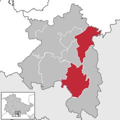
Hildburghausen is a district in Thuringia, Germany. It is bounded by the district of Schmalkalden-Meiningen, the city of Suhl, the districts of Ilm-Kreis, Saalfeld-Rudolstadt and Sonneberg, and the state of Bavaria. Located roughly halfway between the mountain chains of the Rhön and the Thuringian Forest, the district is densely forested and covered by hilly countryside. Its territory is similar to that of the former Ernestine duchy, Saxe-Hildburghausen.

Kronach is a Landkreis (district) in Bavaria, Germany. It is bounded by the districts of Hof, Kulmbach, Lichtenfels and Coburg, and the state of Thuringia.

<span class="mw-page-title-main">Saalfeld</span> Town in Thuringia, Germany

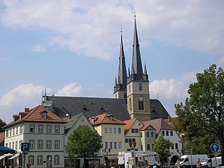
Saalfeld is a town in Germany, capital of the Saalfeld-Rudolstadt district of Thuringia. It is best known internationally as the ancestral seat of the Saxe-Coburg and Gotha branch of the Saxon House of Wettin.

<span class="mw-page-title-main">Waltershausen</span> Town in Thuringia, Germany

Waltershausen is a town in the south-western part of the district of Gotha in the state of Thuringia, Germany.

<span class="mw-page-title-main">Ilmenau</span> Town in Thuringia, Germany

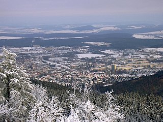
Ilmenau is a town in Thuringia, central Germany. It is the largest town within the Ilm district with a population of 38,600, while the district capital is Arnstadt. Ilmenau is located approximately 33 km south of Erfurt and 135 km north of Nuremberg within the Ilm valley at the northern edge of the Thuringian Forest at an elevation of 500 metres.

<span class="mw-page-title-main">Schalkau</span> Town in Thuringia, Germany

Schalkau is a town in the district of Sonneberg, in Thuringia, Germany. It is situated 13 km west of Sonneberg, and 15 km north of Coburg. The former municipality Bachfeld was merged into Schalkau in December 2019.

<span class="mw-page-title-main">House of Henneberg</span> Noble family

The House of Henneberg was a medieval German comital family (Grafen) which from the 11th century onwards held large territories in the Duchy of Franconia. Their county was raised to a princely county in 1310.

<span class="mw-page-title-main">Rennsteig</span> Long-distance trail in Germany

The Rennsteig is a ridge walk as well as a historical boundary path in the Thuringian Forest, Thuringian Highland and Franconian Forest in Central Germany. The long-distance trail runs for about 170 km from Eisenach and the Werra valley in the northwest to Blankenstein and the Selbitz river in the southeast.

<span class="mw-page-title-main">Eisenach–Lichtenfels railway</span>

The Eisenach–Lichtenfels railway is a single-tracked main line with a standard gauge of 1,435 mm in Thuringia and Bavaria in southern and central Germany, that runs mostly along the river Werra. It runs from Eisenach via Meiningen to Eisfeld and, formerly, continued to Coburg and Lichtenfels. It was opened in 1858 and is one of the oldest railways in Germany. The railway company that built it, the Werra Eisenbahngesellschaft with its headquarters in Meiningen was also often called the Werrabahn. The company also ran various lines branching off the Werra Railway.

<span class="mw-page-title-main">Sonneberg (Thür) Hauptbahnhof</span>

Sonneberg (Thür) Hauptbahnhof is a railway station for the city of Sonneberg in the German state of Thuringia and is on the Coburg–Sonneberg line. The station was built as part of the construction of the Hinterland Railway and still plays a central role in public transport of Sonneberg and the surrounding area. It was built in 1907 to replace the old station, which was built in 1857 and 1858 by the Werra Railway Company, together with the single-track Coburg–Sonneberg line, a branch line of the Werra Railway.

<span class="mw-page-title-main">Röthen</span> River in Germany

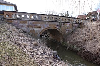
Röthen is a river of Thuringia and Bavaria, Germany. It passes through Sonneberg and Neustadt bei Coburg, and flows into the Itz near Rödental.

<span class="mw-page-title-main">Itzgründisch dialect</span> East Franconian dialect of Germany

Itzgründisch is an East Franconian dialect, which is spoken in the eponymous Itz Valley and its tributaries of Grümpen, Effelder, Röthen/Röden, Lauter, Füllbach and Rodach, the valleys of the Neubrunn, Biber and the upper Werra and in the valley of Steinach. In the small language area, which extends from the Itzgrund in Upper Franconia to the southern side of the Thuringian Highlands, East Franconian still exists in the original form. Because of the remoteness of the area, this isolated by the end of the 19th century and later during the division of Germany, this language has kept many linguistic features to this day. Scientific study of the Itzgründisch dialect was made for the first time, in the middle of the 19th century, by the linguist August Schleicher.

<span class="mw-page-title-main">Free State of Coburg</span>

The Free State of Coburg emerged from the Duchy of Saxe-Coburg and Gotha at the end of the First World War. It existed from November 1918 until its union with the Free State of Bavaria on 1 July 1920.

<span class="mw-page-title-main">Ernst Heubach</span>

Ernst Heubach was a company in Köppelsdorf, Thuringia, Germany, that manufactured porcelain-headed bisque dolls from 1885 onwards

<span class="mw-page-title-main">History of Franconia</span>

Franconia is a region that is not precisely defined, but which lies in the north of the Free State of Bavaria, parts of Baden-Württemberg and South Thuringia and Hesse in Germany. It is characterised by its own cultural and linguistic heritage. Its history began with the first recorded human settlement about 600,000 years ago. Thuringii, Alemanni and Franks, who gave the region its name, settled the area in the Early Middle Ages. From the mid-9th century, the Stem Duchy of Franconia emerged as one of the five stem duchies of the Empire of East Francia. On 2 July 1500, during the reign of Emperor Maximilian I, as part of the Imperial Reform, the empire was divided into Imperial Circles. The Franconian Circle, which was formed as a result of this restructuring, became decisive in the creation of a Franconian national identity. A feature of Franconia in the Middle Ages and Early Modern Period was its Kleinstaaterei, an extreme fragmentation into little states and territories. In the 19th century under Napoleon, large parts of Franconia were incorporated into the newly created Kingdom of Bavaria.

<span class="mw-page-title-main">South Thuringia</span> Southern region of the German state of Thuringia

South Thuringia refers to all the Franconia regions in the German Free State of Thuringia south of the Rennsteig and the Salzbogen, but including the entire former county of Bad Salzungen. The region is, if the Eisenach area is excluded, almost identical with the Southwest Thuringian Planning Region in the state of Thuringia.

The State of Thuringia was a state of the German Empire in the Weimar Republic and the Nazi era, as well as a state of the Soviet occupation zone in Germany and the East Germany. The state capital was Weimar, the largest city Gera.

References

  1. Gewählte Bürgermeister - aktuelle Landesübersicht, Freistaat Thüringen, accessed 10 November 2022.
  2. "Bevölkerung der Gemeinden, erfüllenden Gemeinden und Verwaltungsgemeinschaften in Thüringen Gebietsstand: 31.12.2022" (in German). Thüringer Landesamt für Statistik. June 2023.
  3. "Landschaftssteckbrief Frankenwald". Bundesamt für Naturschutz.
  4. De origine gentis Francorum compendium, 1514 – An abridged history of the Franks / Johannes Trithemius; AQ-Verlag, Dudweiler 1987; ISBN 978-3-922441-52-6.
  5. Oskar Stillich: Die Spielwaren-Hausindustrie des Meininger Oberlandes. Verlag Fischer, Jena 1899.
  6. David D. Hamlin: Work and Play. The Production and Consumption of Toys in Germany, 1870–1914. University of Michigan 2007, S. 87.
  7. Metropolregion Nürnberg: Thüringen macht mit, archived from the original on 2015-05-01, retrieved 2020-05-03
  8. "Sonneberg als Forschungsstandort für Wasserstoff - Spatenstich bei HySon". MDR. 2021-08-27.