
The Saale, also known as the Saxon Saale and Thuringian Saale, is a river in Germany and a left-bank tributary of the Elbe. It is not to be confused with the smaller Franconian Saale, a right-bank tributary of the Main, or the Saale in Lower Saxony, a tributary of the Leine.
Ilm-Kreis is a district in Thuringia, Germany. It is bounded by the city of Erfurt, the districts of Weimarer Land, Saalfeld-Rudolstadt and Hildburghausen, the city of Suhl, and the districts of Schmalkalden-Meiningen and Gotha. It is named after the river Ilm, flowing through the district.

Bad Blankenburg is a spa town in the district of Saalfeld-Rudolstadt, in Thuringia, Germany. It is situated 6 km southwest of Rudolstadt, and 37 km southeast of Erfurt. It is most famous for being the location of the first kindergarten of Friedrich Wilhelm August Fröbel, in 1837.
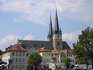
Saalfeld is a town in Germany, capital of the Saalfeld-Rudolstadt district of Thuringia. It is best known internationally as the ancestral seat of the Saxe-Coburg and Gotha branch of the Saxon House of Wettin.

Arnstadt is a town in Ilm-Kreis, Thuringia, Germany, on the river Gera about 20 kilometres (12 mi) south of Erfurt, the capital of Thuringia. Arnstadt is one of the oldest towns in Thuringia, and has a well-preserved historic centre with a partially preserved town wall. The town is nicknamed Das Tor zum Thüringer Wald because of its location on the northern edge of that forest. Arnstadt has a population of approximately 27,000.
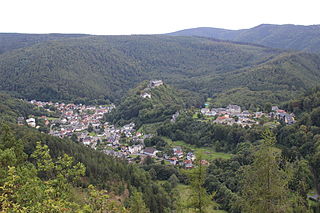
Schwarzburg is a municipality in the valley of the Schwarza in the district Saalfeld-Rudolstadt in Thuringia, in central Germany.
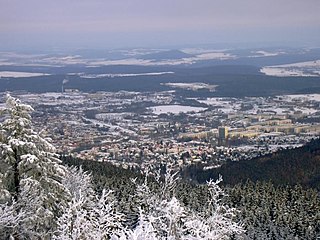
Ilmenau is a town in Thuringia, central Germany. It is the largest town within the Ilm district with a population of 38,600, while the district capital is Arnstadt. Ilmenau is located approximately 33 km south of Erfurt and 135 km north of Nuremberg within the Ilm valley at the northern edge of the Thuringian Forest at an elevation of 500 metres.
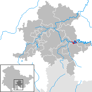
Pößneck is a town in the Saale-Orla-Kreis district, in Thuringia, Germany. It is situated 19 km east of Rudolstadt, and 26 km south of Jena.

Bad Frankenhausen is a spa town in the German state of Thuringia. It is located at the southern slope of the Kyffhäuser mountain range, on an artificial arm of the Wipper river, a tributary of the Unstrut. Because of the nearby Kyffhäuser monument dedicated to Emperor Frederick Barbarossa, it is nicknamed Barbarossastadt. The municipality includes the villages of Seehausen, Udersleben, Esperstedt and Ichstedt and Ringleben.

Gräfenthal is a town in the district of Saalfeld-Rudolstadt in Thuringia, Germany.

Leutenberg is a town in the district of Saalfeld-Rudolstadt, in Thuringia, Germany. It is situated in the Thuringian Forest, 18 km (11 mi) southeast of Saalfeld.

Stadtilm is a town in the Ilm-Kreis district, in Thuringia, Germany. It is situated on the river Ilm, 15 km northeast of Ilmenau, and 11 km southeast of Arnstadt. In July 2018 the former municipality of Ilmtal was merged into Stadtilm.

Jenalöbnitz is a municipality in the district Saale-Holzland, in Thuringia, Germany.
Hohenwarte is a municipality in the district Saalfeld-Rudolstadt, in Thuringia, Germany.

Lichte is a village and a former municipality in the district of Sonneberg in Thuringia, Germany, close to the Thuringian Rennsteig. Formerly in the district Saalfeld-Rudolstadt, it is part of the town Neuhaus am Rennweg since January 2019.

Friedensburg Castle is an early 16th-century castle overlooking the valley of the Sormitz at Leutenberg in southeast Thuringia, Germany. It was formerly the residence of the Counts of Schwarzburg-Leutenberg and today is a dermatological medical facility.

Uwe Mundlos was a German neo-Nazi, right-wing terrorist and serial killer. Together with Uwe Böhnhardt and Beate Zschäpe, he formed the nucleus of the terrorist group National Socialist Underground (NSU), which was responsible for 10 murders, 43 attempted murders, 3 explosive attacks, and 15 bank robberies in Germany between 1998 and 2011. He died after a bank robbery led to his discovery by police, presumably by suicide.

Prince Frederick Charles of Schwarzburg-Rudolstadt was a German Natural History collector, and from 1790 until his death the reigning Prince of Schwarzburg-Rudolstadt.
The Thuringian Counts' War, or Thuringian Counts' Feud was a conflict between several ancient aristocratic families and the House of Wettin for supremacy in Thuringia. The war lasted from 1342 to 1346. The conflict is also called by various other names in English sources including War of the Thuringian Counts and Thuringian Comital War.
Helmut Roewer is a German lawyer and author. He served between 1994 and 2000 as president of the regional office for protection of the constitution in Thuringia. This is a state-level security agency. Controversy in respect of his time in office has persisted, although he himself robustly rejects most of the criticisms of his decisions made at that time.


