The Saale, also known as the Saxon Saale and Thuringian Saale, is a river in Germany and a left-bank tributary of the Elbe. It is not to be confused with the smaller Franconian Saale, a right-bank tributary of the Main, or the Saale in Lower Saxony, a tributary of the Leine.
Ilm-Kreis is a district in Thuringia, Germany. It is bounded by the city of Erfurt, the districts of Weimarer Land, Saalfeld-Rudolstadt and Hildburghausen, the city of Suhl, and the districts of Schmalkalden-Meiningen and Gotha. It is named after the river Ilm, flowing through the district.
Saale-Orla is a Kreis (district) in the east of Thuringia, Germany. Neighboring districts are the districts Saale-Holzland, Greiz, the Vogtlandkreis in Saxony, the Bavarian districts Hof and Kronach, and the district Saalfeld-Rudolstadt.
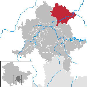
Saalfeld-Rudolstadt is a Kreis (district) in the south of Thuringia, Germany. Neighboring districts are the districts Weimarer Land, Saale-Holzland, Saale-Orla, the district Kronach in Bavaria, and the districts Sonneberg, Hildburghausen and Ilm-Kreis.
Weimarer Land is a Landkreis (district) in the east of Thuringia, Germany. Neighboring districts are the district Burgenlandkreis in Saxony-Anhalt, the district Saale-Holzland and the district-free city Jena, the district Saalfeld-Rudolstadt, Ilm-Kreis, and the district-free city Erfurt. The district-free city Weimar is completely enclosed by the district.

Bad Blankenburg is a spa town in the district of Saalfeld-Rudolstadt, in Thuringia, Germany. It is situated 6 km southwest of Rudolstadt, and 37 km southeast of Erfurt. It is most famous for being the location of the first kindergarten of Friedrich Wilhelm August Fröbel, in 1837.
Saalfeld is a town in Germany, capital of the Saalfeld-Rudolstadt district of Thuringia. It is best known internationally as the ancestral seat of the Saxe-Coburg and Gotha branch of the Saxon House of Wettin.
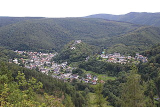
Schwarzburg is a municipality in the valley of the Schwarza in the district Saalfeld-Rudolstadt in Thuringia, in central Germany.
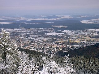
Ilmenau is a town in Thuringia, central Germany. It is the largest town within the Ilm district with a population of 38,600, while the district capital is Arnstadt. Ilmenau is located approximately 33 km south of Erfurt and 135 km north of Nuremberg within the Ilm valley at the northern edge of the Thuringian Forest at an elevation of 500 metres.

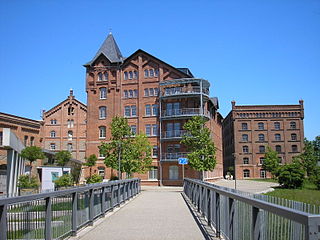
Rudolstadt is a town in the German federal state Thuringia, within the Thuringian Forest, to the southwest, and to Jena and Weimar to the north.
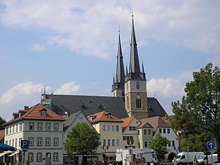
Pößneck is a town in the Saale-Orla-Kreis district, in Thuringia, Germany. It is situated 19 km east of Rudolstadt, and 26 km south of Jena.

Bad Frankenhausen is a spa town in the German state of Thuringia. It is located at the southern slope of the Kyffhäuser mountain range, on an artificial arm of the Wipper river, a tributary of the Unstrut. Because of the nearby Kyffhäuser monument dedicated to Emperor Frederick Barbarossa, it is nicknamed Barbarossastadt. The municipality includes the villages of Seehausen, Udersleben, Esperstedt and Ichstedt and Ringleben.

Bad Lobenstein is a spa town in the Saale-Orla-Kreis district, in Thuringia, Germany with a population of about 6,000 inhabitants. Until 2005, the town was named Lobenstein.

Leutenberg is a town in the district of Saalfeld-Rudolstadt, in Thuringia, Germany. It is situated in the Thuringian Forest, 18 km (11 mi) southeast of Saalfeld.

Stadtilm is a town in the Ilm-Kreis district, in Thuringia, Germany. It is situated on the river Ilm, 15 km northeast of Ilmenau, and 11 km southeast of Arnstadt. In July 2018 the former municipality of Ilmtal was merged into Stadtilm.

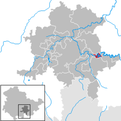
Kaulsdorf is a municipality in the district Saalfeld-Rudolstadt, in Thuringia, Germany.

Jenalöbnitz is a municipality in the district Saale-Holzland, in Thuringia, Germany.
Uhlstädt-Kirchhasel is a municipality in the district Saalfeld-Rudolstadt, in Thuringia, Germany. On 1 December 2007, the former municipalities Großkochberg and Heilingen were incorporated by Uhlstädt-Kirchhasel. The valley of the river Saale is the centre of Uhlstädt-Kirchhasel. Both Uhlstädt and Kirchhasel are villages inside this valley, which divides the municipality into a northern and a southern part. The nearest bigger towns are Rudolstadt, Saalfeld and Jena.
Saalfeld-Rudolstadt I is an electoral constituency represented in the Landtag of Thuringia. It elects one member via first-past-the-post voting. Under the current constituency numbering system, it is designated as constituency 28. It covers the western part of Saalfeld-Rudolstadt.
Saalfeld-Rudolstadt II is an electoral constituency represented in the Landtag of Thuringia. It elects one member via first-past-the-post voting. Under the current constituency numbering system, it is designated as constituency 29 and It covers the eastern part of Saalfeld-Rudolstadt.