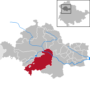
Dingelstädt is a town in the district of Eichsfeld in Thuringia, Germany. It is situated on the upper course of the river Unstrut, 8 km (5 mi) south of Leinefelde-Worbis and 15 km (9 mi) northwest of Mühlhausen. The former municipalities Helmsdorf, Kefferhausen, Kreuzebra and Silberhausen were merged into Dingelstädt in January 2019. In January 2023 Dingelstädt absorbed the villages Bickenriede and Zella from the former municipality Anrode, and Beberstedt and Hüpstedt from the former municipality Dünwald. In January 2024 it absorbed the village Struth from the former municipality Rodeberg.

Niederorschel is a municipality in the district of Eichsfeld in Thuringia, Germany. The former municipalities Deuna, Gerterode, Hausen and Kleinbartloff were merged into Niederorschel in January 2019. It further includes the localities of Niederorschel, Oberorschel, and Rüdigershagen.
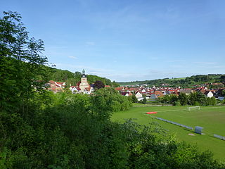
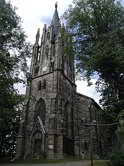
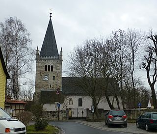
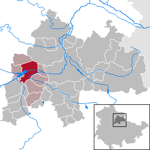
Geisleden is a municipality in the district of Eichsfeld in Thuringia, Germany. It is located about 4 kilometres (2.5 mi) southeast of Heiligenstadt in the valley formed by the river Geislede. Other neighboring towns are Westhausen in the north, Kreuzebra to the east, and Heuthen toward the southeast.
Uder is a municipality in the district of Eichsfeld in Thuringia, Germany. On 1 January 2024, the former municipality Uder was merged with the former municipalities Birkenfelde, Eichstruth, Lenterode, Lutter, Mackenrode, Röhrig, Schönhagen, Steinheuterode, Thalwenden and Wüstheuterode to form the current municipality Uder.
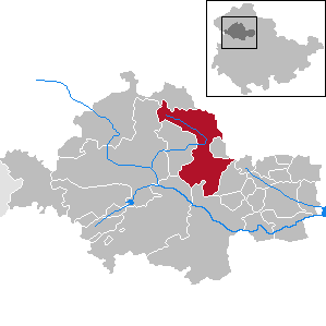
Unstruttal is a municipality in the Unstrut-Hainich-Kreis district of Thuringia, Germany. It was created in September 1995 by the merger of the former municipalities Ammern, Dachrieden, Eigenrode, Horsmar, Kaisershagen and Reiser. In January 2023 Unstruttal absorbed the former municipality Menteroda, the villages Dörna and Lengefeld from the former municipality Anrode, and Zaunröden from the former municipality Dünwald.

Bad Salzungen is a town in Thuringia, Germany. It is the capital of the Wartburgkreis district.

Bad Sulza is a town in the Weimarer Land district, in Thuringia, Germany. It is situated on the river Ilm, 15 km southwest of Naumburg, and 18 km north of Jena.

Kindelbrück is a municipality in the district of Sömmerda, in Thuringia, Germany. It is situated on the river Wipper, 12 km north of Sömmerda. The former municipalities Bilzingsleben, Frömmstedt and Kannawurf were merged into Kindelbrück in January 2019. In January 2023 Kindelbrück absorbed the former municipality Riethgen.

Georgenthal is a municipality in the district of Gotha, in Thuringia, Germany. The former municipalities Leinatal, Hohenkirchen and Petriroda were merged into Georgenthal in December 2019. The former municipality Herrenhof was merged into Georgenthal in January 2024.

Ilmtal-Weinstraße is a municipality in the district Weimarer Land, in Thuringia, Germany. It was named after the river Ilm, that flows through the municipality. It was formed on 31 December 2013 by the merger of the former municipalities Liebstedt, Mattstedt, Niederreißen, Niederroßla, Nirmsdorf, Oberreißen, Oßmannstedt, Pfiffelbach and Willerstedt. Before, these municipalities had cooperated in the Verwaltungsgemeinschaft Ilmtal-Weinstraße, which was disbanded. The seat of the municipality and of the former Verwaltungsgemeinschaft is in Pfiffelbach. The former municipalities Kromsdorf, Rohrbach and Leutenthal were merged into Ilmtal-Weinstraße in January 2019.

Albersdorf is a municipality in the Saale-Holzland district of Thuringia, Germany. As of 2018, the population is 288.
Straußfurt is a municipality in the Sömmerda district of Thuringia, Germany. The former municipality Henschleben was merged into Straußfurt in December 2019.

Schwarzatal is a town and a municipality in the district Saalfeld-Rudolstadt, in Thuringia, Germany. It was created with effect from 1 January 2019 by the merger of the former municipalities of Mellenbach-Glasbach, Meuselbach-Schwarzmühle and Oberweißbach. The name refers to the river Schwarza.
Unstrut-Hainich is a municipality in the district Unstrut-Hainich-Kreis, in Thuringia, Germany. It was created with effect from 1 January 2019 by the merger of the former municipalities of Altengottern, Flarchheim, Großengottern, Heroldishausen, Mülverstedt and Weberstedt. On 1 January 2024, it absorbed the former municipality Schönstedt. The name refers to the river Unstrut and the hill chain Hainich.

Amt Wachsenburg is a municipality in the district Ilm-Kreis, in Thuringia, Germany. The municipality is named after the Wachsenburg Castle which is located in its center. It was formed on 31 December 2012 from the former municipalities Wachsenburggemeinde and Ichtershausen. The former municipality Kirchheim was merged into Amt Wachsenburg in January 2019, and Rockhausen in December 2019. It consists of the villages Bechstedt-Wagd, Bittstädt, Eischleben, Haarhausen, Holzhausen, Ichtershausen, Kirchheim, Rehestädt, Rockhausen, Röhrensee, Sülzenbrücken, Thörey and Werningsleben.

Nessetal is a municipality in the district of Gotha, in Thuringia, Germany. It was created with effect from 1 January 2019 by the merger of the former municipalities of Ballstädt, Brüheim, Bufleben, Friedrichswerth, Goldbach, Haina, Hochheim, Remstädt, Wangenheim, Warza and Westhausen. These former municipalities are now Ortschaften of the municipality Nessetal. The name refers to the river Nesse.

Rosenthal am Rennsteig is a municipality in the district Saale-Orla-Kreis, in Thuringia, Germany. It was created with effect from 1 January 2019 by the merger of the former municipalities of Birkenhügel, Blankenberg, Blankenstein, Harra, Neundorf bei Lobenstein, Pottiga and Schlegel.
Nottertal-Heilinger Höhen is a town in the Unstrut-Hainich-Kreis district, in Thuringia, Germany. It was created with effect from 31 December 2019 by the merger of the former municipalities of Schlotheim, Bothenheilingen, Issersheilingen, Kleinwelsbach, Neunheilingen and Obermehler. It takes its name from the river Notter, that flows through the municipality, and the Heilingen hills.

Amt Creuzburg is a town in the Wartburgkreis district, in Thuringia, Germany. It was created with effect from 31 December 2019 by the merger of the former municipalities of Creuzburg, Ebenshausen and Mihla. On 1 January 2024, it absorbed the former municipality Frankenroda. It takes its name from the town Creuzburg, the centre of the new municipality.

Grammetal is a municipality in the Weimarer Land district, in Thuringia, Germany. It was created with effect from 31 December 2019 by the merger of the former municipalities of Bechstedtstraß, Daasdorf am Berge, Hopfgarten, Isseroda, Mönchenholzhausen, Niederzimmern, Nohra, Ottstedt am Berge and Troistedt, that had previously coöperated in the Verwaltungsgemeinschaft Grammetal. It takes its name from the river Gramme, that flows through the municipality.