Interstate 99 (I-99) is an interstate highway in the United States with two segments: one located in central Pennsylvania and the other in southern New York. The southern terminus of the route is near exit 146 of the Pennsylvania Turnpike (I-70/I-76) north of Bedford, where the road continues south as U.S. Route 220 (US 220). The northern terminus of the Pennsylvania segment is at an at-grade intersection with Musser Lane just before reaching I-80 near Bellefonte. The New York segment follows US 15 from the Pennsylvania–New York border to an interchange with I-86 in Corning. Within Pennsylvania, I-99 passes through Altoona and State College—the latter home to the Pennsylvania State University—and is entirely concurrent with US 220. Long-term plans call for the two segments of I-99 to be connected using portions of I-80, US 220, and US 15 through Pennsylvania.

The Appalachian Trail, also called the A.T., is a hiking trail in the Eastern United States, extending almost 2,200 miles (3,540 km) between Springer Mountain in Georgia and Mount Katahdin in Maine, and passing through 14 states. The Appalachian Trail Conservancy claims the Appalachian Trail to be the longest hiking-only trail in the world. More than three million people hike segments of the trail each year.

Interstate 91 (I-91) is an Interstate Highway in the New England region of the United States. It is the primary north–south thoroughfare in the western part of the region. Its southern terminus is in New Haven, Connecticut, at I-95, while the northern terminus is in Derby Line, Vermont, at the Canada–United States border. Past the Derby Line–Rock Island Border Crossing, the road continues into Canada as Quebec Autoroute 55. I-91 is the longest of three Interstate highways whose entire route is located within the New England states and is also the only primary (two-digit) Interstate Highway in New England to intersect all five of the other highways that run through the region. The largest cities along its route, from south to north, are New Haven, Connecticut; Hartford, Connecticut; Springfield, Massachusetts; Northampton, Massachusetts; Greenfield, Massachusetts; Brattleboro, Vermont; White River Junction, Vermont; St. Johnsbury, Vermont; and Newport, Vermont.

Interstate 77 (I-77) is a north–south Interstate Highway in the Eastern United States. It traverses diverse terrain, from the mountainous state of West Virginia to the rolling farmlands of North Carolina and Ohio. It largely supplants the old U.S. Route 21 (US 21) between Cleveland, Ohio, and Columbia, South Carolina, as an important north–south corridor through the middle Appalachian Mountains. The southern terminus of I-77 is in Cayce, South Carolina, in Lexington County at the junction with I-26. The northern terminus is in Cleveland at the junction with I-90. Other major cities that I-77 connects to include Columbia, South Carolina; Charlotte, North Carolina; Charleston, West Virginia; and Akron, Ohio. The East River Mountain Tunnel, connecting Virginia and West Virginia, is one of only two instances in the U.S. where a mountain road tunnel crosses a state line. The other is the Cumberland Gap Tunnel, connecting Tennessee and Kentucky. I-77 is a snowbird route to the Southern U.S. for those traveling from the Great Lakes region.

Interstate 82 (I-82) is an Interstate Highway in the Pacific Northwest region of the United States that travels through parts of Washington and Oregon. It runs 144 miles (232 km) from its northwestern terminus at I-90 in Ellensburg, Washington, to its southeastern terminus at I-84 in Hermiston, Oregon. The highway passes through Yakima and the Tri-Cities, and is also part of the link between Seattle and Salt Lake City, Utah. I-82 travels concurrently with U.S. Route 97 (US 97) between Ellensburg and Union Gap; US 12 from Yakima to the Tri-Cities; and US 395 from Kennewick to Umatilla, Oregon.

Interstate 182 (I-182) is an east–west auxiliary Interstate Highway in the U.S. state of Washington. It serves as a connector from I-82 to the Tri-Cities region that crosses the Columbia River on the Interstate 182 Bridge between Richland and Pasco. I-182 is 15 miles (24 km) long and entirely concurrent with U.S. Route 12 (US 12); it also intersects State Route 240 (SR 240) and US 395.

The Tejon Pass, previously known as Portezuelo de Cortes, Portezuela de Castac, and Fort Tejon Pass is a mountain pass between the southwest end of the Tehachapi Mountains and northeastern San Emigdio Mountains, linking Southern California north to the Central Valley. Both the pass and the grade north of it to the Central Valley are commonly referred to as "the Grapevine". It has been traversed by major roads such as the El Camino Viejo, the Stockton – Los Angeles Road, the Ridge Route, U.S. Route 99, and now Interstate 5.

The Bozeman Trail was an overland route in the Western United States, connecting the gold rush territory of southern Montana to the Oregon Trail in eastern Wyoming. Its most important period was from 1863 to 1868. Despite the fact that the major part of the route in Wyoming used by all Bozeman Trail travelers in 1864 was pioneered by Allen Hurlbut, it was named after John Bozeman. Many miles of the Bozeman Trail in present Montana followed the tracks of Bridger Trail, opened by Jim Bridger in 1864.

U.S. Route 48 (US 48), also known as the incomplete Corridor H of the Appalachian Development Highway System, extends from Interstate 79 (I-79) in Weston, West Virginia, eastward across the crest of the Allegheny Mountains to I-81 in Strasburg, Virginia. It is planned to extend 157 miles (253 km) from northwestern Virginia to central West Virginia.

The Badger Mountain Centennial Preserve protects Badger Mountain, located on the edge of Richland in Washington, provides views of the Tri-Cities as well as the Columbia and Yakima rivers. Trails are open for hiking. No motorized vehicles are allowed.

Clinch Mountain is a mountain ridge in the U.S. states of Tennessee and Virginia, lying in the ridge-and-valley section of the Appalachian Mountains. From its southern terminus at Kitts Point, which lies at the intersection of Knox, Union and Grainger counties near Blaine, Tennessee, it runs in a generally east-northeasterly direction to Garden Mountain near Burke's Garden, Virginia. It separates the Clinch River basin to the north and the Holston River basin to the south.

Lake Lewis was a large transient lake in the Pacific Northwest region of North America, formed by periodic Missoula Floods along the Columbia River paleocourse between 21,000 and 16,000 years ago.
Little River is a 23.4-mile-long (37.7 km) tributary stream of Goose Creek in Fauquier and Loudoun counties in Northern Virginia. Via Goose Creek, it is a tributary of the Potomac River.

Cove Lake State Park is a state park in Campbell County, Tennessee, in the southeastern United States. The park consists of 673 acres (2.72 km2) situated around Cove Lake, an impoundment of Cove Creek created by the completion of Caryville Dam in 1936. The park's location is in the town of Caryville and west of Jacksboro.

State Highway 55 (SH-55) is an Idaho highway from Marsing to New Meadows, connecting with US-95 at both ends.

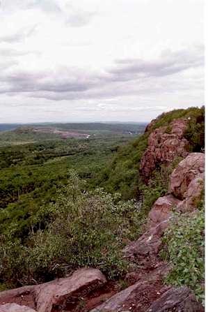
Higby Mountain or Mount Higby 892 feet (272 m), is a traprock mountain ridge located 3.75 miles (6.04 km) east of Meriden, Connecticut. It is part of the narrow, linear Metacomet Ridge that extends from Long Island Sound near New Haven, Connecticut, north through the Connecticut River Valley of Massachusetts to the Vermont border. Higby Mountain is known for its high cliff faces, unique microclimate ecosystems, and rare plant communities. It rises steeply 600 feet (180 m) above the Quinnipiac River valley and the city of Meriden to the west as a continuous 2-mile (3 km) long ledge. The mountain is traversed by the 50-mile (80 km) Mattabesett Trail.

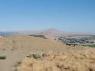
Badger Mountain is a small mountain in Richland, Washington. Badger rises above the Tri-Cities connected to the smaller Candy Mountain via Goose Gap, is visible throughout much of the area and is a popular hiking destination for a wide variety of climbers. There are a number of trails climbing the mountain with varying levels of difficulty. Most of Badger Mountain is protected by the Badger Mountain Centennial Preserve, but the radio towers at the peak are private property. There are two summits on Badger Mountain, named the East Summit and the West Summit. The West Summit is the highest.

Candy Mountain is a small mountain located just outside West Richland, Washington. Candy Mountain rises above the Tri-Cities, located between Badger Mountain to the south and Red Mountain to the north.

Goose Gap is the 19th American Viticultural Area (AVA) in Washington, United States. It encompasses the local region surrounding Goose Mountain in Benton County between Kiona to the west, and Richland along the Columbia River to the east. The viticultural area was formally established on August 2, 2021, by the Alcohol and Tobacco Tax and Trade Bureau (TTB), Treasury after reviewing the petition submitted by geologist/vintner, Alan Busacca, on behalf of the Goose Gap Wine Grower's Association, proposing the viticultural area "Goose Gap". The area is a sub-appellation entirely within the Yakima Valley and the expansive Columbia Valley AVAs sandwiched on a northwest–southeast axis between neighboring viticultural areas Red Mountain and the minute Candy Mountain.


