Gopalpeta

Last updated

Gopalpeta
Mandal
CountryFlag of India.svg  India
State Telangana
District Wanaparthy
Languages
  Official Telugu
Time zone UTC+5:30 (IST)
Vehicle registration TS 32
Climate hot (Köppen)

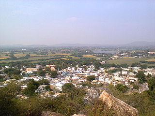
Gopalpeta is a Mandal in Wanaparthy district, Telangana, India. [1]

A tehsil is an administrative division in some countries of South Asia. It is an area of land with a city or town that serves as its administrative centre, with possible additional towns, and usually a number of villages. The terms in India have replaced earlier geographical terms, such as pargana, pergunnah and thannah, used under Delhi Sultanate and the British Raj.

Wanaparthy district District of Telangana in India

Wanaparthy district is a district in the Indian state of Telangana. It is located 143 km from the state capital Hyderabad. It is also an assembly Constituency in Telangana state. Wanaparthy is a famous historical site in Telangana and had served as capital of Wanaparthy Samsthanam. It was previously part of Mahabubnagar district.

Telangana State in Southern India

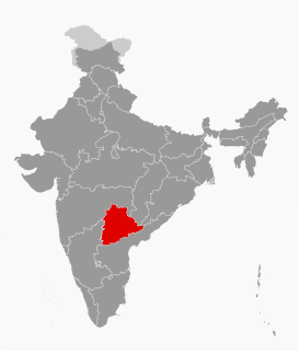
Telangana is a state in India situated on the centre-south stretch of the Indian peninsula on the high Deccan Plateau. It is the twelfth largest state and the twelfth-most populated state in India with a geographical area of 112,077 km2 (43,273 sq mi) and 35,193,978 residents as per 2011 census. On 2 June 2014, the area was separated from the northwestern part of Andhra Pradesh as the newly formed 29th state with Hyderabad as its historic permanent capital. Its other major cities include Warangal, Nizamabad, Khammam and Karimnagar. Telangana is bordered by the states of Maharashtra to the north, Chhattisgarh to the east, Karnataka to the west, and Andhra Pradesh to the east and south. The terrain of Telangana region consists mostly of hills, mountain ranges, and thick dense forests distribution of 27,292 sq. km. As of 2019, the state of Telangana is divided into 33 districts.

Contents

Institutions

Villages

The villages in Gopalpeta mandal include:

Buddaram village in Telangana, India

Buddaram is a village and Gram panchayat of Nalgonda mandal, Nalgonda district, in Telangana state.

Nagapur city in Maharashtra, India

Nagapur is a census town in Ahmadnagar district in the Indian state of Maharashtra.

Related Research Articles

Pebbair village in Telangana, India

Pebbair is a village and a Mandal in Wanaparthy district in the state of Telangana, India. The Pebbair Mandal extends from Pampuram village in the North to Yaparla village in the south..

Thalpunoor village in Telangana, India

Thalpunoor is a small village, located 12 km south west of Nagarkurnool, Revally Mandal and Wanaparthy district, India, situated in between 16.406 degrees northern longitude and 78.242° eastern latitude.

Bhoothpur village in Telangana State, India

Buthpur or Bhoothpur is a Mandal in Mahbubnagar district, Telangana.

Kodair in Telangana, India

Koder or Kodair is a village and mandal headquarters in Nagar Kurnool district, Telangana, India.

Kothakota Place in Telangana, India

Kothakota is a Municipality and mandal in Wanaparthy district, Telangana.

Ghanpur is a Mandal in Wanaparthy district, Telangana. It is also known as Khilla Ghanpur.It was a part of Mahbubnagar district earlier to the formation of new districts in Telangana.

Peddamandadi is a Mandal in Wanaparthy district, Telangana.

Tadoor is a Mandal in Nagarkurnool district, Telangana. Tadoor Mandal Headquarters is Tadoor village. It is located 54 km towards East from District headquarters Nagarkurnool. 113 km from State capital Hyderabad towards North.

The Bheema lift irrigation project or Rajiv Bheema Project is a lift irrigation canal project located in Mahbubnagar district in Telangana, India. Water is lifted at Panchdev Pahad from the back waters of Jurala Dam. Under the same project, another lift canal originates separately from the Ramanpahad balancing reservoir under Jurala left bank to irrigate the uplands.

Mahatma Gandhi Kalwakurthy lift irrigation project (KLIP) is a lift irrigation project on River Krishna located in Mahbubnagar district in Telangana, India. The lift canal starts from the back waters of Srisailam Dam near Kollapur. The gravity driven, 100 kilometer canal provides cultivation for nearly 4,00,000 acres in 300 villages located in constituencies of Kollapur, Wanaparthy, Nagarkurnool, Kalwakurthy, Jadcherla and Achampet.

Wanaparthy Assembly constituency

Nagarkurnool district District of Telangana in India

Nagarkurnool is a district in the southern region of the Indian state of Telangana. The town of Nagarkurnool is the district headquarters. It was part of the Mahbubnagar district prior to re-organisation of districts in the state.The district shares boundaries with Nalgonda, Rangareddy, Mahabubnagar, Wanaparthy districts and with Andhra pradesh State.

Veepanagandla is a mandal and village in Wanaparthy district, Telangana.

Pangal, Wanaparthy human settlement in India

Pangal is a mandal in Wanaparthy District of Telangana in India.

Atmakur, Wanaparthy Town in Telangana, Atmakur India

Atmakur is a town, municipality, and Mandal headquarters located in Wanaparthy district in the Telangana state of India.

Bekkem is a village in Chinnambaavi mandal in Wanaparthy district of Telangana.

Narayanapet District District of Telangana in India


Narayanapet district is a district in the Indian state of Telangana. Narayanapet is the district headquarters. The district shares boundaries with Mahbubnagar district, Vikarabad, Wanaparthy, Jogulamba Gadwal districts and with Karnataka state. This district formed on February 17, 2019 after bifurcation of Mahbubnagar district.

References

  1. "District Administration – Formation/Reorganization of District, Revenue Divisions and Mandals in Wanaparthy District – Final Notification - Orders – Issued" (PDF). Wanaparthy District. Retrieved 21 July 2017.