
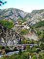
The Gorges de Daluis is a six-kilometer-long canyon formed by the river Var in the Alpes-Maritimes department in southeastern France. It runs south from Guillaumes to Daluis.
The Gorges de Daluis is a six-kilometer-long canyon formed by the river Var in the Alpes-Maritimes department in southeastern France. It runs south from Guillaumes to Daluis.
The canyon starts off at Guillaumes, running north to south, west of the Dôme de Barrot , and ends at the small commune of Daluis, where the Var widens. The 6-kilometer-long gorge [1] is cut in the red rock (sandstone colored by iron oxide, 260 million years old) [2] by the river Var. Notable views along the gorge (a touristic high point [2] and one of a number of "long, lonely canyons" in the area) [3] include the final waterfall of the Clue d'Amen. [4]

The area is dominated by the Dôme de Barrot, 2136 meters high, [2] dating from the Permian. [5] Former copper mining operations in the Dôme are still visible from the gorge, [6] [7] and unique mineral specimens have been found there. [8]
During the Beuil-Guillaumes insurrection of July–August 1944, the Pont de Berthéou was one of two bridges blown up by the French resistance in July 1944 (the Pont du Pra d'Astier on 7 July, the Pont de Berthéou the following day) in an attempt to halt German troops advancing toward Guillaumes. [9]

South from Guillaumes, the D902/D2202 runs on the west side of the gorge, with the southbound lane going through 17 tunnels. [10] The (now defunct) Alpes-Maritimes railroad line from Pont-de-Gueydan to Guillaumes, inaugurated in 1923, runs east from Guillaumes and crosses the gorge at the Pont de la Mariée, spanning 58 meters. Bungee jumping is done from the 80-meter-high bridge. [2] [10] Other notable sights include the Tête de la Femme, a rock formation resembling a woman's head on the west side of the road, just north of the Pont de Berthéou, [2] and the gorge is a popular destination for rafting [11] and canoeing. [12] The road along the gorge lends itself to motorcycle [13] and bicycle tourism. [14]


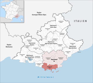
Var is a department in the Provence-Alpes-Côte d'Azur region of Southeastern France. It takes its name from the river Var, which flowed along its eastern boundary, until the boundary was moved in 1860. The Var department is bordered on the east by the department of Alpes-Maritimes, to the west by Bouches-du-Rhône, to the north of the river Verdon by the department of Alpes-de-Haute-Provence and to the south by the Mediterranean Sea.

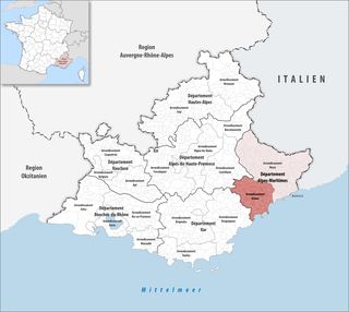
Alpes-Maritimes is a department of France located in the extreme southeast corner of the country, on the border with Italy and on the Mediterranean coast. Part of the Provence-Alpes-Côte d'Azur region, it had a population of 1,083,310 in 2017.
The Var is a river located in the southeast of France. It is 114 km (71 mi) long. Its drainage basin is 2,812 km2 (1,086 sq mi).

Provence-Alpes-Côte d'Azur is one of the eighteen administrative regions of France, the far southeastern on the mainland. Its prefecture and largest city is Marseille. The region is roughly coterminous with the former French province of Provence, with the addition of the following adjacent areas: the former papal territory of Avignon, known as Comtat Venaissin; the former Sardinian-Piedmontese County of Nice, whose coastline is known in English as the French Riviera and in French as the Côte d'Azur; and the southeastern part of the former French province of Dauphiné, in the French Alps. Previously known by the acronym PACA, the region adopted the name Région Sud as a commercial name or nickname in December 2017. 5,007,977 people live in the region according to the 2015 census.
Southern France, also known as the South of France or colloquially in French as le Midi, is a defined geographical area consisting of the regions of France that border the Atlantic Ocean south of the Marais Poitevin, Spain, the Mediterranean Sea, and Italy. It includes: southern Nouvelle-Aquitaine in the west, Occitanie in the centre, the southern parts of Auvergne-Rhône-Alpes in the northeast, Provence-Alpes-Côte d'Azur in the southeast, as well as the island of Corsica in the southeast.

The Verdon Gorge is a river canyon located in the Provence-Alpes-Côte d'Azur region of Southeastern France. It is about 25 km (15.5 mi) long and up to 700 metres (0.4 mi) deep. It was formed by the Verdon River, which is named for its turquoise-green colour, one of the location's distinguishing characteristics. In between the towns of Castellane and Moustiers-Sainte-Marie, the river has cut a ravine to a depth of 700 meters through the limestone mass. At the end of the canyon, the Verdon flows into the artificial Lake of Sainte-Croix.

Saint-Laurent-du-Var is a commune in the Alpes-Maritimes department in the Provence-Alpes-Côte d'Azur region on the French Riviera.
The arrondissement of Grasse is an arrondissement of France in the Alpes-Maritimes department in the Provence-Alpes-Côte d'Azur region. It has 62 communes. Its population is 561,067 (2016), and its area is 1,231.2 km2 (475.4 sq mi).

The arrondissement of Nice is an arrondissement of France in the Alpes-Maritimes department in the Provence-Alpes-Côte d'Azur region. It has 101 communes. Its population is 522,637 (2016), and its area is 3,067.4 km2 (1,184.3 sq mi).
The arrondissement of Toulon is an arrondissement of France in the Var department in the Provence-Alpes-Côte d'Azur region. It has 32 communes. Its population is 567,852 (2016), and its area is 1,233.5 km2 (476.3 sq mi).
This gallery of French coats of arms shows the coats of arms of the Provinces, Régions, and Départements of France, and of certain French cities. They are used to visually identify historical and present-day regions, as well as cities, within France.

Col de la Cayolle is a high mountain pass in the French Alps at the border between the departments of Alpes-Maritimes and Alpes-de-Haute-Provence in France.

Coaraze is a commune in the Alpes-Maritimes department in the Provence-Alpes-Côte d'Azur region in southeastern France.

Bairols is a commune in the Alpes-Maritimes department in the Provence-Alpes-Côte d'Azur region of south-eastern France.

Auvare is a commune in the Alpes-Maritimes department in the Provence-Alpes-Côte d'Azur region of south-eastern France.
Le Mas is a commune in the Alpes-Maritimes department in the Provence-Alpes-Côte d'Azur region of South-eastern France.

Montmeyan is a commune (municipality), located in the department of Var, in the region of Provence-Alpes-Côte d'Azur, southeastern France.

Métropole Nice Côte d'Azur is the métropole, an intercommunal structure, centred on the city of Nice. It is located in the Alpes-Maritimes department, in the Provence-Alpes-Côte d'Azur region, southeastern France. It was created in December 2011, replacing the previous Communauté urbaine Nice Côte d'Azur and the communautés de communes of les stations du Mercantour, La Tinée and Vésubie-Mercantour. In 2013 the commune Coaraze left the métropole, and in 2014 the communes Bonson, Le Broc, Gattières and Gilette joined it. Its population was 544,977 in 2014, of which 347,636 are located in Nice proper.

Pont de l'Artuby, also called Pont sur l'Artuby or Pont de Chaulière, is a two-lane road bridge that connects Route D 71 to the Artuby Gorge in the Var department in the French region of Provence-Alpes-Côte d'Azur. The nearest towns are Aiguines and Trigance, which are 22 and 13 km away respectively.