Fukushima is the capital city of Fukushima Prefecture, Japan. It is located in the northern part of the Nakadōri, central region of the prefecture. As of 1 August 2023, the city had an estimated population of 275,850 in 122,130 households and a population density of 359 inhabitants per square kilometre (930/sq mi). The total area of the city is 767.72 square kilometres (296.42 sq mi).

Yamagata Prefecture is a prefecture of Japan located in the Tōhoku region of Honshu. Yamagata Prefecture has a population of 1,028,055 and has a geographic area of 9,325 km2. Yamagata Prefecture borders Akita Prefecture to the north, Miyagi Prefecture to the east, Fukushima Prefecture to the south, and Niigata Prefecture to the southwest.

Fukushima Prefecture is a prefecture of Japan located in the Tōhoku region of Honshu. Fukushima Prefecture has a population of 1,771,100 and has a geographic area of 13,783.90 square kilometres (5,321.99 sq mi). Fukushima Prefecture borders Miyagi Prefecture and Yamagata Prefecture to the north, Niigata Prefecture to the west, Gunma Prefecture to the southwest, and Tochigi Prefecture and Ibaraki Prefecture to the south.

Kitashiobara is a village located in Fukushima Prefecture, Japan. As of 1 April 2020, the village had an estimated population of 2,697 in 1091 households, and a population density of 12 persons per km2. The total area of the village was 234.08 square kilometres (90.38 sq mi).

Bandai is a town located in Fukushima Prefecture, Japan. As of 1 March 2018, the town had an estimated population of 3,533 in 1195 households, and a population density of 60.3 persons per km2. The total area of the town was 59.77 square kilometres (23.08 sq mi).

Inawashiro is a town located in Fukushima Prefecture, Japan. As of 1 March 2020, the town had an estimated population of 13,810 in 5309 households, and a population density of 35 persons per km2. The total area of the town was 394.85 square kilometres (152.45 sq mi). It is noted as the birthplace of the famous doctor Hideyo Noguchi, who contributed to knowledge in the fight against syphilis and yellow fever.

The Zaō Mountains, commonly called Mount Zaō, are a complex cluster of stratovolcanoes on the border between Yamagata Prefecture and Miyagi Prefecture in Japan. The central volcano of the group includes several lava domes and a tuff cone, Goshiki-dake, which contains a crater lake named "Okama". Also known as the "Five Color Pond" because it changes color depending on the weather, it lies in a crater formed by a volcanic eruption in the 1720s. The lake is 360 metres (1,200 ft) in diameter and 60 m (200 ft) deep, and is one of the main tourist attractions in the area.

Mount Nekomadake is a stratovolcano located west of Mount Bandai, close to Bandai town and Kitashiobara village in the Fukushima Prefecture, Japan. It is 1,403.6 metres high, and close to Lake Inawashiro and Oguni-numa Pond. Nekoma volcano is thought to be 0.8 - 1 million years old.

Mount Nikkō-Shirane is a stratovolcano in the Nikkō National Park in central Honshū, the main island of Japan. It stands at 2,578 m high. It is the highest mountain in north eastern Japan. Its peak is a Lava dome of andesite. Mt Nikkō-Shirane is listed in the 100 famous mountains in Japan proposed by Kyuya Fukada and also of one of the famous mountains of Tochigi and Gunma prefectures respectively.
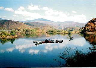
Lake Inawashiro is the fourth-largest lake in Japan, located in central Fukushima Prefecture, south of Mount Bandai. It is also known as the 'Heavenly Mirror Lake'. The lake is located within the borders of Bandai-Asahi National Park. It is a surface area of 104 square kilometres (40 sq mi), circumference of 63 kilometres (39 mi), depth of 94 metres (308 ft) and is located at an altitude of 514 metres (1,686 ft). In winter swans migrate to the beaches of the lake and stay there until spring.

Mount Bandai is a stratovolcano located in Inawashiro-town, Bandai-town, and Kitashiobara village, in Yama-Gun, Fukushima prefecture. It is an active stratovolcano located to the north of Lake Inawashiro. Mount Bandai, including the Bandai heights, belongs to the Bandai-Asahi National Park.

Mount Adatara is a stratovolcano in Fukushima Prefecture, Japan.

Mount Azuma-kofuji (吾妻小富士) is an active stratovolcano in Fukushima prefecture, Japan.

Lake Hibara is a lake located in Yama District, Fukushima, Japan. It is a part of the Bandai-Asahi National Park and is the largest of the lakes in the Bandai Highland.

The 1888 eruption of Mount Bandai was a major volcanic eruption which occurred during the Meiji period of the Empire of Japan. The eruption occurred on July 15, 1888, pyroclastic flows buried villages on the northern foot of the mountain, and devastated the eastern part of Bandai region, Iwashiro Province north of Tokyo. At least 477 people were killed, and hundreds more were injured and rendered homeless.
Akimoto Lake (秋元湖) is located in Fukushima Prefecture, Japan. Straddling the border between the village of Kitashiobara and the town of Inawashiro, it serves as a reservoir, supplying drinking water to local residents. Along with Hibara Lake and Onogawa Lake, it constitutes the "Inner Bandai Plateau Tri-Lake Formation" of the Bandai Highland.

Morohashi Museum of Modern Art opened in Kitashiobara, Fukushima Prefecture, Japan, in 1999. It is situated within Bandai-Asahi National Park, near Goshiki-numa and with views of Mount Bandai. The permanent collection includes over three hundred forty pieces by Salvador Dalí which makes it the fourth largest Dalí Museum in the world and the sole Dalí Museum in Asia, as well as works by Sisley, Cézanne, Renoir, Matisse and Picasso.

Okama, meaning an honourable cauldron, is the inactive volcanic crater on top of Mount Zaō, located in Kawasaki, Miyagi, on the border with Yamagata, Japan. While local people call it affectionately Okama, the visitors tend to call it Goshiki-numa, meaning "Five Color Pond", because its color changes depending on the time of the day, the weather, or the season of the year.

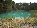
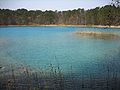
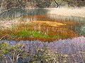
The Bandai Highland, also called Urabandai (裏磐梯), is the plateau on the north side of Mount Bandai, at the elevation of 800 meters above sea lavel, in West Fukushima, Japan. It is surrounded on the other sides by Mount Adatara and Mount Azuma, and is part of Bandai-Asahi National Park.

Lake Onogawa, is a lake located in Kitashiobara, Fukushima, Japan. It is one of the three larger lakes in the Bandai Highland, the other two being Lake Hibara in its west and Lake Akimoto in its east.