
Charleroi is a city and a municipality of Wallonia, located in the province of Hainaut, Belgium. The city is situated in the valley of the Sambre, in the south-west of Belgium, not far from the border with France. By 1 January 2008, the total population of Charleroi was 201,593. The metropolitan area, including the outer commuter zone, covers an area of 1,462 square kilometres (564 sq mi) with a total population of 522,522 by 1 January 2008, ranking it as the 5th most populous in Belgium after Brussels, Antwerp, Liège, and Ghent. The inhabitants are called Carolorégiens or simply Carolos.

Couvin is a city and municipality of Wallonia located in the province of Namur, Belgium.

Saint-Gilles or Sint-Gillis is one of the 19 municipalities of the Brussels-Capital Region, Belgium. Located in the southern part of the region, it is bordered by the City of Brussels, Anderlecht, Forest and Ixelles. In common with all of Brussels' municipalities, it is legally bilingual (French–Dutch), but predominantly French-speaking nowadays.

Brussels South Charleroi Airport (BSCA), also informally called Brussels-Charleroi Airport or Charleroi Airport, is an international airport located in Gosselies, a part of the city of Charleroi, Belgium. The airport is 4 nautical miles north of Charleroi and 46 km south of central Brussels.

Brussels-South railway station is a major railway station in Brussels, Belgium. Geographically, it is located in Saint-Gilles/Sint-Gillis on the border with the adjacent municipality of Anderlecht and just south of the City of Brussels.
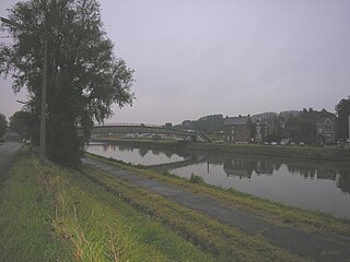
Luttre is a village of Wallonia and a district of the municipality of Pont-à-Celles, located in the province of Hainaut, Belgium, about 15 km north of Charleroi and 50 km south of Brussels along the Charleroi-Brussels Canal, railway line and motorway. Its name means crystal clear water.
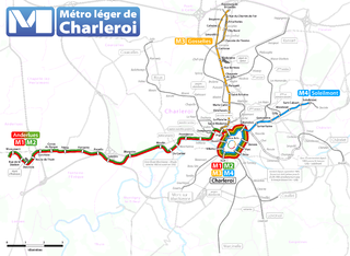
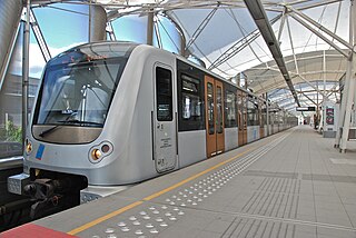
The Métro Léger de Charleroi is a 33-kilometre (21 mi) light rail network in Belgium. The system consists of a loop line around central Charleroi and three branches towards the suburbs of Gilly, Anderlues and Gosselies. Another branch to Châtelet was partially built, never entered service, but will finally do so in 2026.

Brussels-North railway station is one of the three major railway stations in Brussels, Belgium; the other two are Brussels-Central and Brussels-South. Every regular domestic and international train passing there has a planned stop. The station has 200,000 passengers per week, mainly commuters, making it one of the busiest in Belgium.
Brussels has an extensive network of both private or public transportation means. Public transportation includes Brussels buses, trams, and metro, as well as a set of railway lines and railway stations served by public trains. Air transport is available via one of the city's two airports, and boat transport is available via the Port of Brussels. Bicycle-sharing and car-sharing public systems are also available. The city is relatively car-dependent by northern European standards and is considered to be the most congested city in the world according to the INRIX traffic survey.

Charleroi-Central railway station is the main railway station serving Charleroi, Hainaut, Belgium. It is operated by the National Railway Company of Belgium (SNCB/NMBS). It was formerly called Charleroi-South railway station until December 2022.

Charleroi-West railway station is a secondary railway station serving Charleroi, Hainaut, Belgium. It is one of two railway stations located in downtown Charleroi, the other one being the much larger Charleroi-Central railway station. It is operated by the National Railway Company of Belgium (SNCB/NMBS).

Piges is a Charleroi Metro station, located in Dampremy, in fare zone 1. The station is built on a viaduct and is accessed through escalators and stairs from a street entrance located on Chaussée de Bruxelles.

Sart-Culpart is a Charleroi Metro station located in Gilly, Belgium, opened on 27 February 2012 as part of the Soleilmont extension of the Gilly branch of the Charleroi Pre-metro. The station is built at ground level and features a two lateral platforms.

Line M3 is a line of the Charleroi Metro in Belgium operated by TEC Charleroi, running from Gosselies to the loop around downtown Charleroi, before heading back to Gosselies.

The Battle of Gosselies or Battle of Charleroi saw a Republican French army co-commanded by Jacques Desjardin and Louis Charbonnier try to cross the Sambre River against a joint Dutch and Habsburg Austrian army under William, Hereditary Prince of Orange. The French defeat in the battle marked the third of five attempts by their armies to win a foothold on the north bank of the Sambre during the War of the First Coalition. In 1794, Gosselies was a separate village but is now part of the Charleroi municipality, about 7 kilometres (4 mi) north of the city center. Charleroi is located about 60 kilometres (37 mi) south of Brussels.

The Battle of Lambusart saw a Republican French army led by Jean Baptiste Jourdan try to cross the Sambre River against a combined Dutch and Habsburg Austrian army under William VI, Hereditary Prince of Orange. This battle was the culmination of the fourth of five attempts to consolidate a foothold on the north side of the Sambre. The clash occurred during the War of the First Coalition, part of a wider struggle known as the Wars of the French Revolution. In 1794, Lambusart was an independent village, but it is now part of the Fleurus municipality. Lambusart is located about 10 kilometres (6 mi) northeast of Charleroi.

Nivelles railway station is a railway station in Nivelles, Walloon Brabant, Belgium. The station opened on 1 June 1874 and is located on railway line 124. The train services are operated by the National Railway Company of Belgium (SNCB/NMBS).
Prostitution is legal in Belgium, but related activities such as organising prostitution and other forms of pimping are illegal. Enforcement varies, and in some areas brothels are unofficially tolerated.

UCLouvain Charleroi is a campus of the University of Louvain in Charleroi, Belgium. Consisting of 3 faculties and a series of research centers and institutes, UCLouvain Charleroi consists of the Maison Georges Lemaître, in the center of the city, and a branch in Montignies-sur-Sambre.


