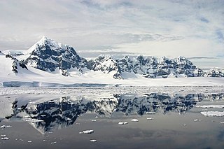
Wiencke Island is an island 26 km (16 mi) long and from 3 to 8 km wide, about 67 km2 (26 sq mi) in area, the southernmost of the major islands of the Palmer Archipelago, lying between Anvers Island to its north across the Neumayer Channel and the west coast of the Antarctic Peninsula to its east across the Gerlache Strait.

Port Lockroy is a bay forming a natural harbour on the north-western shore of Wiencke Island in the Palmer Archipelago to the west of the Antarctic Peninsula. The Antarctic base with the same name, situated on Goudier Island in this bay, includes the most southerly operational post office in the world. The base was left unstaffed from 2020 to 2022 due to the COVID-19 pandemic, though the museum house remained open to individual visits. On 4 October 2022 it was announced that a team of four women had been chosen to return to open the base for the summer 2022/23 season.

Ulu Peninsula is that portion of James Ross Island northwest of the narrow neck of land between Rohss Bay and Croft Bay, extending from Cape Obelisk to Cape Lachman, in Antarctica.
Jabet Peak is a peak in the Comer Range, 545 metres (1,790 ft) high, which marks the southwestern end of the serrate ridge 1 mile (1.6 km) northeast of Port Lockroy, Wiencke Island, in the Palmer Archipelago, Antarctica. It was probably first sighted in 1898 by the Belgian Antarctic Expedition under Gerlache, and was first charted by the French Antarctic Expedition, 1903–05, under Jean-Baptiste Charcot, who named it for Jacques Jabet, boatswain of the expedition ship Français.

Posadowsky Glacier is a glacier about 9 nautical miles long, flowing north to Posadowsky Bay immediately east of Gaussberg. Posadowsky Bay is an open embayment, located just east of the West Ice Shelf and fronting on the Davis Sea in Kaiser Wilhelm II Land. Kaiser Wilhelm II Land is the part of East Antarctica lying between Cape Penck, at 87°43'E, and Cape Filchner, at 91°54'E, and is claimed by Australia as part of the Australian Antarctic Territory. Other notable geographic features in this area include Drygalski Island, located 45 mi NNE of Cape Filchner in the Davis Sea, and Mirny Station, a Russian scientific research station.
Alice Creek is a cove forming the southernmost portion of Port Lockroy, Wiencke Island, in the Palmer Archipelago of Antarctica. It was discovered by the French Antarctic Expedition, 1903–05, under Jean-Baptiste Charcot, and named by him for the wife of Édouard Lockroy, Vice President of the French Chamber of Deputies who assisted Charcot in obtaining government support for the expedition.
Besnard Point is a headland which lies at the southeast side of Port Lockroy, Wiencke Island, and marks the east side of the entrance to Alice Creek, in the Palmer Archipelago. It was discovered by the French Antarctic Expedition, 1903–05, under Jean-Baptiste Charcot, and named by him for A. Besnard, seaman on the expedition ship Français.
Bills Island is an island in Antarctica. It lies northeast of Goudier Island in the harbor of Port Lockroy, in the Palmer Archipelago. It was discovered and charted by the French Antarctic Expedition, 1903–05, under Jean-Baptiste Charcot. The name appears on a chart based on a 1927 Discovery Investigations survey, but may reflect an earlier naming.
Butler Passage is a passage between the Wauwermans Islands and the Puzzle Islands, connecting Peltier Channel and Lemaire Channel, off the west coast of Graham Land. The route was probably first used by the French Antarctic Expedition under Jean-Baptiste Charcot, 1903–05 and 1908–10, on their trips between Port Lockroy and Booth Island. It was named by the UK Antarctic Place-Names Committee in 1959 for Captain Adrian R.L. Butler, Royal Navy, captain of the British naval guardship HMS Protector which was in this area in 1957–58 and 1958–59.

Jougla Point is a point forming the west side of the entrance to Alice Creek in Port Lockroy, lying on the west side of Wiencke Island, in the Palmer Archipelago, Antarctica. It was discovered and named by the French Antarctic Expedition, 1903–05, under Jean-Baptiste Charcot, who considered it to be a peninsula. Because of its small size the term point is considered more appropriate.

Peltier Channel is a channel 6 nautical miles (11 km) long, in a NE-SW direction, separating Doumer and Wiencke Island Islands to the south of Port Lockroy, in the Palmer Archipelago to the west of the Antarctic Peninsula. Discovered by the French Antarctic Expedition, 1903–05, and named by Charcot for Jean Peltier, noted French physicist.
Flag Point is a point which lies 0.3 nautical miles (0.6 km) east-southeast of Damoy Point and forms the north side of the entrance to Port Lockroy, Wiencke Island, in the Palmer Archipelago. It was discovered by the French Antarctic Expedition, 1903–05, under Jean-Baptiste Charcot. It was named by the Falkland Islands Dependencies Survey (FIDS) in 1944; when the FIDS base at Port Lockroy was established in 1944, a metal Union Flag was erected on this point.

Hamburg Bay is a bay indenting the northwest coast of Anvers Island in the Palmer Archipelago, Antarctica immediately south of Bonnier Point, Obitel Peninsula. Emen Island and Petrelik Island are located in the southwest part of the bay.
Harbour Glacier is a through glacier 3 nautical miles (6 km) long and 1.5 nautical miles (3 km) wide, lying on the northwest side of Wiencke Island and extending in a northeast direction from Port Lockroy to the cove 1 nautical mile (2 km) east of Noble Peak, in the Palmer Archipelago, Antarctica. It was probably first seen by the Belgian Antarctic Expedition, 1897–99, under Gerlache. The glacier was charted in 1944 by the Falkland Islands Dependencies Survey, who so named it because of its proximity to the harbour of Port Lockroy.
Lockley Point is a low, ice-covered point lying 1 nautical mile (2 km) northeast of Noble Peak on the northwest side of Wiencke Island, in the Palmer Archipelago, Antarctica. It was discovered by the Belgian Antarctic Expedition under Gerlache in 1898. The point was resighted and charted by the Falkland Islands Dependencies Survey in 1944, and named for Lieutenant J.G. Lockley, Royal Naval Volunteer Reserve, base leader, biologist, and meteorologist at Port Lockroy in 1945.
Marr Ice Piedmont is a large ice piedmont which covers the northwestern half of Anvers Island, in the Palmer Archipelago, Antarctica. This feature was presumably first seen by a German expedition under Eduard Dallmann, 1873–74, and was first roughly surveyed by the French Antarctic Expedition, 1903–05, and French Antarctic Expedition, 1908–10, both under Jean-Baptiste Charcot. It was named by the UK Antarctic Place-Names Committee for British marine biologist James W.S. Marr, first commander of the Falkland Islands Dependencies Survey, 1943–45, and leader of the base at nearby Port Lockroy. Marr was also a member of the British Australian New Zealand Antarctic Research Expedition under Mawson, 1929–31, and of Shackleton's expedition of 1921–22.
Sinker Rock is a rock off the north tip of Goudier Island, near the center of the harbor of Port Lockroy, in the Palmer Archipelago. Rocks were charted in this position by the French Antarctic Expedition, 1903–05, under Charcot. So named by the Falkland Islands Dependencies Survey (FIDS) in 1944 because a sinker was laid near this rock for a boat mooring.
Smith Point is a small point northeast of Besnard Point on the southeast side of the harbor of Port Lockroy, Wiencke Island, in the Palmer Archipelago. Discovered by the French Antarctic Expedition, 1903–05, under Charcot. The name appears on a chart based upon a 1927 survey by DI personnel on the Discovery, but may reflect an earlier naming.
Homeward Point is a point forming the west side of the entrance to Security Bay, on Doumer Island in the Palmer Archipelago, Antarctica. It was first charted by the French Antarctic Expedition, 1903–05, under Jean-Baptiste Charcot, and so named by the British Naval Hydrographic Survey Unit in 1956–57 because the point was sighted as a prominent landmark almost daily by the crew of their motor-launch when homeward bound for Port Lockroy at the end of a day's survey work in the Bismarck Strait.
Lécuyer Point is a point which forms the south side of the entrance to the harbor of Port Lockroy, Wiencke Island, in the Palmer Archipelago, Antarctica. It was discovered and named by the French Antarctic Expedition, 1903–05, under Jean-Baptiste Charcot.

