Muzaffarpur District is one of the thirty-eight districts of Bihar state, India. Muzaffarpur district is a part of Tirhut Division (Tirhut).

Hussainpur is a census town in Jalandhar district in the Indian state of Punjab. It is situated in Jalandhar II Tehsil. The village code is 030405.

Nallabelly is a village and a mandal in Warangal (rural) district in the state of Telangana in India.
Kannamangala village is located in Bangalore East Tehsil of Bangalore district in Karnataka, India. It is situated 6 km away from sub-district headquarter Bangalore East. As per 2009 stats, Kannamangala village is also a gram panchayat.

Dhanushadham is a municipality in Danusha District in the Janakpur Zone of south-eastern Nepal. The municipality was established on 18 May 2014 by merging the existing Govindapur, Umprempur, Yagyabhumi, Dhanushadham village development committees (VDCs). It is a religious place of Hindu worship in Nepal. It is believed that a part of Shiva Dhanusha that was broken by Rama during Sita's swayamvara, is housed. Now there is temple around the remaining of bow and visited by Hindu devotees from all over the world. That's why it is named Dhanushadham.

The Eastern Development Region was one of Nepal's five development regions. It is also known as Kirata region. It was located at the eastern end of the country with its headquarters at Dhankuta. The town of Dhankuta was the headquarter of the Eastern Region, as well as the headquarter of the Dhankuta District.

Honnihalli is a village in Belagavi district in the southern state of Karnataka, India.
Karambal is a village in Belgaum district in Karnataka, India. Karambal village is located in Khanapur Tehsil of Belgaum district in Karnataka, India. It is situated 3km away from sub-district headquarter Khanapur and 28km away from district headquarter Belgaum. As per 2009 stats, Karmbla is the gram panchayat of Karambal village. The total geographical area of village is 387.3 hectares. Karambal has a total population of 1,400 peoples. There are about 294 houses in Karambal village. Khanapur is nearest town to Karambal which is approximately 3km away.
Kolavi is a village in Gokak taluka and Belagavi district in Karnataka, India.It is located around 12 km from Gokak and 54 km from district headquarter Belagavi.The common language in use is Kannada. The main occupation of the people here is agriculture.
Shirapur is a village in Parner taluka in Ahmednagar district of state of Maharashtra, India.

Mania is a village in Dildarnagar Kamsar in the Indian state of Uttar Pradesh. Mania village is located in Zamania Tehsil of Ghazipur district in Uttar Pradesh, India. It is situated 22km away from sub-district headquarter Zamania and 31km away from district headquarter Ghazipur. The total geographical area of village is 231.85 hectares. Mania has a total population of 5,406 peoples. There are about 717 houses in Mania village. Dildar Nagar is nearest town to Mania which is approximately 9km away.
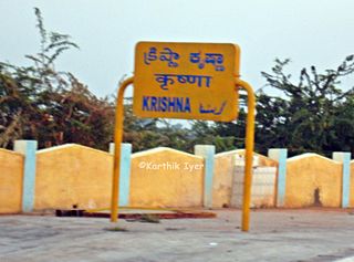
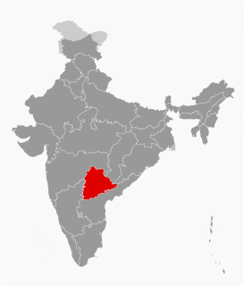
Krishna Railway Station is located in Telangana, Mahbubnagar, Maganoor. It belongs to South Central Railway zone, Guntakal railway division of Indian Railways. Neighbourhood stations are Chegunta, Saidapur, Yadlapur. Nearby major railway station is Secunderabad Junction another nearby major railway station is Raichur and airport is Rajiv Gandhi International Airport. A total of 16 express trains stop at this station. It is an important station for people in rural areas of neighbouring small villages such as Chegunta, Yadlapur. A lot of native Telugu people of this area are migrated to neighbouring Maharashtra they visit their native villages occasionally.
Jajo Mazara or Jajo Majara is a small size village with the population of only 13 people in Phillaur tehsil of Jalandhar District of Punjab State, India. It is located 11 km away from Goraya, 22.8 km from Phillaur, 30.5 km from district headquarter Jalandhar and 122 km from state capital Chandigarh. The village is administrated by a sarpanch who is an elected representative of village as per Panchayati raj (India).
Bainapur is a small size village in Phillaur tehsil of Jalandhar district of Punjab State, India. It is located 25 km away from Phillaur, 5.8 km from Nurmahal, 27.7 km from district headquarter Jalandhar and 147 km from state capital Chandigarh. The village is administrated by a sarpanch who is an elected representative of village as per Panchayati raj (India).
Lakhapadar is a village and former non-salute princely state on Saurashtra peninsula in Gujarat, western India. About Lakhapadar
Partapur is a village in Bidar district of the state of Karnataka, India. According to 2011 Census information, the location code or village code of Partapur is 599747. Partapur is located in Basavakalyan Tehsil of Bidar district in Karnataka, India. It is situated 3km away from sub-district headquarter Basavakalyan and 85km away from district headquarter Bidar. As per 2009 stats, Partapur village is also a gram panchayat.
Pilode is a village is located in Amalner Tehsil of Jalgaon district in Maharashtra, India. It is situated 10 km away from sub-district headquarter Amalner and 65 km away from district headquarter Jalgaon.
Kalpalayam is a village located in the Manachanallur taluk of the Tiruchirappalli district of the Indian state Tamil Nadu. It is situated 3 km away from taluk headquarter Manachanallur and 15 km away from district headquarter Tiruchirappalli.
Manjari is a village located in Chikodi Tehsil of Belgaum district in Karnataka, India. It is located 20km away from sub-district headquarter Chikodi and 100km away from district headquarter Belgaum. As per 2009 stats, Manjari village is also a gram panchayat. The total geographical area of village is 555.71 hectares. Manjari has a total population of 8,613 peoples. There are about 1,844 houses in Manjari village. Chikodi is nearest town to Manjari which is approximately 20km away.