Kępy is a village in the administrative district of Gmina Wądroże Wielkie, within Jawor County, Lower Silesian Voivodeship, in south-western Poland. Prior to 1945 it was in Germany.

Niedźwiedzice is a village in the administrative district of Gmina Walim, within Wałbrzych County, Lower Silesian Voivodeship, in south-western Poland. Prior to 1945 it was in Germany. It lies approximately 7 kilometres (4 mi) north-west of Walim, 9 km (6 mi) south-east of Wałbrzych, and 63 km (39 mi) south-west of the regional capital Wrocław.
Sośno is a village in Sępólno County, Kuyavian-Pomeranian Voivodeship, in north-central Poland. It is the seat of the gmina called Gmina Sośno. It lies approximately 13 kilometres (8 mi) south-east of Sępólno Krajeńskie and 37 km (23 mi) north-west of Bydgoszcz.
Wojtówce is a village in the administrative district of Gmina Knyszyn, within Mońki County, Podlaskie Voivodeship, in north-eastern Poland.
Wilcza Jama is a village in the administrative district of Gmina Sokółka, within Sokółka County, Podlaskie Voivodeship, in north-eastern Poland, close to the border with Belarus.

Kwasówka is a settlement in the administrative district of Gmina Janów, within Sokółka County, Podlaskie Voivodeship, in north-eastern Poland. It lies approximately 9 kilometres (6 mi) south of Janów, 18 km (11 mi) west of Sokółka, and 31 km (19 mi) north of the regional capital Białystok.
Oprzężów-Kolonia is a village in the administrative district of Gmina Wola Krzysztoporska, within Piotrków County, Łódź Voivodeship, in central Poland.
Broszki-Kolonia is a village in the administrative district of Gmina Złoczew, within Sieradz County, Łódź Voivodeship, in central Poland. It lies approximately 5 kilometres (3 mi) south-east of Złoczew, 25 km (16 mi) south of Sieradz, and 72 km (45 mi) south-west of the regional capital Łódź.
Grądy is a village in the administrative district of Gmina Galewice, within Wieruszów County, Łódź Voivodeship, in central Poland. It lies approximately 6 kilometres (4 mi) north-west of Galewice, 11 km (7 mi) north-east of Wieruszów, and 98 km (61 mi) south-west of the regional capital Łódź.
Niemojew is a village in the administrative district of Gmina Lututów, within Wieruszów County, Łódź Voivodeship, in central Poland. It lies approximately 3 kilometres (2 mi) north-east of Lututów, 24 km (15 mi) north-east of Wieruszów, and 83 km (52 mi) south-west of the regional capital Łódź.
Nowosiółki Kardynalskie is a village in the administrative district of Gmina Lubycza Królewska, within Tomaszów Lubelski County, Lublin Voivodeship, in eastern Poland, close to the border with Ukraine. It lies approximately 18 kilometres (11 mi) south-east of Tomaszów Lubelski and 122 km (76 mi) south-east of the regional capital Lublin. The village is located in the historical region Galicia.
Szarkówka is a village in the administrative district of Gmina Charsznica, within Miechów County, Lesser Poland Voivodeship, in southern Poland. It lies approximately 3 kilometres (2 mi) south-west of Charsznica, 9 km (6 mi) north-west of Miechów, and 37 km (23 mi) north of the regional capital Kraków.
Mokra is a village in the administrative district of Gmina Stąporków, within Końskie County, Świętokrzyskie Voivodeship, in south-central Poland. It lies approximately 5 kilometres (3 mi) south of Stąporków, 15 km (9 mi) south-east of Końskie, and 26 km (16 mi) north of the regional capital Kielce.
Cząstków Polski is a village in the administrative district of Gmina Czosnów, within Nowy Dwór Mazowiecki County, Masovian Voivodeship, in east-central Poland.
Skały is a village in the administrative district of Gmina Toszek, within Gliwice County, Silesian Voivodeship, in southern Poland. It lies approximately 10 kilometres (6 mi) west of Toszek, 30 km (19 mi) north-west of Gliwice, and 51 km (32 mi) north-west of the regional capital Katowice.
Suche Łany is a village in the administrative district of Gmina Strzelce Opolskie, within Strzelce County, Opole Voivodeship, in south-western Poland.
Przodkowo-Wybudowanie is a village in the administrative district of Gmina Przodkowo, within Kartuzy County, Pomeranian Voivodeship, in northern Poland. It lies approximately 2 kilometres (1 mi) north of Przodkowo, 9 km (6 mi) north-east of Kartuzy, and 23 km (14 mi) west of the regional capital Gdańsk.
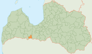
Tērvete Municipality is a municipality in Zemgale, Latvia. The municipality was formed in 2002 by merging Augstkalne parish, Bukaiši parish and Tērvete parish, the administrative centre being Zelmeņi.
The Aschberg is a mountain on border of Saxony, southeastern Germany and Bohemia, the Czech Republic. The summit lies in Czech side.
The Atlanta Hotel also known as Thompson's Hotel, was one of the original hotels in antebellum Atlanta, Georgia. It stood at the northwest side of State Square, pre-war Atlanta's central square, on the northwest side of Pryor Street between Decatur Street and what is now Wall Street.


