Grafton Bridge, New South Wales

Last updated

Grafton Bridge

Graftonbridge1.jpg

View of Grafton Bridge from the north bank of the Clarence River, August 2005
Coordinates 29°41′52.6″S152°56′31.5″E / 29.697944°S 152.942083°E / -29.697944; 152.942083 Coordinates: 29°41′52.6″S152°56′31.5″E / 29.697944°S 152.942083°E / -29.697944; 152.942083
Carries Motor vehicles, railway line, water supply, pedestrians
Crosses Clarence River
Locale Grafton, New South Wales, Australia
Maintained by Roads and Maritime Services, NSW Government
Characteristics
Design Bascule bridge
Material Steel
Piers in water 7 concrete [1]
Clearance above 38 feet (12 m) [1]
Clearance below 11 feet (3.4 m) [1]
History
Constructed by NSW Public Works (project manager); [1]
Dorman Long (main contractor) [2]
Construction start 1922 (1922)
Construction end 1932 (1932)
Construction cost £500,000 [1]
Inaugurated 19 July 1932 (1932-07-19) [1]

Grafton Bridge is a bascule bridge which spans the Clarence River in Grafton, New South Wales, Australia. It links the main townsite with South Grafton, and carries the North Coast railway line (part of the Sydney–Brisbane rail corridor).

Bascule bridge moveable bridge using a counterweight to balance a span through its upward swing to let boats move underneath

A bascule bridge is a moveable bridge with a counterweight that continuously balances a span, or "leaf", throughout its upward swing to provide clearance for boat traffic. It may be single- or double-leafed.

Clarence River (New South Wales) river in the Northern Rivers district of New South Wales, Australia

The Clarence River, a mature wave dominated, barrier estuary, is situated in the Northern Rivers district of New South Wales, Australia.

Grafton, New South Wales City in New South Wales, Australia

Grafton is a city in the Northern Rivers region of the Australian state of New South Wales. It is located on the Clarence River, approximately 500 kilometres (310 mi) north-northeast of the state capital Sydney. The closest major cities, Brisbane and the Gold Coast, are located across the border in South-East Queensland. According to the 2016 census, the Grafton "significant urban area" had a population of 18,668 people. The city is the largest settlement and administrative centre of the Clarence Valley Council local government area, which has over 50,000 people in all.

Contents

Design and features

Grafton Bridge over the Clarence River showing Bascule span lifted to let shipping through. (Postcard from about 1932; The Southern Cross aeroplane has been added to the photograph). GraftonBasculeBridgeSpanLiftingCirca1932.jpg
Grafton Bridge over the Clarence River showing Bascule span lifted to let shipping through. (Postcard from about 1932; The Southern Cross aeroplane has been added to the photograph).

The upper level of the bridge supports a two way road for traffic via Bent Street (Summerland Way), and its lower level supports a rail bridge that carries the North Coast railway line, a water main, and footbridges on either side.

The Summerland Way is a 199–kilometre state route, designated B91, in New South Wales. It runs generally north from Grafton to the border between NSW and Queensland just west of Mount Lindesay. The road continues from there into Queensland as Mount Lindesay Highway. With the decommissioning of the Mount Lindesay Highway in New South Wales in 1982, the length of the Summerland Way was increased by 9.4 km to the Queensland border. It is sealed for its entire length, although some of the road north of the Lions Road turn-off is narrow and winding. In 1996, the Federal Government committed $20 million toward upgrading the Summerland Way. A $7 million contract to realign 1.2 km at Dourrigan's Gap, approximately 16 km north of Kyogle, was awarded, with work starting in February 2002 and expected to take 12 months to complete.

North Coast railway line, New South Wales railway line in New South Wales, Australia

The North Coast Line is the primary rail route in the Mid North Coast and Northern Rivers regions of New South Wales, Australia, and forms a major part of the Sydney–Brisbane rail corridor.

A bridge over the Clarence River in Grafton was first conceived in 1915. The original design called for a railway bridge with a footway, but in 1922 the design was changed to accommodate vehicular traffic as well. There is provision for a second track across the bridge but at this time it is being used as an easement for a water main. The Grafton Bridge was built by Dorman Long [2] and opened in 1932 by the Governor-General of Australia, Sir Isaac Isaacs. [1] [3]

Dorman Long is an engineering consultancy and equipment manufacturer for the construction of long-span bridges, power stations, refineries, offshore structures, stadia and other large building structures. Originally based in Middlesbrough, North East England, the company was a major steel producer later diversifying into bridge building. Dorman Long was once listed on the London Stock Exchange.

Governor-General of Australia representative of the monarch of Australia

The Governor-General of the Commonwealth of Australia is the representative of the Australian monarch, currently Queen Elizabeth II. As the Queen is shared equally with the 15 other Commonwealth realms, and resides in the United Kingdom, she, on the advice of her prime minister, appoints a governor-general to carry out constitutional duties within the Commonwealth of Australia. The governor-general has formal presidency over the Federal Executive Council and is commander-in-chief of the Australian Defence Force. The functions of the governor-general include appointing ministers, judges, and ambassadors; giving royal assent to legislation passed by parliament; issuing writs for election; and bestowing Australian honours.

Isaac Isaacs 3rd Chief Justice and 9th Governor-General of Australia

Sir Isaac Alfred Isaacs was an Australian lawyer, politician, and judge who served as the ninth Governor-General of Australia, in office from 1931 to 1936. He had previously served on the High Court of Australia from 1906 to 1931, including as Chief Justice from 1930.

The bascule span was operational from its opening in 1932 until 1969. [4] The bascule can no longer be raised due to an added water main. With the decline in shipping along the Clarence River, the opening span was sealed shut and it can no longer be opened.

Legend

Local legend has it that the blind corner on the northern end of bridge is because the roadway across the top of the bridge was originally intended to connect with Pound Street. According to the legend, a local councillor of the time owned a hotel on Fitzroy Street and wouldn't support building the bridge until the design was amended to connect with Fitzroy Street, directing traffic past his establishment, hence the unique kink in the northern roadway ramp. Contemporary news reports suggest that public opinion favoured the Fitzroy St approach eventually chosen, as opposed to a possible Pound St approach, as a matter of cost and so as to direct visitors to Grafton's main street rather than "through a lot of backyards." [5]

Regardless of the truth of the legend, a more practical explanation for the kinks either side of the bridge is that the roadway has to clear the railway line below it, necessitating the bends in the bridge. The bends themselves present something of a dangerous situation for wide vehicles attempting to cross the bridge, and for travellers unaccustomed to the nuisance, which locals navigate at some speed, since the high iron sides of the narrow bridge obscure vision and threaten to prevent traffic flow if encountered by the vehicle. As a result of this, it is often necessary for smaller vehicles to stop prior to the bends to make way for larger vehicles which are unable to negotiate the bends while remaining in their own lane.

Additional crossing of the Clarence River

In 2002, the Government of New South Wales commissioned a study into an additional crossing, released in early 2003. [3]

Government of New South Wales state government of New South Wales, Australia

The Government of New South Wales, also referred to as the New South Wales Government or NSW Government, is the Australian state democratic administrative authority of New South Wales. It is currently held by a coalition of the Liberal Party and the National Party. The Government of New South Wales, a parliamentary constitutional monarchy, was formed in 1856 as prescribed in its Constitution, as amended from time to time. Since the Federation of Australia in 1901, New South Wales has been a state of the Commonwealth of Australia, and the Constitution of Australia regulates its relationship with the Commonwealth. Under the Australian Constitution, New South Wales ceded legislative and judicial supremacy to the Commonwealth, but retained powers in all matters not in conflict with the Commonwealth.

In October 2008, federal, state and local government representatives inspected the bridge, together with officials from Roads and Maritime Services (RMS). It was claimed that the existing bridge was not coping with the crossing of James Kidd . Estimates of replacing the bridge were in the range of A$100 million. [6] In December 2012, RMS announced that a preferred option of an additional crossing of the Clarence River had been identified and went on public display for comment. RMS also announced that a final decision is expected during 2013. [7]

Related Research Articles

Historic bridges of New South Wales

This list documents historical bridges located in New South Wales, Australia. Road, rail and pedestrian bridges are listed. Generally bridges built before WWII (1939) have been included in this list.

Nepean River railway bridge, Menangle

The Nepean River railway bridge is an heritage-listed railway bridge that carries the Main Southern railway line across Menangle Road and the Nepean River located at the outer south-western Sydney settlement of Menangle in the Wollondilly Shire local government area of New South Wales, Australia. It was designed by John Whitton as the Engineer-in-Chief, of the New South Wales Government Railways and NSW Department of Public Works. The railway bridge was built from 1863 to 1863 by Messers Peto, Brassey and Betts. It is also known as Menangle rail bridge over Nepean River and Menangle Railway Bridge. The property is owned by RailCorp, an agency of the Government of New South Wales. It was added to the New South Wales State Heritage Register on 2 April 1999.

Rydal railway station railway station in New South Wales, Australia

The Rydal railway station is a heritage-listed railway station located on the Main Western line in Rydal, City of Lithgow, New South Wales, Australia. It is also known as Rydal Railway Station group. The property is owned by RailCorp, an agency of the Government of New South Wales. It was added to the New South Wales State Heritage Register on 2 April 1999.

Macquarie River railway bridge, Bathurst

The Macquarie River railway bridge is an heritage-listed disused railway bridge across the Macquarie River that was previously located on the Main Western line in Bathurst in the Bathurst Region local government area of New South Wales, Australia. It was built in 1876. It is also known as Bathurst Rail Bridge over Macquarie River and Bathurst - Kelso Railway Bridge. The property is owned by RailCorp, an agency of the Government of New South Wales. The bridge was added to the New South Wales State Heritage Register on 2 April 1999.

Murray River road and railway bridge, Tocumwal Historic bridge at Tocumwal, New South Wales, Australia

The Murray River road and railway bridge is an heritage-listed road and railway bridge that carries the Tocumwal railway line across the Murray River at Tocumwal in the Berrigan Shire local government area of New South Wales, Australia. It is also known as the Tocumwal Road and Rail Bridge over Murray River. The property is owned byRailCorp. It was added to the New South Wales State Heritage Register on 2 April 1999.

Murrumbidgee River bridge, Carrathool bridge in Australia

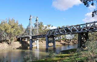
The Murrumbidgee River bridge, Carrathool is an heritage-listed road bridge across the Murrumbidgee River located at 244 Main Road, Carrathool, Carrathool Shire, New South Wales, Australia. The property is owned by Roads and Maritime Services, an agency of the Government of New South Wales. The bridge is also called the Carrathool Bridge over Murrumbidgee River and carrier the Sturt Highway across the river. It was added to the New South Wales State Heritage Register on 20 June 2000.

Ingalara Creek railway bridge, Michelago

The Ingalara Creek railway bridge is an heritage-listed former railway bridge that carried the Bombala railway line across Ingalara Creek at Michelago in the Snowy Monaro Regional Council local government area of New South Wales, Australia. It was designed by John Whitton in his capacity as Engineer-in-Chief for Railways and built in 1889. It is also known as the Michelago Rail Bridge over Ingalara Creek and the Ingalara Creek Railway Viaduct. The property is owned by RailCorp, an agency of the Government of New South Wales. It was added to the New South Wales State Heritage Register on 2 April 1999.

Bredbo River railway bridge, Bredbo

The Bredbo River railway bridge is a heritage-listed former railway bridge carrying the Bombala railway line over the Bredbo River at Bredbo in the Snowy Monaro Regional Council local government area of New South Wales, Australia. It was designed by John Whitton in his capacity as Engineer-in-Chief for Railways and built from 1881 to 1889. It is also known as the Bredbo Rail Bridge and the Bredbo River Railway Viaduct. The property is owned by RailCorp, an agency of the Government of New South Wales. It was added to the New South Wales State Heritage Register on 2 April 1999.

Williams River bridge, Clarence Town

Williams River bridge, Clarence Town is an heritage-listed bridge across the Williams River located at 567 Main Road, Clarence Town, Dungog Shire, New South Wales, Australia. It was designed by the New South Wales Public Works Department and built by J. K. McKenzie. The property is owned by Roads and Maritime Services, an agency of the Government of New South Wales. It was added to the New South Wales State Heritage Register on 20 June 2000.

Tenterfield Creek railway bridge, Sunnyside

The Tenterfield Creek railway bridge is an heritage-listed former railway bridge that carried the Main North line across the Tenterfield Creek from Sunnyside to Jennings, bothin the Tenterfield Shire local government area of New South Wales, Australia. It was designed by John Whitton and Engineer-in-Chief for NSW Government Railways and built in 1888. The bridge is also known as the Sunnyside rail bridge over Tenterfield Creek. The property is owned by RailCorp, an agency of the Government of New South Wales and was added to the New South Wales State Heritage Register on 2 April 1999.

Murrumbidgee River railway bridge, Gundagai

The Murrumbidgee River railway bridge is a heritage-listed railway bridge across the Murrumbidgee River located on the Tumut railway line at Gundagai in the Cootamundra-Gundagai Regional Council local government area of New South Wales, Australia. It was built in 1903. It is also known as the Gundagai Rail Bridge over Murrumbidgee River and the Murrumbidgee River Railway Bridge. The property is owned by RailCorp, an agency of the Government of New South Wales. It was added to the New South Wales State Heritage Register on 2 April 1999.

Manning River railway bridge, Taree

The Manning River railway bridge is an heritage-listed railway bridge that carries the North Coast line across the Manning River located at Mount George, near Taree in the Mid-Coast Council local government area of New South Wales, Australia. The bridge is also known as the Mount George Rail Bridge over Manning River. The property is owned by RailCorp, an agency of the Government of New South Wales. It was added to the New South Wales State Heritage Register on 2 April 1999.

Macleay River railway bridge, Kempsey

The Macleay River railway bridge is a heritage-listed railway bridge on the North Coast railway crossing the Macleay River from Kempsey to South Kempsey, both in the Kempsey Shire, New South Wales, Australia. The property is owned by RailCorp, an agency of the Government of New South Wales. It was added to the New South Wales State Heritage Register on 2 April 1999.

Leycester Creek railway bridge, Lismore

Leycester Creek railway bridge is a heritage-listed railway bridge on the mostly closed Murwillumbah railway line in Lismore, City of Lismore, New South Wales, Australia. The property is owned by RailCorp, an agency of the Government of New South Wales. It was added to the New South Wales State Heritage Register on 2 April 1999.

Yarraford Rail Bridge over Beardy Waters

Yarraford Rail Bridge over Beardy Waters is a heritage-listed closed railway bridge on the Main Northern line Glen Innes, Glen Innes Severn, New South Wales, Australia. It was designed by John Whitton in his capacity as Engineer-in-Chief for Railways and built in 1886. It is also known as Beardy River Railway Viaduct. The property is owned by RailCorp, an agency of the Government of New South Wales. It was added to the New South Wales State Heritage Register on 2 April 1999.

Severn River railway bridge, Dundee

Severn River railway bridge is a heritage-listed railway bridge on the Main Northern line at Dundee, Glen Innes Severn, New South Wales, Australia. It was designed by John Whitton in his capacity as Engineer-in-Chief for Railways and built in 1886. It is also known as Severn River Railway Viaduct. The property is owned by RailCorp, an agency of the Government of New South Wales. It was added to the New South Wales State Heritage Register on 2 April 1999.

Bowenfels rail viaducts railway bridges, New South Wales, Australia

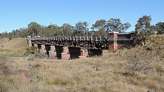
The Bowenfels rail viaducts are a series of heritage-listed railway viaducts and railway bridges over Farmers Creek on the Main Western line in Bowenfels, City of Lithgow, New South Wales, Australia. It was designed in two stages, by John Whitton as the Engineer-in-Chief for Railways, in 1870; and by engineering staff of New South Wales Government Railways in 1921; and was built from 1870 to 1921. It is also known as Farmers Creek viaducts. The property is owned by RailCorp, an agency of the Government of New South Wales. It was added to the New South Wales State Heritage Register on 2 April 1999. The viaduct are located approximately 159 kilometres (99 mi) west of Central railway station.

Rydal rail underbridges

Rydal rail underbridges is a heritage-listed railway bridge on the Main Western line at Rydal, City of Lithgow, New South Wales, Australia. The property is owned by RailCorp, an agency of the Government of New South Wales. It was added to the New South Wales State Heritage Register on 2 April 1999.

References

  1. 1 2 3 4 5 6 7 McLennan, Maxwell (19 July 1932). "Grafton Bridge: Today's opening". The Sydney Morning Herald. National Library of Australia . Retrieved 16 March 2013.
  2. 1 2 "Grafton Bridge - two tenders received - Dorman Long & Co. Ltd the lower". The Sydney Morning Herald. 22 June 1926. Retrieved 28 December 2013.
  3. 1 2 "Additional Crossing of the Clarence River: Feasibility Study Report" (PDF). NSW Roads and Traffic Authority. February 2003. ISBN   0731053702 . Retrieved 16 March 2013.
  4. Hauff, Maria (13 June 2007). "Grafton Bridge turns 75". ABC News. Australia: Australian Broadcasting Corporation . Retrieved 16 March 2013.
  5. "CLARENCE RIVER BRIDGE - ACCESS ON GRAFTON SIDE FITZROY STREET ROUTE CHOSEN". Daily Examiner (Grafton, NSW : 1915 - 1954). Daily Examiner. 9 July 1931. Retrieved 4 July 2016.
  6. "Funding doubts over second Grafton bridge". ABC News. Australia. 31 October 2008. Retrieved 16 March 2013.
  7. "Additional crossing of the Clarence River at Grafton: Recommended preferred option display" (PDF). Community update. Roads and Maritime Services. December 2012. Retrieved 16 March 2013.