
Sioux Falls Regional Airport, also known as Joe Foss Field, is a public and military use airport owned by the Sioux Falls Regional Airport Authority and located three nautical miles (6 km) northwest of the central business district of Sioux Falls, South Dakota, United States. Named in honor of aviator and Sioux Falls native Joe Foss, it serves the greater Sioux Falls area, as well as communities throughout eastern South Dakota, southwestern Minnesota and northwestern Iowa.

Bemidji Regional Airport is a public use airport located three nautical miles (6 km) northwest of the central business district of Bemidji, a city in Beltrami County, Minnesota, United States. It is owned by the city of Bemidji and Beltrami County.
Bandera State Airport is a public use airport located in Bandera, Washington, King County, Washington, United States. It is owned by the Washington State DOT Aviation Division.

W. K. Kellogg Airport is a city-owned, public-use, joint civil-military airport located three nautical miles (6 km) west of the central business district of Battle Creek, a city in Calhoun County, Michigan, United States. The airport is accessible by road from Helmer Road, and is located near I-94. It is included in the Federal Aviation Administration (FAA) National Plan of Integrated Airport Systems for 2017–2021, in which it is categorized as a regional general aviation facility. It is also known as W. K. Kellogg Regional Airport.

Robertson Field is a public use airport located one nautical mile (2 km) west-southwest of the central business district of Langdon, a city in Cavalier County, North Dakota, United States. It is owned by the Langdon Airport Authority. This airport is included in the National Plan of Integrated Airport Systems for 2011–2015, which categorized it as a general aviation facility.
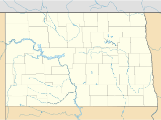
Casselton Robert Miller Regional Airport is a public airport located 4 miles (6.4 km) south of the central business district of Casselton, in Cass County, North Dakota, United States. It is owned by the Casselton Regional Airport Authority.

Marianna Municipal Airport is five miles northeast of Marianna, in Jackson County, Florida. The FAA's National Plan of Integrated Airport Systems for 2009–2013 categorized it as a general aviation airport. It was formerly Graham Air Base.
Harry Stern Airport is a public use airport in Richland County, North Dakota, United States. It is located one nautical mile (1.85 km) south of the central business district of Wahpeton, North Dakota and owned by the Wahpeton Airport Authority.
Hettinger Municipal Airport is a public use airport located in Adams County, North Dakota, United States and owned by the Adams County Airport Authority. The airport is one nautical mile (1.85 km) northwest of the central business district of Hettinger, North Dakota.
Harrold Municipal Airport is a city-owned, public-use airport located one nautical mile (1.85 km) northwest of the central business district of Harrold, in Hughes County, South Dakota, United States.
Britton Municipal Airport is a city-owned, public-use airport located two nautical miles northeast of the central business district of Britton, a city in Marshall County, South Dakota, United States. According to the FAA's National Plan of Integrated Airport Systems for 2009–2013, it is categorized as a general aviation airport.
Pine Ridge Airport is a public use airport located two nautical miles (3.7 km) east of the central business district of Pine Ridge, in Oglala Lakota County, South Dakota, United States. The airport is owned by the Oglala Sioux Tribe, which has its tribal headquarters at Pine Ridge on the Pine Ridge Indian Reservation. According to the FAA's National Plan of Integrated Airport Systems for 2009–2013, it is categorized as a general aviation facility.
Madison Municipal Airport is a city-owned public use airport located one nautical mile northeast of the central business district of Madison, a city in Lake County, South Dakota, United States. This airport is included in the FAA's National Plan of Integrated Airport Systems for 2009–2013, which categorized it as a general aviation facility.
Hillsboro Municipal Airport is a public use airport located three nautical miles south of the central business district of Hillsboro, a city in Traill County, North Dakota, United States. It is owned by the Hillsboro Municipal Airport Authority.
Mayville Municipal Airport is a city-owned, public-use airport located one nautical mile south of the central business district of Mayville, a city in Traill County, North Dakota, United States.
Rugby Municipal Airport is a public use airport located two nautical miles (4 km) northwest of the central business district of Rugby, a city in Pierce County, North Dakota, United States. It is owned by the Rugby Airport Authority. This airport is included in the National Plan of Integrated Airport Systems for 2011–2015, which categorized it as a general aviation facility.
Pembina Municipal Airport is a public use airport located one nautical mile (2 km) south of the central business district of Pembina, a city in Pembina County, North Dakota, United States. It is owned by the Pembina Airport Authority. This airport is included in the National Plan of Integrated Airport Systems for 2011–2015, which categorized it as a general aviation facility.

Martin Field is a privately owned, public use airport located three nautical miles (6 km) southwest of the central business district of South Sioux City, in Dakota County, Nebraska, United States.
Kenmare Municipal Airport is a public use airport located one nautical mile (2 km) southeast of the central business district of Kenmare, a city in Ward County, North Dakota, United States. Owned by the Kenmare Airport Authority, it is included in the National Plan of Integrated Airport Systems for 2011–2015, which categorized it as a general aviation facility.
Columbus Municipal Airport is a public use airport located one nautical mile (2 km) southwest of the central business district of Columbus, a city in Burke County, North Dakota, United States. It is owned by the Columbus Airport Authority.


