
Middletown is the largest city in Orange County, New York, United States. It lies in New York's Hudson Valley region, near the Wallkill River and the foothills of the Shawangunk Mountains. Middletown is situated between Port Jervis and Newburgh, New York. At the 2020 United States census, the city's population was 30,345, reflecting an increase of 2,259 from the 28,086 counted in the 2010 census. The ZIP Code is 10940. Middletown falls within the Kiryas Joel–Poughkeepsie–Newburgh Metropolitan Statistical Area, which belongs to the larger New York–Newark–Bridgeport, NY–NJ–CT–PA Combined Statistical Area.

The Delaware, Lackawanna and Western Railroad, also known as the DL&W or Lackawanna Railroad, was a U.S. Class 1 railroad that connected Buffalo, New York, and Hoboken, New Jersey, and by ferry with New York City, a distance of 395 miles (636 km). The railroad was incorporated in Pennsylvania in 1853, and created primarily to provide a means of transport of anthracite coal from the Coal Region in Northeast Pennsylvania to large coal markets in New York City. The railroad gradually expanded both east and west, and eventually linked Buffalo with New York City.

The Moodna Viaduct is a steel railroad trestle spanning Moodna Creek and its valley at the north end of Schunemunk Mountain in Cornwall, New York, near the hamlet of Salisbury Mills.

The Main Line is a commuter rail line owned and operated by New Jersey Transit running from Suffern, New York to Hoboken, New Jersey, in the United States. It runs daily commuter service and was once the north–south main line of the Erie Railroad. It is colored yellow on NJ Transit system maps, and its symbol is a water wheel.

NJ Transit Rail Operations is the rail division of NJ Transit. It operates commuter rail service in New Jersey, with most service centered on transportation to and from New York City, Hoboken, and Newark. NJ Transit also operates rail service in Orange and Rockland counties in New York under contract to Metro-North Railroad. The commuter rail lines saw 57,179,000 riders in 2023, making it the third-busiest commuter railroad in North America and the longest commuter rail system in North America by route length.
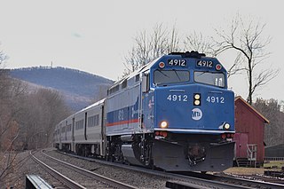
The Port Jervis Line is a predominantly single-track commuter rail line running between Suffern and Port Jervis, in the U.S. state of New York. At Suffern, the line continues south into New Jersey on NJ Transit's Main Line. The line is operated by NJ Transit Rail Operations under a contract with Metro-North Railroad (MNRR).

Salisbury Mills–Cornwall station is a commuter rail stop owned by Metro-North Railroad serving trains on the Port Jervis Line, located in the Beaver Dam Lake section of the town of Cornwall, New York. The station is located at the northern end of the Moodna Viaduct, accessible from NY 94.

Suffern station is a railroad station in the village of Suffern. The station, located on Ramapo Avenue in Suffern, services trains of New Jersey Transit's Main Line and Metro-North Railroad's Port Jervis Line. Suffern station serves as the terminal for Main Line trains, as trains continue north into Hillburn Yard. The next Main Line station, located in New Jersey, is Mahwah. The next Port Jervis Line station to the north is Sloatsburg. The station consists of two low-level side platforms for trains in both directions, neither of which are handicap accessible for the Americans with Disabilities Act of 1990.

Campbell Hall station is a commuter rail stop owned by Metro-North Railroad serving trains on the Port Jervis Line, located just south of the hamlet of Campbell Hall, New York in the town of Hamptonburgh. The station is located at the end of Watkins Road, off Egbertson Road. The station contains decorative lights, a long platform roof and an elevated mini-high platform at the east end of the station for access by riders in wheelchairs. Parking is on a permit/meter system.

Middletown–Town of Wallkill station, often just referred to as the Middletown station, is a commuter rail stop owned by Metro-North Railroad serving trains on the Port Jervis Line in the town of Wallkill, New York. The station is located in the latter municipality along the former Erie Railroad Graham Line.

Otisville station is a commuter rail stop owned by Metro-North Railroad serving trains on the Port Jervis Line, serving the village of Otisville, New York along with the town of Mount Hope. It is located a short distance off New York State Route 211 near the eastern village line.

Port Jervis station is a commuter rail stop owned by Metro-North Railroad serving trains on the Port Jervis Line, located in Port Jervis, New York. It is the western terminus of the Port Jervis Line.

The Port Jervis station is a disused train station at the corner of Jersey Avenue and Fowler Street in Port Jervis, New York. It was built in 1892 as a passenger station for the Erie Railroad by Grattan & Jennings in the Queen Anne style. For years it was the busiest passenger station on the railroad's Delaware Branch because Port Jervis is along the Delaware River near the tripoint of New York, New Jersey, and Pennsylvania. The long-distance passenger trains Erie Limited and the Lake Cities between Chicago and Hoboken served this station.

Paterson is a New Jersey Transit commuter railway station located on an elevated viaduct above Market Street in downtown Paterson, New Jersey. The railway through the station is double tracked, for north and south traffic on the NJT Main Line.

The Otisville Tunnel is a railroad tunnel that carries Metro-North Railroad's Port Jervis Line beneath the Shawangunk Ridge. It is the longest tunnel in the Metro-North system, at 5,314 feet (1,620 m) in length. Although the track curves at the western opening, the tunnel itself is a straight line, allowing an observer to see all the way through.

The Orange Heritage Trailway is a 19.5-mile (31.4 km) rail trail in Orange County, New York, that runs along the roadbed of the Erie Railroad's Main Line from Harriman, NY to nearby Middletown.

Harriman Station, formerly known as Turner Station until 1910, was the first station on the Erie Railroad Main Line west of Newburgh Junction in Harriman, New York. Built adjacent to Grove Street in Harriman, one of the earlier structures built here in 1838 was a three-story hotel-train station combination. This station caught fire in 1873 and was replaced by a one-story wooden structure. That structure remained in use for decades before it began decaying and was replaced in 1911 with a new station on land donated by the widow of Edward Henry Harriman. A new one-story structure was built on the land. The station was maintained as a one-story depot with an adjacent monument dedicated to the work of Charles Minot. Minot was a director of the Erie Railroad who, in 1851, while his train was stopped at Turner, made the first railroad call by telegraph.

George Edward Archer was an American architect. He became Chief Architect of the New York, Lake Erie and Western Railroad, later the Erie Railroad, in 1886, where he was responsible for planning and supervising the construction of stations, docks, piers and other structures for the railroad between New York and Chicago. Several stations built in the late 19th century in New Jersey and Upstate New York are attributed to him.

Middletown was the main station along the Erie Railroad mainline in the city of Middletown, New York. Located on Depot Street, the station was first opened in 1843 with the construction of the New York, Lake Erie and Western Railroad, which had originally terminated at Goshen. The station was located along the New York Division, which stretched from Pavonia Terminal in Jersey City, New Jersey, to the Sparrowbush station just north of Port Jervis.
The Erie Railroad Newburgh Branch is a mostly abandoned branch line that travels across the center of Orange County, New York. It survives as the CSX Vails Gate Spur between Newburgh and Vails Gate, but is abandoned between Vails Gate and the end of the line in Greycourt. When it opened in 1850, it was Newburgh's first railroad and remained the only line serving the city for over three decades until the first train operated from Newburgh along the West Shore Railroad in 1883.

