
The Salmon River is located in Idaho in the northwestern United States. The Salmon is also known as "The River of No Return". It flows for 425 miles (685 km) through central Idaho, draining a rugged, thinly populated watershed of 14,000 square miles (36,000 km2) and dropping more than 7,000 feet (2,100 m) between its headwaters, near Galena Summit above the Sawtooth Valley in the Sawtooth National Recreation Area, and its confluence with the Snake River. Measured at White Bird, its average discharge is 11,060 cubic feet per second. It is one of the largest rivers in the continental United States without a single dam on its mainstem.

The Kern River, originally Rio de San Felipe, later La Porciuncula, is a river in the U.S. state of California, approximately 165 miles (270 km) long. It drains an area of the southern Sierra Nevada mountains northeast of Bakersfield. Fed by snowmelt near Mount Whitney, the river passes through scenic canyons in the mountains and is a popular destination for whitewater rafting and kayaking. It is the southernmost major river system in the Sierra Nevada, and is the only major river in the Sierra that drains in a southerly direction.

The Feather River is the principal tributary of the Sacramento River, in the Sacramento Valley of Northern California. The river's main stem is about 73 miles (117 km) long. Its length to its most distant headwater tributary is just over 210 miles (340 km). The main stem Feather River begins in Lake Oroville, where its four long tributary forks join together—the South Fork, Middle Fork, North Fork, and West Branch Feather Rivers. These and other tributaries drain part of the northern Sierra Nevada, and the extreme southern Cascades, as well as a small portion of the Sacramento Valley. The total drainage basin is about 6,200 square miles (16,000 km2), with approximately 3,604 square miles (9,330 km2) above Lake Oroville.
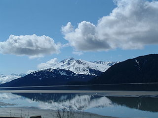
Turnagain Arm is a waterway into the northwestern part of the Gulf of Alaska. It is one of two narrow branches at the north end of Cook Inlet, the other being Knik Arm. Turnagain is subject to climate extremes and large tide ranges.
The Chandalar River is a 100-mile (160 km) tributary of the Yukon River in the U.S. state of Alaska. Its peak flow, recorded by the United States Geological Survey (USGS) between 1964 and 1974 at a stream gauge at Venetie, was 62,800 cubic feet per second (1,780 m3/s) on June 9, 1968.
The Kuzitrin River is a stream, 95 miles (153 km) long, on the Seward Peninsula in the U.S. state of Alaska. It begins at Kuzitrin Lake in the central region of the peninsula and flows 95 miles (153 km) west into the Imuruk Basin. The basin drains via the bay of Port Clarence to the Bering Sea. Kuzitrin tributaries include the Noxapaga, Kougarok, Kruzgamepa (Pilgrim), and Kugruk rivers.

Lagunitas Creek is a 24 miles (39 km)-long northward-flowing stream in Marin County, California. It is critically important to the largest spawning runs of endangered coho salmon in the Central California Coast Coho salmon Evolutionary Significant Unit. The stream's headwaters begin on the northern slopes of Mt. Tamalpais in the Coast Range and terminate in southeast Tomales Bay, 1.5 miles (2.4 km) northwest of Point Reyes Station, California. Lagunitas Creek feeds several reservoirs on Mt. Tamalpais that supply a major portion of the county's drinking water.

The Kiwalik River is a stream on the Seward Peninsula in the U.S. state of Alaska. The headwaters of the river originate in the eastern portion of the peninsula, around Granite Mountain. The river flows north to its mouth at Kiwalik Lagoon, Chukchi Sea. The start of the 20th century mining town of Candle is found on its western bank at the confluence of Candle Creek. The ore minerals and materials found in the river basin are galena, gold, pyrite, scheelite, silver and sphalerite, and the primary commodities are tungsten, lead and zinc.
The Koyuk River is a river on the Seward Peninsula of western Alaska, in the United States. The river originates in the interior of the peninsula, at the Lost Jim Lava Flow of the Bering Land Bridge National Preserve, where it flows southeast towards the mouth of Norton Bay on Norton Sound. The native village of Koyuk is located at its mouth. The two major tributaries are the Peace and Salmon rivers; other tributaries include Dime and Sweepstakes.

Cherry Creek is a large, swift-flowing stream in the Sierra Nevada mountain range, and is the largest tributary of the Tuolumne River. The creek is 40 miles (64 km) long measured to its farthest headwaters; the main stem itself is 26 miles (42 km) long, draining a watershed of 234 square miles (610 km2) in the Stanislaus National Forest. Part of the drainage also extends into the northwest corner of Yosemite National Park.

The Fish River is a waterway in the U.S. state of Alaska. The 47-mile-long (76 km) river rises in the Bendeleben Mountains and flows south to Golovnin Lagoon, before emptying into Golovnin Bay, Norton Sound, and the Bering Sea. The basin formed by the Fish River is known for its placer gold deposits, and in particular, the Niukluk River and its tributaries; production from this tributary valley is reported to be more than from any other place in the region. A galena mine existed 40 miles (64 km) from the sea, worked on occasion by a San Francisco corporation with a few hundred tons of ore taken to the city for smelting and refining for silver. Walter Curran Mendenhall found obscure fossils on Fish River at White Mountain.
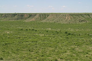
The White River is an intermittent stream in the South Plains of Texas and a tributary of the Brazos River of the United States. It rises 8 miles (13 km) west of Floydada in southwestern Floyd County at the confluence of Callahan and Runningwater Draws. From there, it runs southeast for 62 miles (100 km) to its mouth on the Salt Fork of the Brazos River in northwestern Kent County. Besides these two headwaters, which rise near Hale Center and in Curry County, New Mexico, respectively, other tributaries include Pete, Crawfish, and Davidson Creeks. The White River drains an area of 1,690 sq mi (4,377 km2).

The Kruzgamepa River is a 55-mile (89 km) tributary of the Kuzitrin River on the Seward Peninsula in the U.S. state of Alaska. The river begins at Salmon Lake, elevation 447 feet (136 m), and descends to 20 feet (6.1 m) above sea level at its mouth. In turn, the Kuzitrin River empties into the Imuruk Basin. The basin drains via the bay of Port Clarence to the Bering Sea.
Eldorado River is a waterway on the Seward Peninsula]] in the U.S. state of Alaska. It is situated 14 miles (23 km) west of Solomon. This river has its source within a few miles of Salmon Lake, from which it is separated by a low divide. It flows southeast through a broad gravel-filled valley for 30 miles (48 km) to Flambeau River before emptying into Safety Sound. Its headwaters reach the limestones of the Nome series and much of its course lies in a chlorite-albite-schist belt. The Eldorado River provides a southerly drainage into the Bering Sea.
Nome River is a waterway on the Seward Peninsula in the U.S. state of Alaska. It has its source in a narrow valley in the southern margin of the Kigluaik Mountains, 4.5 miles (7.2 km) west of Salmon Lake.
Salmon Lake is a natural lake on the Seward Peninsula in the U.S. state of Alaska. Situated 35 miles (56 km) north of Cape Nome, it drains into Port Clarence through Kruzgamepa River. The lake lies at the foot of the Kigluaik Mountains at an elevavation of about 442 feet (135 m). It has a water surface area of 1,800 acres (730 ha) and a drainage area of 81 square miles (210 km2). Its principal supply comes from Grand Central River, which enters it at its western end. A number of small streams also enter the lake from both the north and the south; Fox Creek and Jasper Creek are the most notable of these. Efforts to dam the lake in order to provide power and water supply to mining endeavors occurred from 1906-1907, However these plans were later dropped due to disputes over land ownership and water rights.

Sycamore Creek is a stream, tributary to the Kings River, in Fresno County, California.
Bluestone River is a waterway located on the Seward Peninsula in the U.S. state of Alaska. A tributary of the Tuksuk Channel from the south, Bluestone is a north-flowing stream situated 11 miles (18 km) southeast of Teller. It was named in 1900 by Edward Chester Barnard, topographer of the United States Geological Survey.

Noxapaga River is a 56-mile (90 km) tributary of the Kuzitrin River on the Seward Peninsula in the U.S. state of Alaska. Heading in the Bering Land Bridge National Preserve, it flows northwest for 4 miles (6 km), then west for 22 miles (35 km), then south for 30 miles (48 km) to its mouth on the larger river. Tributaries include the creeks of Aurora, Berry, Black, Bluff, Boulder, Buzzard, Frost, Garfield, Goodall, Goose, Grouse, Last Chance, Little Garfield, Mascot, Money, Peuk, Stony, Turner, and Winona.

Campbell Creek is one of several streams that flow through the city of Anchorage, Alaska. It runs for 21 miles from the Chugach Mountains to the Turnagain Arm of Cook Inlet.
