The Dent Blanche is a mountain in the Pennine Alps, lying in the canton of Valais in Switzerland. With its 4,357 metres (14,295 ft)-high summit, it is one of the highest peaks in the Alps.

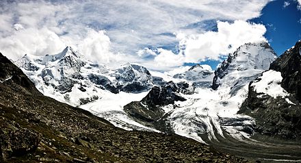
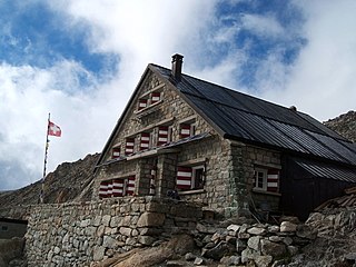
The Bertol Hut is a mountain hut overlooking the Bertol Pass, south of Arolla in the Swiss canton of Valais. It is known for its precarious position on a ridge at 3,311 metres (10,863 ft) south of the Pointe de Bertol and is accessed by a number of fixed ladders and chains from the glacier pass. All accesses to the hut involve glacier crossing. On its east side it overlooks the large plateau of the Mont Miné Glacier.

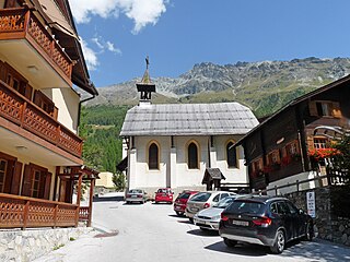
Arolla is a village in the municipality of Evolène in the canton of Valais in Switzerland.

The Ober Gabelhorn is a mountain in the Pennine Alps in Switzerland, located between Zermatt and Zinal.
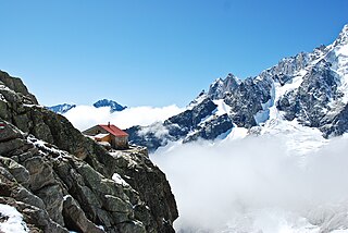
The Trient hut is a mountain hut in the Swiss alps, near the Swiss town of Martigny and the French town of Chamonix. The hut sits at an altitude of 3,170 m (10,400 ft), on a rock perched above the Trient Glacier. It can be reached on foot by mountaineers and strong hikers with experience of glacier travel. From the hut you can walk to the Albert Premier and Argentière huts in France, as well as the Cabane de Saleina (Switzerland) at the foot of the Aiguille d'Argentière. The hut is run by the SAC, the Swiss Alpine Club, and has 130 beds. It is a popular base for mountaineers exploring the area, e.g. Aiguille du Tour etc.

The Bishorn is a mountain in the Pennine Alps in Switzerland, just north of the Weisshorn.

Mont Dolent is a mountain in the Mont Blanc massif and lies on the border between Italy, Switzerland and France.

Champex is a village located in the French-speaking Swiss canton of Valais, part of the municipality of Orsières.

Tête de Milon is a mountain of the Swiss Pennine Alps, located east of Zinal in the canton of Valais. It belongs to the massif of the Weisshorn and lies west of the Turtmann Glacier.
Zinal is a village in Switzerland, located in the municipality of Anniviers in the canton of Valais. It lies at an elevation of 1,675 metres (5,495 ft) above sea level in the Swiss Alps in the Val de Zinal, a valley running from the Zinal Glacier, north of Dent Blanche to the village of Ayer, part of the Val d'Anniviers. With the Dent Blanche, four additional 4,000-metre (13,120 ft) peaks are located around the valley: Bishorn, Weisshorn, Zinalrothorn, and Ober Gabelhorn.

Val Ferret is the name of the two separate valleys, departing from the Col Ferret on the border between Italy and Switzerland, on the southern and eastern sides of the Mont Blanc Massif. The Swiss valley drains northeastwards towards Orsières and on into the Rhône basin; whereas the Italian valley drains southwestwards towards Courmayeur and on into the Po basin.

The Saleina Hut is a mountain hut in the Swiss Alps at 2,691 meters above sea level. It can be reached from the Val Ferret. The hut lies above the Saleina Glacier near the Aiguille d'Argentière in the Mont Blanc Massif, and has places for 48 people and is wardened between mid-June to mid-September.
The Cabane de l'A Neuve is a mountain hut in the Swiss Alps at 2,735 metres above sea level open for visitors. It can be reached from the Val Ferret. The hut lies below the Grand Darray on the south side in the Mont Blanc Massif. Other summits close to the hut are the Tour Noir, the Grande Lui and the Mont Dolent. Inauguration was 4 September 1927.

The Tracuit Hut is a mountain hut of the Swiss Alpine Club, located above Zinal in the canton of Valais. The hut lies at an elevation of 3,256 metres (10,682 ft) above sea level, at the Tracuit Pass, between Les Diablons and the Tête de Milon in the Pennine Alps.

The Valsorey Hut is a mountain hut of the Swiss Alpine Club, located south of Bourg-Saint-Pierre in the canton of Valais. The hut lies at a height of 3,030 metres above sea level, on the southwestern slopes of the Grand Combin in the Pennine Alps, facing Mont Vélan.

The Vignettes Hut is an alpine hut, located south of Arolla in the Swiss canton of Valais. It lies at a height of 3,160 metres above sea level, at the foot of the Pigne d'Arolla and near the Col de Chermotane in the Pennine Alps. All accesses to the hut involve glacier crossing.

The Grands Mulets Hut is a mountain refuge in the Mont Blanc massif in the French Alps at an altitude of 3,051 m. It is owned by the Club Alpin Francais. The hut is located on a pyramidal rock island, at the junction of two streams of the Bossons Glacier on the north side of Mont Blanc. If the state of the glacier is not too severe, the hut is wardened in summer and can be used as an alternative route of ascent to the summit of Mont Blanc, following the original historic route by the first ascensionists. Nowadays the hut is used more frequently by ski-mountaineers in spring, or as a more sheltered and alternative route of descent from Mont Blanc than the much more popular Goûter route, though route-finding can be difficult in fog and requires prior knowledge of the crevassed state of the Bossons glacier below the hut.

The Pigne de la Lé is a mountain of the Swiss Pennine Alps, located south of Zinal in the canton of Valais. It lies north of the Grand Cornier, on the range between the Moiry Glacier and the valley of Zinal.

The Dent Blanche Hut is a mountain hut of the Swiss Alpine Club, located south of Les Haudères in the canton of Valais. The hut lies at a height of 3,507 metres above sea level, at the foot of the Dent Blanche in the Pennine Alps. The hut, located at the upper end of the valley of Hérens near the watershed with the valley of Zermatt, overlooks the Ferpècle Glacier.

The Dix Hut is a mountain hut of the Swiss Alpine Club, located south of Hérémence in the canton of Valais. The hut lies above the Cheilon Glacier, at a height of 2,928 metres above sea level, approximately halfway between the Lac des Dix and the Mont Blanc de Cheilon.