
Mont Blanc is the highest mountain in the Alps and Western Europe, and the highest mountain in Europe outside the Caucasus mountains, rising 4,805.59 m (15,766 ft) above sea level, located on the French-Italian border. It is the second-most prominent mountain in Europe, after Mount Elbrus, and the 11th most prominent mountain in the world.

The Pennine Alps, sometimes referred to as the Valais Alps, are a mountain range in the western part of the Alps. They are located in Italy and Switzerland (Valais).

The Matterhorn is a mountain of the Alps, straddling the main watershed and border between Italy and Switzerland. It is a large, near-symmetric pyramidal peak in the extended Monte Rosa area of the Pennine Alps, whose summit is 4,478 metres (14,692 ft) above sea level, making it one of the highest summits in the Alps and Europe. The four steep faces, rising above the surrounding glaciers, face the four compass points and are split by the Hörnli, Furggen, Leone/Lion, and Zmutt ridges. The mountain overlooks the Swiss town of Zermatt, in the canton of Valais, to the northeast; and the Italian town of Breuil-Cervinia in the Aosta Valley to the south. Just east of the Matterhorn is Theodul Pass, the main passage between the two valleys on its north and south sides, which has been a trade route since the Roman Era.

The Diablerets are a huge ice-covered mountain massif of the Alps, culminating at the Sommet des Diablerets (VS) at 3,216 metres (10,551 ft) above sea level and almost straddling the border between the Swiss cantons of Vaud (VD) and Valais (VS). The northeastern part of the massif stretches also into the canton of Bern (BE).

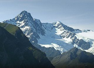
The Dent Blanche is a mountain in the Pennine Alps, lying in the canton of Valais in Switzerland. At 4,357 m (14,295 ft)-high, it is one of the highest peaks in the Alps.

Monte Rosa is a mountain massif in the eastern part of the Pennine Alps, on the border between Italy and Switzerland (Valais). The highest peak of the massif, amongst several peaks of over 4.000 m, is the Dufourspitze, the second highest mountain in the Alps and western Europe, after Mont Blanc. The east face of the Monte Rosa towards Italy has a height of about 2.400 meters and is the highest mountain wall of the Alps.

The Grand Combin is a mountain massif in the western Pennine Alps in the canton of Valais. At a height of 4,309 metres (14,137 ft) the summit of Combin de Grafeneire is one of the highest peaks in the Alps and the second most prominent of the Pennine Alps. The Grand Combin is also a large glaciated massif consisting of several summits, among which three are above 4000 metres. The highest part of the massif is wholly in Switzerland, although the border with Italy lies a few kilometres south.

Mont Pelvoux is a mountain in the Massif des Écrins in the French Alps. It stands 3,946 m (12,946 ft) in elevation.
Les 2 Alpes is a ski resort in the French department of Isère, Auvergne-Rhône-Alpes. The village sits at 1,650 m (5,413 ft) and lifts run to 3,600 m (11,811 ft). It has the largest skiable glacier in Europe and is France's second oldest ski resort behind Chamonix. It has the longest, normally open full on-piste vertical available in the world. It is a 71 km (44 mi) drive southeast of Grenoble.
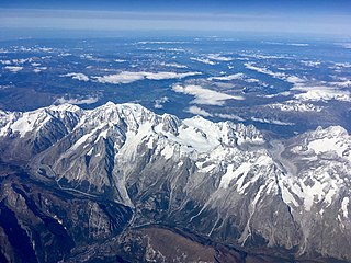
The Mont Blanc massif is a mountain range in the Alps, located mostly in France and Italy, but also straddling Switzerland at its northeastern end. It contains eleven major independent summits, each over 4,000 metres (13,123 ft) in height. It is named after Mont Blanc, the highest point in western Europe and the European Union. Because of its considerable overall altitude, a large proportion of the massif is covered by glaciers, which include the Mer de Glace and the Miage Glacier – the longest glaciers in France and Italy, respectively.

The Ober Gabelhorn is a mountain in the Pennine Alps in Switzerland, located between Zermatt and Zinal.

The Zinalrothorn is a mountain in the Pennine Alps in Switzerland. Its name comes from the village of Zinal lying on the north side and from the German word Rothorn which means Red Peak. When it was first climbed in 1864 the mountain was known locally as Moming.

Mont Dolent is a mountain in the Mont Blanc massif and lies on the border between Italy, Switzerland and France.
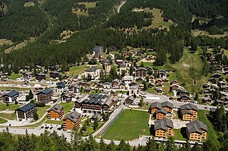
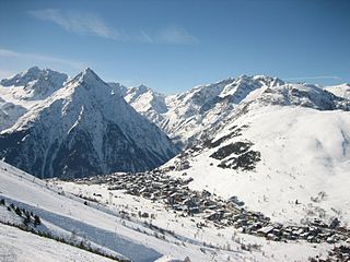
Zinal is a village in Switzerland, located in the municipality of Anniviers in the canton of Valais. It lies at an elevation of 1,675 metres (5,495 ft) above sea level in the Swiss Alps in the Val de Zinal, a valley running from the Zinal Glacier, north of Dent Blanche to the village of Ayer, part of the Val d'Anniviers. With the Dent Blanche, four additional 4,000-metre (13,120 ft) peaks are located around the valley: Bishorn, Weisshorn, Zinalrothorn, and Ober Gabelhorn.
The Grand Mountet Hut is a mountain hut located in the Pennine Alps near Zinal in the canton of Valais in Switzerland. It is used at a start point for the ascents of Besso, Zinalrothorn, Ober Gabelhorn, Trifthorn, Mont Durand, Pointe de Zinal, Grand Cornier and Dent Blanche.

Kílian Jornet is a professional long-distance trail runner and ski mountaineer. Jornet has won some of the most prestigious ultramarathons, including the Ultra-Trail du Mont-Blanc multiple times, Grand Raid, Western States and Hardrock.
The Aiguille des Glaciers is a mountain in the Mont Blanc massif of the Graian Alps. It lies on the borders of Savoie and Haute-Savoie in France and Aosta Valley in Italy.

The Miage Glacier is a debris-covered glacier in the upper Aosta Valley, in northwestern Italy.

The Aiguille de Tré-la-Tête is a mountain in the south of the Mont Blanc massif. Its highest point, the central southeast pinnacle, is 3,930 metres (12,894 ft) above sea level and is located in Italy. Only the northwest pinnacle is situated on the border with France. It forms a chain with the Dômes de Miage.

Val de Bagnes, also called the Vallée de Bagnes is a valley located in the Entremont District in the Canton of Valais of Switzerland.

