
Interstate 96 (I-96) is an east–west Interstate Highway that runs for approximately 192 miles (309 km) entirely within the Lower Peninsula of the US state of Michigan. The western terminus is at an interchange with US Highway 31 (US 31) and Business US 31 on the eastern boundary of Norton Shores southeast of Muskegon, and the eastern terminus is at I-75 near the Ambassador Bridge in Detroit. From Grand Rapids through Lansing to Detroit, the freeway parallels Grand River Avenue, never straying more than a few miles from the decommissioned US 16. The Wayne County section of I-96 is named the Jeffries Freeway from its eastern terminus to the junction with I-275 and M-14. Though maps still refer to the freeway as the Jeffries, the portion within the city of Detroit was renamed by the state legislature as the Rosa Parks Memorial Highway in December 2005 in honor of the late civil rights pioneer. There are four auxiliary Interstates as well as two current and four former business routes associated with I-96.
Wyoming is a city in Kent County in the U.S. state of Michigan. The population was 76,501 at the 2020 census. Wyoming is the second most-populated community in the Grand Rapids metropolitan area and is bordered by Grand Rapids on the northeast. After Grand Rapids, it is also the second most-populated city in West Michigan.

M-37 is a north–south state trunkline highway in the US state of Michigan. The southern terminus is near the border between Kalamazoo and Calhoun counties at exit 92 of Interstate 94 (I-94) southwest of Battle Creek. The northern terminus is at the Mission Point Light on Old Mission Point in Grand Traverse County. In between, the highway connects Battle Creek, Grand Rapids and Traverse City. Motorists will travel through agricultural land, forests, suburbs and large cities along the way. The section of M-37 on the Old Mission Peninsula was designated what is now a Pure Michigan Scenic Byway in 2008.
Interstate 196 (I-196) is an auxiliary Interstate Highway that runs for 80.6 miles (129.7 km) in the US state of Michigan. It is a state trunkline highway that links Benton Harbor, South Haven, Holland, and Grand Rapids. In Kent, Ottawa, and Allegan counties, I-196 is known as the Gerald R. Ford Freeway, or simply the Ford Freeway, after President Gerald Ford, who was raised in Grand Rapids and served Michigan in the House of Representatives for 25 years. This name generally refers only to the section between Holland and Grand Rapids. I-196 changes direction; it is signed as a north–south highway from its southern terminus to the junction with US Highway 31 (US 31) just south of Holland, and as an east–west trunkline from this point to its eastern terminus at an interchange with I-96, its parent highway. There are three business routes related to the main freeway. There are two business loops and one business spur that serve South Haven, Holland and the Grand Rapids areas. Another business spur for Muskegon had been designated relative to the I-196 number.

US Highway 16 (US 16), also called Grand River Avenue for much of its length in the state, was one of the principal roads prior to the post-World War II construction of freeways in the state of Michigan. Before the creation of the United States Numbered Highway System in 1926, the highway had been designated as a state highway numbered M-16. The modern route of Grand River Avenue cuts across the Lower Peninsula in a northwest–southeast fashion from near Grand Rapids to Detroit. Before the late 1950s and early 1960s, US 16 followed other roads between Muskegon and Grand Rapids, and then Grand River Avenue through Lansing to Detroit. In the years immediately preceding the creation of the Interstate Highway System, US 16 was shifted from older roads to newer freeways. Later, it was co-designated as an Interstate. When the gap in the freeway was filled in around Lansing, the US 16 designation was decommissioned in the state. The freeway was solely designated Interstate 96 (I-96) east of Grand Rapids and I-196 west of that city.
M-6, or the Paul B. Henry Freeway, is a 19.7-mile-long (31.7 km) east–west freeway and state trunkline highway in the United States that serves portions of southern Kent and eastern Ottawa counties south of Grand Rapids, Michigan. Although the freeway is named for Paul B. Henry, local residents and the press continue to use the original name, South Beltline as well on occasion. The freeway connects Interstate 196 (I-196) on the west with I-96 on the east. M-6 also provides a connection to U.S. Highway 131 (US 131) in the middle of its corridor while running through several townships on the south side of the Grand Rapids metropolitan area in Western Michigan. Each end is in a rural area while the central section has suburban development along the trunkline.
The A Line is a 48.5-mile (78.1 km) light rail line in Los Angeles County, California. The A Line runs east-west between Azusa and Pasadena, then north-south between Pasadena and Long Beach, via Downtown Los Angeles. The A Line is currently the longest light rail line in the world, surpassing the Coast Tram in Belgium.

The Interurban Transit Partnership, branded as The Rapid, is the public transit operator serving Grand Rapids, Michigan and its suburbs. In 2023, the system had a ridership of 6,239,500, or about 23,800 per weekday.

The Lane Cove Tunnel is a 3.6-kilometre (2.2 mi) twin-tunnel tollway in Sydney, New South Wales that is part of the Sydney Orbital Network. Owned by toll road operator Transurban, It connects the M2 Motorway at North Ryde with the Gore Hill Freeway at Artarmon and forms part of Sydney's M2 route, with the M2 Hills Motorway constituting the rest of the M2 route.

US Highway 131 (US 131) is a north–south United States Highway, of which all but 0.64 of its 269.96 miles are within the state of Michigan. The highway starts in rural Indiana south of the state line as a state road connection to the Indiana Toll Road. As the road crosses into Michigan it becomes a state trunkline highway that connects to the metropolitan areas of Kalamazoo and Grand Rapids before continuing north to its terminus at Petoskey. US 131 runs as a freeway from south of Portage through to Manton in the north. Part of this freeway runs concurrently with Interstate 296 (I-296) as an unsigned designation through Grand Rapids. US 131 forms an important corridor along the western side of the Lower Peninsula of Michigan, running through rural farm and forest lands as well as urban cityscapes. Various names have been applied to the roadway over the years. The oldest, the Mackinaw Trail, originated from an Indian trail in the area while other names honored politicians. An attempt to dedicate the highway to poet James Whitcomb Riley failed to gain official support in Michigan.

The Michigan State University College of Human Medicine (MSUCHM) is an academic division of Michigan State University (MSU) that grants the Doctor of Medicine (MD) degree, emphasizing patient-centered care and a biopsychosocial approach to caring for patients. Required courses at the college reinforce the importance of ethics and professionalism in medicine. In 2013, U.S. News & World Report ranked the college 46th for primary care. The college was also ranked for family medicine and rural medicine. More than 4,000 M.D.s have graduated from the college. Pre-clinical campuses are located on MSU's main campus in East Lansing, Michigan and in downtown Grand Rapids, Michigan, while the clinical rotations are at seven community campuses located throughout Michigan.

The Regional Connector Transit Project constructed a 1.9-mile (3.1 km) light rail tunnel for the Los Angeles Metro Rail system in Downtown Los Angeles. It connected the A and E lines with the former L Line. The A and E lines previously both terminated at 7th Street/Metro Center station, coming from Long Beach and Santa Monica, respectively, while the L Line ran through Little Tokyo/Arts District to either Azusa or East Los Angeles. Now the A and E lines continue together through new stations at Grand Avenue Arts/Bunker Hill, Historic Broadway, and Little Tokyo/Arts District. From there, they diverge on the former L Line toward Azusa and East Los Angeles, respectively. The project provides a one-seat ride into the core of Downtown for passengers on those lines who previously needed to transfer, thus reducing or altogether eliminating many transfers of passengers traveling across the region via Downtown Los Angeles.
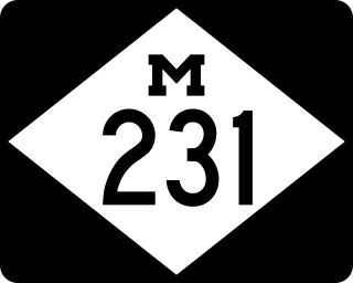
M-231 is the designation of a state trunkline highway in the Lower Peninsula of the US state of Michigan that serves as a partial bypass to US Highway 31 (US 31) around Grand Haven. This highway was built south of Interstate 96 (I-96) as an additional crossing over the Grand River. The route runs from M-45 northward and across the river to a connection with I-96 near the current M-104 interchange.
The Belknap Lookout Neighborhood is located in Grand Rapids, Michigan.

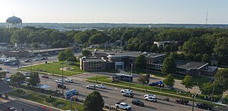
Grand Rapids Medical Mile is a designated area within the city of Grand Rapids, Michigan. It began with medical-related development in the Hillside District of Grand Rapids, Michigan, bordering both sides of Michigan Street. More than a decade later it encompasses an area five times larger, expanding east further down Michigan St.and north across Interstate 196. It has also been referred to as Grand Rapids Medical Corridor, Michigan Street Medical Corridor, Health Hill, Medical Hill, and Pill Hill, among other names.

Wilburton station is a future Link light rail station in Bellevue, Washington, which will be served by the 2 Line. The elevated station is scheduled to open in April 2024 as part of the line's starter segment. It will serve the area immediately east of Downtown Bellevue, including Lake Bellevue and the Overlake Hospital Medical Center.
Grand Rapids is a city and county seat of Kent County in the U.S. state of Michigan. At the 2020 census, the city had a population of 198,893 which ranks it as the second most-populated city in the state after Detroit. Grand Rapids is the central city of the Grand Rapids metropolitan area, which has a population of 1,087,592 and a combined statistical area population of 1,383,918.
Transportation in metropolitan Detroit comprises an expansive system of roadways, multiple public transit systems, a major international airport, freight railroads, and ports. Located on the Detroit River along the Great Lakes Waterway, Detroit is a significant city in international trade, with two land crossings to Canada. Three primary Interstate highways serve the region.
