
Vancouver is a major city in western Canada, located in the Lower Mainland region of British Columbia. As the most populous city in the province, the 2021 census recorded 662,248 people in the city, up from 631,486 in 2016. The Greater Vancouver area had a population of 2,642,825 in 2021, making it the third-largest metropolitan area in Canada. Vancouver has the highest population density in Canada, with over 5,400 people per square kilometre. Vancouver is one of the most ethnically and linguistically diverse cities in Canada: 52 percent of its residents are not native English speakers, 48.9 percent are native speakers of neither English nor French, and 50.6 percent of residents belong to visible minority groups.

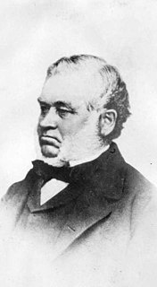
Frederick Buscombe, was the 11th Mayor of Vancouver, British Columbia, Canada. He served from 1905 to 1906. A glassware and china merchant, he was a President of the Vancouver Board of Trade in 1900.

Gastown is the original settlement that became the core of the city of Vancouver, British Columbia, Canada, and a national historic site and a neighbourhood in the northwest section of the Downtown Eastside, adjacent to Downtown Vancouver.

John Deighton, better known as "Gassy Jack", was a bar-owner in British Columbia. The Gastown neighbourhood of Vancouver, British Columbia takes its name from him.
Vancouver Public Library (VPL) is the public library system for the city of Vancouver, British Columbia. In 2013, VPL had more than 6.9 million visits with patrons borrowing nearly 9.5 million items including: books, ebooks, CDs, DVDs, newspapers and magazines. Across 22 locations and online, VPL serves nearly 428,000 active members and is the third-largest public library system in Canada.
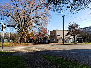
Hastings–Sunrise is a neighbourhood located in the northeastern corner of the city of Vancouver, British Columbia.

The Dominion Building is a commercial building in Vancouver, British Columbia, Canada. Located on the edge of Gastown, it was Vancouver's first steel-framed high-rise. At 53 m (175 ft), the thirteen-storey, Second Empire style building was the tallest commercial building in the British Empire upon its completion in 1910. Its architect was John S. Helyer, who is said to have died after falling off the staircase in the front of the building, though this is an urban legend.
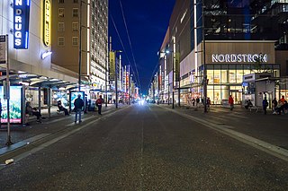
Granville Street is a major street in Vancouver, British Columbia, Canada, and part of Highway 99. Granville Street is most often associated with the Granville Entertainment District and the Granville Mall. This street also cuts through residential neighbourhoods like Shaughnessy and Marpole via the Granville Street Bridge.
The Vancouver Police Department (VPD) is the police force for the City of Vancouver in British Columbia, Canada. It is one of several police departments within the Metro Vancouver Area and is the second largest police force in the province after RCMP "E" Division.
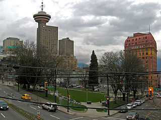
Victory Square is a park in Vancouver, British Columbia, Canada. The square is bordered by West Hastings Street to the northeast, West Pender Street to the southwest, Cambie Street to the southeast, and Hamilton Street to the northwest. The term is also used to refer to the neighbourhood immediately surrounding the square.

Downtown Vancouver is the main central business district and the city center neighbourhood of Metro Vancouver, located on the northwestern shore of the Burrard Peninsula in the Lower Mainland region of British Columbia. The Downtown occupies most of the north shore of the False Creek inlet, which incises into the Burrard Peninsula creating the namesaked Downtown Peninsula, where the West End neighbourhood and Stanley Park are also located.

The history of Vancouver is one that extends back thousands of years, with its first inhabitants arriving in the area following the Last Glacial Period. Vancouver is situated in British Columbia, Canada; with its location near the mouth of the Fraser River and on the waterways of the Strait of Georgia, Howe Sound, Burrard Inlet, and their tributaries. Vancouver has, for thousands of years, been a place of meeting, trade, and settlement.
A townsite is a legal subdivision of land for the development of a town or community. In the historical development of the United States, Canada, and other former British colonial nations, the filing of a townsite plat or plan (Canada) was often the first legal act in the establishment of a new town or community.
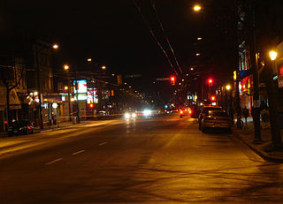
Main Street is a major north–south thoroughfare bisecting Vancouver, British Columbia, Canada. It runs from Waterfront Road by Burrard Inlet in the north, to Kent Avenue alongside the north arm of the Fraser River in the south.

The Great Vancouver Fire destroyed most of the newly incorporated city of Vancouver, British Columbia, Canada, on June 13, 1886. It started as two land clearing fires to the west of the city. The first fire was further away from the city and was clearing land for the roundhouse of the terminus of the Canadian Pacific Railway. The second fire was clearing land to extend the city to the west. The Great Fire occurred shortly after the township of Granville was incorporated into the City of Vancouver.
Captain Edward Stamp was an English mariner and entrepreneur who contributed to the early economic development of British Columbia and Vancouver Island. Born at Alnwick in Northumberland, Stamp served as the captain of a steam transport in the Crimean War in 1854.
This is a timeline of the history of Vancouver.
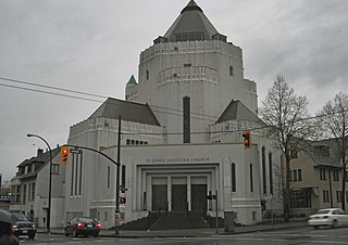
St. James' Anglican Church is a unique church building in the Diocese of New Westminster of the Anglican Church of Canada located at the north-east corner of East Cordova Street and Gore Avenue in the City of Vancouver, British Columbia, Canada in what is now its east Downtown and Strathcona neighbourhoods containing the Downtown Eastside district.

The architecture of Vancouver and the Greater Vancouver area holds a combination of modern architectural styles, ranging from the 20th century Edwardian style to the 21st century modernist style and beyond. Initially, the city's architects embraced styles and ideas developed in Europe and the United States with only limited local variation.
