
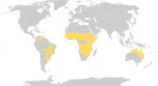
In physical geography, a steppe is an ecoregion, in the montane grasslands and shrublands and temperate grasslands, savannas and shrublands biomes, characterized by grassland plains without trees apart from those near rivers and lakes. In South Africa, they are referred to as veld. The prairie of North America is an example of a steppe, though it is not usually called such. A steppe may be semi-arid or covered with grass or shrubs or both, depending on the season and latitude. The term is also used to denote the climate encountered in regions too dry to support a forest but not dry enough to be a desert. The soil is typically of chernozem type.

Temperate grasslands, savannahs, and shrublands is a terrestrial habitat type defined by the World Wide Fund for Nature. The predominant vegetation in this biome consists of grass and/or shrubs. The climate is temperate and ranges from semi-arid to semi-humid. The habitat type differs from tropical grasslands in the annual temperature regime as well as the types of species found here.

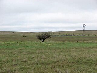
Grasslands are areas where the vegetation is dominated by grasses (Poaceae); however, sedge (Cyperaceae) and rush (Juncaceae) families can also be found along with variable proportions of legumes, like clover, and other herbs. Grasslands occur naturally on all continents except Antarctica. Grasslands are found in most ecoregions of the Earth. For example, there are five terrestrial ecoregion classifications (subdivisions) of the temperate grasslands, savannas, and shrublands biome (ecosystem), which is one of eight terrestrial ecozones of the Earth's surface.
Tropical and subtropical grasslands, savannas, and shrublands is a terrestrial habitat type defined by the World Wide Fund for Nature.. The biome is dominated by grass and/or shrubs located in semi-arid to semi-humid climate regions of subtropical and tropical latitudes.

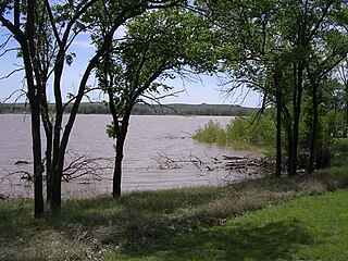
Flooded grasslands and savannas is a terrestrial habitat type of the WWF biogeographical system, consisting of large expanses or complexes of flooded grasslands. These areas support numerous plants and animals adapted to the unique hydrologic regimes and soil conditions. Large congregations of migratory and resident waterbirds may be found in these regions. However, the relative importance of these habitat types for these birds as well as more vagile taxa typically varies as the availability of water and productivity annually and seasonally shifts among complexes of smaller and larger wetlands throughout a region.

Montane grasslands and shrublands is a habitat type defined by the World Wildlife Fund. The biome includes high altitude grasslands and shrublands around the world. The term "montane" in the name of the biome refers to "high altitude", rather than the ecological term which denotes the region below treeline.

National Grassland is a classification of protected and managed federal lands in the United States authorized by Title III of the Bankhead–Jones Farm Tenant Act of 1937. For administrative purposes, they are essentially identical to United States National Forests, except that grasslands are areas primarily consisting of prairie. Like National Forests, National Grasslands may be open for hunting, grazing, mineral extraction, recreation and other uses. Various National Grasslands are typically administered in conjunction with nearby National Forests.

Calcareous grassland is an ecosystem associated with thin basic soil, such as that on chalk and limestone downland. Plants on calcareous grassland are typically short and hardy, and include grasses and herbs such as clover. Calcareous grassland is an important habitat for insects, particularly butterflies, and is kept at a plagioclimax by grazing animals, usually sheep and sometimes cattle. Rabbits used to play a part but due to the onset of myxomatosis their numbers decreased so dramatically that they no longer have much of a grazing effect.

Pawnee National Grassland is a United States National Grassland located in northeastern Colorado on the Colorado Eastern Plains. The grassland is located in the South Platte River basin in remote northern and extreme northeastern Weld County between Greeley and Sterling. It comprises two parcels totaling 193,060 acres (78,130 ha) largely between State Highway 14 and the Wyoming border. The larger eastern parcel lies adjacent to the borders of both Nebraska and Wyoming. It is administered in conjunction with the Arapaho-Roosevelt National Forest from the U.S. Forest Service office in Fort Collins, Colorado, with a local ranger district office in Greeley.

Butte Valley National Grassland is a 18,425-acre (7,456 ha) United States National Grassland located in northern California. Administered by the United States Forest Service, it is located in northern Siskiyou County, near the Oregon border, between the communities of Dorris and Macdoel along U.S. Highway 97. It was dedicated in July 1991 as the nation's 20th National Grassland. It is administered as part of the Klamath National Forest, and is the sole National Grassland in California and in Region 5 of the Forest Service. Administrative offices are located in Macdoel, California.

Comanche National Grassland is a National Grassland located in southeastern Colorado, United States. It is the sister grassland of Cimarron National Grassland and contains both prairie grasslands and canyons. It is separated into two sections, each operated by a local ranger district, one of which is in Springfield and the other of which is in La Junta. The grassland is administered by the Forest Service together with the Pike and San Isabel National Forests, and the Cimarron National Grassland, from common headquarters located in Pueblo, Colorado.

Caddo National Grassland is a National Grassland in the southern Great Plains, consisting of two separate sections located in northeastern and southeastern Fannin County, Texas, United States. It is a 17,873-acre (7,233 ha) protected area that was purchased in the 1930s. The goal of the park when purchased was to restore the eroded soil. There are two developed recreation areas around Lake Davy Crockett, which is 388 acres (157 ha) in size. The grassland is divided into two units: Bois d'Arc Creek and Ladonia.

Crooked River National Grassland is a National Grassland located in Jefferson County in the north-central part of the U.S. state of Oregon. It has a land area of 173,629 acres (70,265 ha). It contains two National Wild and Scenic Rivers, the Deschutes River and the Crooked River. The grassland is managed together with the Ochoco National Forest from Forest Service offices in Prineville. There are local ranger district offices located in Madras, its nearest city.

Lyndon B. Johnson (LBJ) National Grassland is a National Grassland located in the Great Plains of the northern part of the U.S. state of Texas near Decatur and within an hour's drive from Fort Worth. It is primarily used for recreation such as hiking, camping, horseback riding, fishing and hunting. It is also used as grazing land for cattle and other livestock.
McClellan Creek National Grassland is a National Grassland located in southern Gray County, Texas, United States. It was purchased with the goal of restoring badly eroded land to its natural state. The grassland is administered by the U.S. Forest Service together with Cibola National Forest and Black Kettle, Kiowa, and Rita Blanca National Grasslands, from common headquarters located in Albuquerque, New Mexico. The grassland is part of the combined Black Kettle and McClellan Creek Ranger District with offices in Cheyenne, Oklahoma.
Rita Blanca National Grassland is a National Grassland on the Great Plains near the community of Texline in northwest Dallam County, Texas, in the Texas Panhandle, and in southern Cimarron County, Oklahoma, in the western Oklahoma Panhandle. The principal city in the area is Dalhart, Texas, which houses the XIT Museum.

The Mongolian-Manchurian grassland ecoregion, also known as the Mongolian-Manchurian steppe, in the temperate grassland Biome, is found in Mongolia, the Chinese Autonomous region of Inner Mongolia and northeastern China.

Great Valley Grasslands State Park is a state park of California, USA, preserving a parcel of remnant native grassland in the San Joaquin Valley. Such a temperate grasslands, savannas, and shrublands biome was once widespread throughout the whole Central Valley. The 2,826-acre (1,144 ha) park was established in 1982. Largely undeveloped, it was formed by combining two former state park units: San Luis Island and Fremont Ford State Recreation Area. Its chief attractions for visitors are spring wildflowers, fishing, and wildlife watching.
Tussock grasses or bunch grasses are a group of grass species in the Poaceae family. They usually grow as singular plants in clumps, tufts, hummocks, or bunches, rather than forming a sod or lawn, in meadows, grasslands, and prairies. As perennial plants, most species live more than one season. Tussock grasses are often found as forage in pastures and ornamental grasses in gardens.

The Conscience Point National Wildlife Refuge was established July 20, 1971 as a land gift from Stanley Howard. The 60-acre (24 ha) refuge is located in the hamlet of North Sea on the north shore of Long Island's south fork. The refuge protects grasslands, oak-beech forest, shrub habitats, kettle holes, freshwater marsh and salt marsh.


