Great Boiling Spring Park

Last updated
Great Boiling Spring Park

Hot spring in Gerlach, Nevada.jpg

Hot Springs In Gerlach
Location Gerlach, Nevada
Coordinates 40°39′42″N119°21′56″W / 40.66167°N 119.36556°W / 40.66167; -119.36556 Coordinates: 40°39′42″N119°21′56″W / 40.66167°N 119.36556°W / 40.66167; -119.36556
Operated by none, is private property
Open no

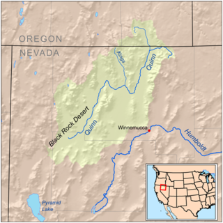
Great Boiling Spring Park [1] is a historical name for a former park that was on private property near Gerlach, Nevada, in a region known as the Black Rock Desert. The spring is not currently accessible by the public and has not been so since the 1990s. The park is on top of one of Nevada's most geothermally active[ citation needed ] regions, and contains dozens of hot springs and thermal pools. Great Boiling Spring [2] is fenced off to keep swimmers out. In the 1960s and 1970s, the park was a popular weekend destination for Nevada residents.

Gerlach, Nevada Census-designated place in Nevada, United States

Gerlach, Nevada is a census-designated place (CDP) in Washoe County, Nevada, United States. The population was 206 at the 2010 census. It is part of the Reno–Sparks Metropolitan Statistical Area. Prior to 2010, Gerlach was part of the Gerlach–Empire census-designated place. The town of Empire is now a separate CDP. The next nearest town, Nixon, is 60 miles (100 km) to the south on a reservation owned by the Pyramid Lake Paiute Tribe. The Fly Geyser is located near Gerlach.

Black Rock Desert

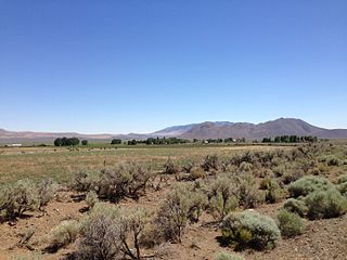
The Black Rock Desert is a semi-arid region (in the Great Basin shrub steppe eco-region), of lava beds and playa, or alkali flats, situated in the Black Rock Desert–High Rock Canyon Emigrant Trails National Conservation Area, a silt playa 100 miles (160 km) north of Reno, Nevada that encompasses more than 300,000 acres (120,000 ha) of land and contains more than 120 miles (200 km) of historic trails. It is in the northern Nevada section of the Great Basin with a lakebed that is a dry remnant of Pleistocene Lake Lahontan.

Related Research Articles

Quinn River river in the United States of America

The Quinn River, once known as the Queen River, is an intermittent river, approximately 110 miles (180 km) long, in the desert of northwestern Nevada in the United States. It drains an enclosed basin inside the larger Great Basin.

Ward Creek (Lake Tahoe)

Ward Creek is a 6.1-mile (9.8 km) eastward-flowing stream in Placer County, California, USA. The creek flows into Lake Tahoe 2.7 miles (4.3 km) south of Tahoe City, California, and has undergone extensive restoration to reduce sediment and surface run-off to maintain the purity of Lake Tahoe.

Washoe Lake lake of the United States of America

Washoe Lake is a lake located near Carson City in the Washoe Valley of Washoe County, Nevada. It is a very shallow lake with a surface area that can vary greatly from year to year. Washoe Lake State Park sits on the lake's southeastern shore.

Spring Valley State Park

Spring Valley State Park is a public recreation area adjoining the 65-acre (26 ha) Eagle Valley Reservoir in eastern Nevada near the border with the state of Utah. The state park is located at the east end of Nevada State Route 322, 20 miles (32 km) east of the town of Pioche and near the village of Ursine.

Walker Lake State Recreation Area

Walker Lake State Recreation Area is a recreation area of Nevada, United States, located on the west shore of Walker Lake. The area was previously protected as a Nevada State Park. It is situated is within the Great Basin, and the Central Nevada Region of the Nevada State Parks system. Walker Lake State Recreation Area is located north of the town of Hawthorne, on U.S. Route 95 in Nevada.

Pilot Peak (Nevada) mountain in United States of America

Pilot Peak is the highest mountain in the Pilot Range in extreme eastern Elko County, Nevada, United States. It is the most topographically prominent peak in Elko County and the fourth-most prominent peak in Nevada. The peak is on public land administered by the Bureau of Land Management and thus has no access restrictions.

Denio, Nevada Census-designated place in the United States

Denio is a census-designated place (CDP) in Humboldt County, Nevada, along the Oregon state line in the United States. The Denio post office was originally north of the state line in Harney County, Oregon, but the residents moved the building into Nevada in the mid-20th century. The population of the CDP, which is entirely in Nevada, was 47 at the 2010 census; additional development considered to be Denio extends into Oregon. The CDP includes a post office, a community center, a library, and the Diamond Inn Bar, the center of the town's social life. Recreational activities in the Denio area include bird watching, photography, off road vehicle use, fishing, recreational black opal mining, rockhounding, hunting, visiting the hot springs, and camping on the Sheldon National Wildlife Refuge. The Humboldt County School District operates the Denio School, a three room kindergarten-eighth grade (K-8) school, in Nevada.

Ursine, Nevada Census-designated place in Nevada, United States

Ursine is an unincorporated community and census-designated place in Lincoln County, Nevada, United States. It is located in the foothills of the White Rock Mountains on Eagle Valley about two miles downstream from the Eagle Valley Reservoir and Spring Valley State Park. The population was 91 at the 2010 census.

Cobre, Nevada Ghost town in Nevada, United States

Cobre is a ghost town in Elko County, Nevada, United States.

Boiling Spring, Albemarle County, Virginia Unincorporated community in Virginia, United States

Boiling Spring is an unincorporated community in Albemarle County, Virginia.

Huntington, Nevada Ghost town in Nevada, United States

Huntington is a ghost town in Elko County, Nevada, United States.

Lucky Jim Camp sometimes called Lucky Camp is a ghost town site in Clark County, Nevada. It was within New Mexico Territory when founded in 1862.

References