
Ganderbal is a city and the headquarters of Ganderbal district in the Indian-administered union territory of Jammu and Kashmir, in disputed Kashmir region. It is in Central Kashmir; and has an average elevation of 1,619 metres. Ganderbal is bordered by district Srinagar District in the south, Bandipora District to the north, Kargil District in the northeast, Anantnag District to the southeast, and Baramulla District in the southwest. The current District Magistrate of Ganderbal is Shri. Shyambir Singh (IAS) and the current Superintendent of police is Shri. Ragav S. (IPS). Ganderbal is renowned for its beauty, boasting numerous picturesque places and captivating landscapes. Sonamarg is the most famous place in Ganderbal; Shri Amarnath Ji Yatra is also traversed through Ganderbal district. Manasbal Lake famous for natural and purity of water as compared to other water lakes of the Kashmir Valley.

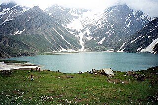
Sonamarg or Sonmarg, known as Sonamarag in Kashmiri, is a hill station located in the Ganderbal District of Jammu and Kashmir, India. It is located about 62 kilometers from Ganderbal Town and 80 kilometres (50 mi) northeast of the capital city, Srinagar.

Jammu and Kashmir is home to several valleys such as the Kashmir Valley, Chenab Valley, Sindh Valley and Lidder Valley. Some major tourist attractions in Jammu and Kashmir are Srinagar, with its renowned Dal Lake and Mughal Gardens, Gulmarg, Pahalgam, Bhaderwah, Patnitop and Jammu. Every year, thousands of Hindu pilgrims visit holy shrines of Vaishno Devi and Amarnath which has had a significant impact on the state's economy.
Mt Harmukh is a mountain with a peak elevation of 5,142 metres (16,870 ft), in Ganderbal district of Jammu and Kashmir in India. Harmukh is part of the Himalayas Range and is located between Sind River in the south and Kishanganga River in the north, rising above Gangabal Lake in the vicinity of Kashmir valley. It is mostly climbed from the northwestern side of Arin, via Kudara, Bandipore. Harmukh is considered sacred in Hinduism.

The Ganderbal district, is an Indian-administered district in Jammu and Kashmir in the disputed Kashmir region. It was formed in 2007 and has 6 subdistricts (tehsils): Kangan, Ganderbal, Tullamulla, Wakura, Lar, and Gund.
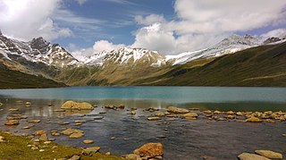
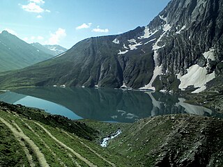
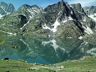
The Gangabal Lake, also called Haramukh Ganga, is an alpine high-altitude oligotrophic lake situated at the foot of Mount Haramukh in the Ganderbal district of Jammu and Kashmir, India. The lake has a maximum length of 2.5 kilometres (1.6 mi) and maximum width of 1 kilometre (0.62 mi). It is fed by precipitation, glaciers and springs and is home to many species of fish, including the brown trout. Water from the lake outflows into the nearby Nundkol Lake and then into the Sind River via Wangath Nallah. This lake is considered sacred in Hinduism as one of the abodes of Shiva, and Kashmiri Hindus perform an annual pilgrimage to the lake called Harmukh-Gangabal Yatra.

The Sind River or the Sindh River is a river in the Ganderbal district of the union territory of Jammu and Kashmir, India. It is a major tributary of the Jhelum River and is 108 km long.

The Gadsar Lake or Gad Sar(lit. 'lake of fishes'), also called Yem Sar, is an alpine high altitude oligotrophic lake in the Ganderbal district of Kashmir Division in Jammu and Kashmir, India. It has an elevation of 3,600 metres (11,800 ft), a maximum length of 0.85 km and maximum width of 0.76 km.
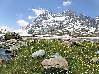
The Vishansar Lake or Vishan Sar is an alpine high-elevation oligotrophic lake, situated near Sonamarg in the Ganderbal district of Jammu and Kashmir, India, at an elevation of 3,710 metres (12,170 ft). It has a maximum length of 1 km, and maximum width of 0.6 km.
Aru known as Adav in Kashmiri, is a village, tourist spot in the Anantnag District of Jammu and Kashmir, India. It lies 53km from Anantnag city, the district headquarter. It is located around 12 km from Pahalgam, 11 km upstream from the Lidder River. Noted for its scenic meadows, lakes and mountains, it is a base camp for trekking to the Kolhoi Glacier, Tarsar Lake, Marsar and Herbaghwan Lake. The village lies on the left bank of the Aru river, which is a tributary of the Lidder river. Jammu & Kashmir’s biggest Fodder Seed Product Station is also located in the Aru village.
The Krishansar Lake or Krishan Sar is an alpine high elevation oligotrophic lake situated near Sonamarg, in the Ganderbal district of Jammu and Kashmir in India at an elevation of 3,710 metres (12,170 ft). It is located less than one kilometer northwest of Vishansar Lake, and has a maximum length of 0.95 km and maximum width of 0.6 km.
Sheshnag Lake is an alpine high elevation oligotrophic lake located in Anantnag district of Kashmir Valley in Jammu and Kashmir, India at an elevation of 3590 meters. It is situated on the track leading to the Amarnath cave, about 23 km from Pahalgam. It has a maximum length of 1.1 km and maximum width of 0.7 km.
Sirbal Peak is a mountain with a peak elevation of 5,235 metres (17,175 ft), in the Ganderbal district of the Indian union territory of Jammu and Kashmir, in the vicinity of Sonamarg. Sirbal Peak is part of the Himalaya Range, and is located between Sonamarg and Baltal. It lies 102 km northeast from Srinagar, 5 km from Sonamarg in the east. Sirbal Peak lies 6 km west of Zojila. It rises from a glacier 5 km ahead from Sonamarg on left side of NH 1D. The melt waters from the glacier add to the flow of Nallah Sindh.

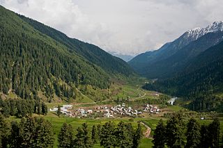
Naranag or (Nara Nag) is a tourist village and ancient Hindu pilgrimage site, near Ganderbal town in the Ganderbal district of the Kashmir Valley in Jammu and Kashmir. Well known for its ancient temple ruins complex, it is located around 16 km from Kangan, 10 km upstream from the Sind River. Noted for its scenic meadows, lakes and mountains, it is a base camp for trekking to the Mount Haramukh 16,870 ft and Gangabal Lake. The village lies at the left bank of the Wangath river, which is a tributary of the Sind River. Tourism hut at Naranag for any information and assistance tourism officials are available and hut is also provide for accommodation.
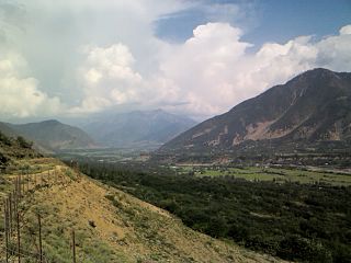
The Sind Valley is a Himalayan sub-valley of the Kashmir Valley in the Indian union territory of Jammu and Kashmir. The entrance of the Sind Valley lies 33 kilometres (21 mi) northeast of Srinagar the capital of Jammu and Kashmir. It is a 65 kilometres (40 mi) long gorge valley with an average width of 1 kilometre (0.62 mi).

The Tarsar Lake or Tar Sar is an almond-shaped, oligotrophic alpine lake situated in the Anantnag district of Jammu and Kashmir. On its west side lies Dachigam National Park, and on its south side lies Tral. The shortest route for reaching it, is from Surfraw Ganderbal, but it has a difficult terrain. Other trek routes to the lake are from Lidderwat and Nagaberan forest areas which fall in south Kashmir.

The Nundkol Lake or Nund Kol also known as Nandi Kund and Kalodaka Lake is an oligotrophic alpine lake situated in Ganderbal district of the Kashmir Valley in Jammu and Kashmir, India. This lake is considered sacred by Hindus.
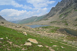
The Satsar Lake or Sat Sar consists of a group of seven small alpine lakes situated in Ganderbal district of the Kashmir Valley in Jammu and Kashmir, India.

The Tulail Valley (تلیل) is a Himalayan sub-valley of Gurez in the union territory of Jammu and Kashmir in India. The Valley lies 120 kilometres (75 mi) northeast of Bandipora and 200 kilometres (120 mi) from Srinagar the summer capital of Jammu and Kashmir. Tulail Valley lies immediate east of the Gurez Valley.The inhabitants of Tulail valley are known as "Dards"

Badamwari Athletes is an adventure sports group based in Kashmir, founded by Bilal Ahmad Beigh on 28 September 2023.The group focuses on promoting outdoor activities such as trekking, hiking, and physical fitness among the youth of the region. By leveraging Kashmir's stunning natural landscapes, Badamwari Athletes encourages a healthy, active lifestyle and promotes adventure tourism. Through its efforts, the group plays a significant role in inspiring local communities, particularly young people, to engage in outdoor sports, fostering physical well-being and contributing to the growth of tourism in the area.

