Jackson County is located in the western portion of the U.S. state of Missouri, on the border with Kansas. As of the 2020 census, the population was 717,204. making it the second-most populous county in the state. Although Independence retains its status as the original county seat, Kansas City, Missouri, serves as a second county seat and the center of county government. The county was organized December 15, 1826, and named for former Tennessee senator Andrew Jackson, who would become President of the United States three years later in 1829.
Independence is the county seat of Jackson County, Missouri, United States. It is a satellite city of Kansas City, Missouri, and is the largest suburb on the Missouri side of the Kansas City metropolitan area. In 2020, it had a total population of 123,011, making it the fifth-most populous city in Missouri.
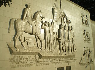
The Mormon Battalion was the only religious unit in United States military history in federal service, recruited solely from one religious body and having a religious title as the unit designation. The volunteers served from July 1846 to July 1847 during the Mexican–American War of 1846–1848. The battalion was a volunteer unit of between 534 and 559 Latter-day Saint men, led by Mormon company officers commanded by regular United States Army officers. During its service, the battalion made a grueling march of nearly 1,950 miles from Council Bluffs, Iowa, to San Diego, California.

The Mormon Trail is the 1,300-mile (2,100 km) long route from Illinois to Utah on which Mormon pioneers traveled from 1846–47. Today, the Mormon Trail is a part of the United States National Trails System, known as the Mormon Pioneer National Historic Trail.

Westport is a historic neighborhood and a main entertainment district in Kansas City, Missouri.

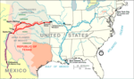
The Santa Fe Trail was a 19th-century route through central North America that connected Franklin, Missouri, with Santa Fe, New Mexico. Pioneered in 1821 by William Becknell, who departed from the Boonslick region along the Missouri River, the trail served as a vital commercial highway until 1880, when the railroad arrived in Santa Fe. Santa Fe was near the end of El Camino Real de Tierra Adentro which carried trade from Mexico City. The trail was later incorporated into parts of the National Old Trails Road and U.S. Route 66.

The Old Spanish Trail is a historical trade route that connected the northern New Mexico settlements of Santa Fe, New Mexico with those of Los Angeles, California and southern California. Approximately 700 mi (1,100 km) long, the trail ran through areas of high mountains, arid deserts, and deep canyons. It is considered one of the most arduous of all trade routes ever established in the United States. Explored, in part, by Spanish explorers as early as the late 16th century, the trail was extensively used by traders with pack trains from about 1830 until the mid-1850s. The area was part of Mexico from Mexican independence in 1821 to the Mexican Cession to the United States in 1848.
Josiah Gregg was an American merchant, explorer, naturalist, and author of Commerce of the Prairies, about the American Southwest and parts of northern Mexico. He collected many previously undescribed plants on his merchant trips and during the Mexican–American War, for which he has often been credited in botanical nomenclature. After the war he went to California, where he reportedly died of a fall from his mount due to starvation near Clear Lake on 25 February 1850, following a cross-country expedition which fixed the location of Humboldt Bay.
The Great Flood of 1844 is the biggest flood ever recorded on the Missouri River and Upper Mississippi River in North America in terms of discharge. The adjusted economic impact was not as great as subsequent floods because of the small population in the region at the time. The flood devastation was particularly widespread since the region had few levees at the time, so the waters were able to spread far from the normal banks. Among the hardest hit in terms of mortality were the Wyandot Indians, who lost 100 people in the diseases that occurred after the flood in the vicinity of today's Kansas City, Kansas.
The timeline of Kansas details past events that happened in what is present day Kansas. Located on the eastern edge of the Great Plains, the U.S. state of Kansas was the home of sedentary agrarian and hunter-gatherer Native American societies, many of whom hunted American bison. The region first appears in western history in the 16th century at the time of the Spanish conquest of the Aztec Empire, when Spanish conquistadors explored the unknown land now known as Kansas. It was later explored by French fur trappers who traded with the Native Americans. It became part of the United States in the Louisiana Purchase of 1803. In the 19th century, the first American explorers designated the area as the "Great American Desert."

The Temple Lot, located in Independence, Missouri, is the first site to be dedicated for the construction of a temple in the Latter Day Saint movement. The area was dedicated on August 3, 1831, by the movement's founder, Joseph Smith. It was purchased on December 19, 1831, by Edward Partridge to be the center of the New Jerusalem or "City of Zion" after Smith said he received a revelation stating that it would be the gathering spot of the Latter Day Saints during the last days.

The Santa Fe Trail Remains, also known as Santa Fe Trail Ruts, are a two-mile (3 km) section of the former 1,200-mile (1,900 km) long Santa Fe Trail, described as the "longest continuous stretch of clearly defined Santa Fe Trail rut remains in Kansas." Now owned by a preservation organization, the site is visible from a pull-off area on United States Route 50 near Dodge City, Kansas. The site was declared a National Historic Landmark in 1963.

Kaw Mission is a historic church mission in Council Grove, Kansas that was home, school and church to 30 Kaw boys from 1851 to 1854. It was listed on the National Register of Historic Places in 1971.
In the history of the American frontier, pioneers built overland trails throughout the 19th century, especially between 1840 and 1847 as an alternative to sea and railroad transport. These immigrants began to settle much of North America west of the Great Plains as part of the mass overland migrations of the mid-19th century. Settlers emigrating from the eastern United States did so with various motives, among them religious persecution and economic incentives, to move from their homes to destinations further west via routes such as the Oregon, California, and Mormon Trails. After the end of the Mexican–American War in 1849, vast new American conquests again encouraged mass immigration. Legislation like the Donation Land Claim Act and significant events like the California Gold Rush further encouraged settlers to travel overland to the west.

White Plume, also known as Nom-pa-wa-rah, Manshenscaw, and Monchousia, was a chief of the Kaw Indigenous American tribe. He signed a treaty in 1825 ceding millions of acres of Kaw land to the United States. Most present-day members of the Kaw Nation of Oklahoma trace their lineage back to him. He was the great-great-grandfather of Charles Curtis, 31st Vice President of the United States.

The historic 2,170-mile (3,490 km) Oregon Trail connected various towns along the Missouri River to Oregon's Willamette Valley. It was used during the 19th century by Great Plains pioneers who were seeking fertile land in the West and North.
Pedro Vial, or Pierre Vial, was a French explorer and frontiersman who lived among the Comanche and Wichita Indians for many years. He later worked for the Spanish government as a peacemaker, guide, and interpreter. He blazed trails across the Great Plains to connect the Spanish and French settlements in Texas, New Mexico, Missouri, and Louisiana. He led three Spanish expeditions that attempted unsuccessfully to intercept and halt the Lewis and Clark Expedition.
The Boonslick, or Boone's Lick Country, is a cultural region of Missouri along the Missouri River that played an important role in the westward expansion of the United States and the development of Missouri's statehood in the early 19th century. The Boone's Lick Road, a route paralleling the north bank of the river between St. Charles and Franklin, Missouri, was the primary thoroughfare for settlers moving westward from St. Louis in the early 19th century. Its terminus in Franklin marked the beginning of the Santa Fe Trail, which eventually became a major conduit for Spanish trade in the Southwestern United States. Later it connected to the large emigrant trails, including the Oregon and California Trails, used by pioneers, gold-seekers and other early settlers of the West. The region takes its name from a salt spring or "lick" in western Howard County, used by Nathan and Daniel Morgan Boone, sons of famed frontiersman Daniel Boone.

The Boone's Lick Road or Boonslick Trail was an early 1800s transportation route from eastern to central Missouri in the United States. Running east–west on the north side and roughly parallel to the Missouri River the trail began in the river port of St. Charles. The trail played a major role in the westward expansion of the United States and the development of Missouri's statehood. The trail's eventual terminus at Franklin was the start of the better-known Santa Fe Trail. First traced by the sons of Daniel Boone, the path originally ended at a salt lick in Howard County used by the pair to manufacture salt. Today the lick is maintained as Boone's Lick State Historic Site.
Daniel Morgan Boone was the son of Daniel Boone and a significant American pioneer, explorer, and frontiersman in his own right. He was a particularly key player in the early American exploration and settlement of Missouri.