
Hudson Valley Regional Airport, formerly known as Dutchess County Airport, is a county-owned public-use airport located on State Route 376 in the Town of Wappinger, Dutchess County, New York, United States, 4 miles (6.4 km) south of the central business district of Poughkeepsie. It is sometimes called Poughkeepsie Airport, which gives it the code POU. The airport provides corporate and general aviation transportation services.

New York's Orange County Airport is an untowered airport located one nautical mile (2 km) southwest of the village of Montgomery, in the Town of Montgomery, United States, at the junction of state highways 211 and 416. It is owned and operated by Orange County. It is included in the National Plan of Integrated Airport Systems for 2011–2015, which categorized it as a general aviation facility.
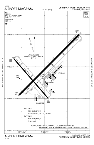
Chippewa Valley Regional Airport is a public use airport in Chippewa County, Wisconsin, United States. The airport is owned by Eau Claire county and is located 3 nautical miles north of the central business district of the city of Eau Claire, Wisconsin.

Aleknagik Airport, also known as Aleknagik (New) Airport, is a state-owned, public-use airport located one nautical mile (1.85 km) east of the central business district of Aleknagik, a city in the Dillingham Census Area of the U.S. state of Alaska.
Ogden–Hinckley Airport is a public airport four miles southwest of Ogden, in Weber County, Utah, United States. The National Plan of Integrated Airport Systems for 2019–2023 categorized it as a commercial service primary non-hub airport. Formerly Ogden Municipal Airport, it is billed as Utah's busiest municipal airport for private planes.
Buffalo-Lancaster Regional Airport is a privately owned, public use airport in Erie County, New York, United States. It is located three nautical miles (6 km) northeast of the central business district of Lancaster, a village in the Town of Lancaster, east of Buffalo.
Phoenix Deer Valley Airport is a public airport 24 miles north of central Phoenix, in Maricopa County, Arizona, United States, within the Phoenix city limits. It is owned by the City of Phoenix. The FAA's National Plan of Integrated Airport Systems for 2009–2013 categorized it as a reliever airport for Phoenix Sky Harbor International Airport.

Ambler Airport is a state-owned public-use airport located one nautical mile (1.85 km) north of the central business district of Ambler, a city in the Northwest Arctic Borough of the U.S. state of Alaska.
Springdale Municipal Airport is a public use airport in Washington County, Arkansas, United States. It is owned by the City of Springdale and located one nautical mile (2 km) southeast of its central business district. This airport is included in the National Plan of Integrated Airport Systems for 2011–2015, which categorized it as a general aviation facility.

San Gabriel Valley Airport — formerly El Monte Airport — is a public airport in El Monte, in Los Angeles County, California, United States. In November 2014, its name was changed from El Monte Airport to San Gabriel Valley Airport.
Machias Valley Airport is a town owned, public use airport located one nautical mile (2 km) southwest of the central business district of Machias, a town in Washington County, Maine, United States. It is included in the National Plan of Integrated Airport Systems for 2011–2015, which categorized it as a general aviation facility. The airport was once served by commercial airline service on Northeast Airlines.

McMinnville Municipal Airport is three miles southeast of McMinnville, in Yamhill County, Oregon. The FAA's National Plan of Integrated Airport Systems for 2009–2013 categorized it as a general aviation facility. It is across Oregon Route 18 from the Evergreen Aviation & Space Museum, home to the Hughes H-4 Hercules Spruce Goose flying boat.
Columbia County Airport is a county-owned public use airport in Columbia County, New York, United States. The airport is located four nautical miles (7 km) northeast of the central business district of Hudson, New York. It is a small un-towered general aviation airport in the Hudson Valley.
Scammon Bay Airport is a state-owned public-use airport located in Scammon Bay, a city in the Kusilvak Census Area of the U.S. state of Alaska.
Penn Yan Airport is a county-owned public-use airport located one nautical mile (1.8 km) south of the central business district of the Penn Yan, a village in Yates County, New York, United States. It is also known as Penn Yan - Yates County Airport.

New Castle Municipal Airport is a small municipal airport located in Union Township, Lawrence County, Pennsylvania serving Lawrence County, Pennsylvania, part of the Pittsburgh metropolitan area. Union Township is an outskirt of New Castle, Pennsylvania hence the name. The airport is located four nautical miles northwest of the central business district of New Castle. The airport is a public-owned airport and is controlled by the Lawrence County Airport Authority.
Randall Airport is a public use airport in Orange County, New York, United States. It is owned by Aerodrome Dev Corp and is located two nautical miles (3.74 km) southeast of the central business district of the City of Middletown. According to the FAA's National Plan of Integrated Airport Systems for 2007–2011, it is categorized as a reliever airport.
Williamson–Sodus Airport is a privately owned, public use airport in Wayne County, New York, United States. It is located three nautical miles (6 km) west of the central business district of Sodus, and east of Williamson. This airport is included in the National Plan of Integrated Airport Systems for 2011–2015, which categorized it as a reliever airport.
Tooele Valley Airport, also known as Bolinder Field, is a public use airport in Erda, Tooele County, Utah, United States. It is owned by the Salt Lake City Department of Airports and is located five nautical miles (9.26 km) northwest of the central business district of the City of Tooele. According to the FAA's National Plan of Integrated Airport Systems for 2009–2013, it is categorized as a general aviation airport.
Pauls Valley Municipal Airport is a city-owned, public-use airport located two nautical miles (4 km) south of the central business district of Pauls Valley, a city in Garvin County, Oklahoma, United States. It is included in the National Plan of Integrated Airport Systems for 2011–2015, which categorized it as a general aviation facility.
