Greater Pibor Administrative Area

Last updated
Greater Pibor Administrative Area
Boma
Flag of Greater Pibor Administrative Area.png
Greater Pibor Administrative Area Emblem.png
Greater Pibor Administrative Area.svg
Greater Pibor in South Sudan
CountryFlag of South Sudan.svg  South Sudan
Region Greater Upper Nile
Capital Pibor
Area
  Total41,962 km2 (16,202 sq mi)
Population
  Total214,676
Time zone UTC+2 (CAT)

The Greater Pibor Administrative Area is an administrative area in South Sudan. [1] [2]

Contents

History

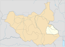
From the beginning of South Sudanese independence, the Anyuak, Jie, Kachepo, and Murle people in Jonglei sought greater autonomy from the Jonglei State government dominated by Nuer and Dinka. The resulting armed insurrections against the Government of South Sudan, initially dispersed, coalesced into the South Sudan Democratic Movement/Army (SSDM/A), which in turn was ultimately dominated by David Yau Yau and his Cobra Faction. Peace negotiations in the spring of 2014 led to a compromise that carved out two counties of Pibor and Pochalla within Jonglei state to create the new semi-autonomous Greater Pibor Administrative Area (GPAA). [3]

The special administrative area was dissolved after the creation of Boma State in 2015. [4] [5] [6]

As a result of a peace agreement signed in February 2020, Boma State was dissolved and Pibor was reconstituted as a special administrative area. [7]

Towns and cities

The capital of the state is Pibor.[ citation needed ] The population of Pibor was estimated at less than 1,000 people in 2005.[ citation needed ]. The town of Pochalla in Pochalla County lies directly on the border with Ethiopia.[ citation needed ] The town is about 470 kilometers (290 miles) from Juba via road.[ citation needed ]

Chief Administrators

TenureIncumbentParty
31 August 2005 – 30 December 2005 Akot Madhi SPLM
30 December 2005 – 21 May 2011 Akot Madhi SPLM
May 2011 – March 2013Kuol Monyluak Dak SPLM
February 2013 – June 2020 David Yau Yau SPLM
June 2020 – July 2021 Joshua Konyi
July 2021 – present Lokali Ame Bullen [8]

Related Research Articles

<span class="mw-page-title-main">Jonglei State</span> State of South Sudan

Jonglei State is a state of South Sudan with Bor as its centre of government and the biggest city. Jonglei state comprises nine counties: Bor, Akobo, Ayod, Uror, Duk, Nyirol, Pigi, Twic East, and Fangak. Jonglei State is the largest state by area before reorganisation, with an area of approximately 122,581 km2, as well as the most populous according to the 2008 census conducted in present-day South Sudan's second period of autonomy. The boundaries of the state were again changed as a result of a peace agreement signed on 22 February 2020.

<span class="mw-page-title-main">Flag of South Sudan</span> National flag

The flag of South Sudan was adopted following the signing of the Comprehensive Peace Agreement that ended the Second Sudanese Civil War. A similar version of the flag was previously used as the flag of the Sudan People's Liberation Movement. The flag of South Sudan predates the country, as the flag was adopted in 2005, while the country became independent in 2011.

Pochalla Airport is an airport serving Pochalla in South Sudan.

Pibor Airport is an airport serving the town of Pibor, in South Sudan.

Pochalla is a town in South Sudan.

<span class="mw-page-title-main">Pibor</span> Town in Pibor Administrative Area, South Sudan

Pibor, also called Pibor Post, is a town in South Sudan.

<span class="mw-page-title-main">Sudanese nomadic conflicts</span> Non-state conflicts between rival nomadic tribes

Sudanese nomadic conflicts are non-state conflicts between rival nomadic tribes taking place in the territory of Sudan and, since 2011, South Sudan. Conflict between nomadic tribes in Sudan is common, with fights breaking out over scarce resources, including grazing land, cattle and drinking water. Some of the tribes involved in these clashes have been the Messiria, Maalia, Rizeigat and Bani Hussein Arabic tribes inhabiting Darfur and West Kordofan, and the Dinka, Nuer and Murle African ethnic groups inhabiting South Sudan. Conflicts have been fueled by other major wars taking place in the same regions, in particular the Second Sudanese Civil War, the War in Darfur and the Sudanese conflict in South Kordofan and Blue Nile.

<span class="mw-page-title-main">States of South Sudan</span> First-level administrative division of South Sudan

The States of South Sudan were created out of the three historic former provinces of Bahr el Ghazal (northwest), Equatoria (southern), and Greater Upper Nile (northeast). The states are further divided into 79 counties.

<span class="mw-page-title-main">Greater Upper Nile</span> Region in South Sudan

The Greater Upper Nile is a region of northeastern South Sudan. It is named for the White Nile, a tributary of the Nile River in North and East Africa.

Ethnic violence in South Sudan has a long history among South Sudan's varied ethnic groups. South Sudan has 64 tribes with the largest being the Dinka, who constitute about 35% of the population and predominate in government. The second largest are the Nuers. Conflict is often aggravated among nomadic groups over the issue of cattle and grazing land and is part of the wider Sudanese nomadic conflicts.

The South Sudan Democratic Movement (SSDM), sometimes called the South Sudan Democratic Movement/Army (SSDM/A), was a South Sudanese militant group. Along with its armed wing, the South Sudan Defence Army (SSDA), rebelled against the government of South Sudan led by President Salva Kiir Mayardit and the Sudan People's Liberation Movement.

<span class="mw-page-title-main">Pibor County</span> County in Pibor Administrative Area, South Sudan

Pibor is a county in the Pibor Administrative Area, South Sudan. The county was part of the erstwhile Jonglei state.

<span class="mw-page-title-main">David Yau Yau</span>

David Yau Yau was a Governor of Boma State and the Chief Administrator of the Greater Pibor Administrative Area of South Sudan. He was previously the leader of a Murle insurrection against the South Sudanese government.

Kolnyang is a Payam in Bor County, in Jonglei State, South Sudan. It is situated on the east side of the Bahr al Jabal River, to the south of Bor, South Sudan. Kolnyang’s Malual-Chaat was where the liberation revolution that led to South Sudan independence started. Both 105 Battalion commander Alier NhialMangardit and the first fallen hero of revolt Maker Jool were from Kolnyang. Kolnyang Payam is Bor county’s southernmost payam, bordering Central Equatoria State to southwest, Pibor Administrative Area to the east, Lake State to the west and Eastern Equatoria State to the southeast.

<span class="mw-page-title-main">South Sudanese Civil War</span> 2013–2020 civil war in South Sudan

The South Sudanese Civil War was a multi-sided civil war in South Sudan between forces of the government and opposition forces. In December 2013, President Salva Kiir accused his former deputy Riek Machar and 10 others of attempting a coup d'état. Machar denied trying to start a coup and fled to lead the SPLM – in opposition (SPLM-IO). Fighting broke out between the Sudan People's Liberation Movement (SPLM) and SPLM-IO, igniting the civil war. Ugandan troops were deployed to fight alongside the South Sudanese government. The United Nations has peacekeepers in the country as part of the United Nations Mission in South Sudan (UNMISS).

Boma, is a town in South Sudan.

<span class="mw-page-title-main">Yei River State</span> State of South Sudan from 2015 to 2020

Yei River State was a state in South Sudan that existed from 2 October 2015 to 22 February 2020.

<span class="mw-page-title-main">Boma State</span> State of South Sudan from 2015 to 2020

Boma State was a state in South Sudan that existed between 2 October 2015 and 22 February 2020. It was located in the Greater Upper Nile region and was formerly part of the state of Jonglei. The state bordered Akobo State, Imatong State, Jonglei State, Kapoeta State, Bieh State, Terekeka State and the country of Ethiopia to the east.

Baidit is a Payam in Bor West County, in Jonglei State, South Sudan. It is situated on the east side of the Bahr al Jabal River a short distance north of Bor, South Sudan. Baidit is the county headquarters for Bor West County.

Anyidi is a Payam in Bor East County, in Jonglei State, South Sudan. It is situated to the east of Bor, the capital of Jonglei State, on the road connecting Bor and Pibor, in Boma State.

References

  1. "South Sudan's GPAA official refutes contest for governorship seat". Archived from the original on 2016-08-12. Retrieved 2016-08-11.
  2. @dekuekd (February 15, 2020). "So it has been decided that #SouthSudan shall revert to 10 states plus Abyei, Pibor and Ruweng Administrative Areas" (Tweet) via Twitter.
  3. Todisco, Claudio (March 2015). LeBrun, Emile (ed.). "Real but Fragile: The Greater Pibor Administrative Area" (PDF). Small Arms Survey. Graduate Institute of International and Development Studies (35). Retrieved 16 September 2015.
  4. "Yau Yau Dissolves Part and Officially Joins SPLM". Gurtong. 12 January 2016. Archived from the original on 5 April 2017. Retrieved 14 August 2016.
  5. "Calm in Pibor after tension over 'disarmament' and governor". Eye Radio. 2 February 2016. Retrieved 14 August 2016.
  6. "South Sudan's President appoints 28 Governors, defies peace agreement". South Sudan News Agency. 24 December 2015.
  7. "After 6 years of war, will peace finally come to South Sudan?".
  8. "Pibor welcomes new administrator".